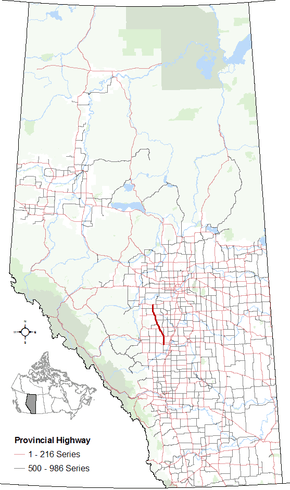
Alberta Highway 20
| ||||
|---|---|---|---|---|
 | ||||
| Route information | ||||
| Length: | 110 km (70 mi) | |||
| Major junctions | ||||
| South end: |
| |||
|
| ||||
| North end: |
| |||
| Location | ||||
| Specialized and rural municipalities: | Red Deer County, Lacombe County, Ponoka County, Wetaskiwin No. 10 County, Brazeau County | |||
| Towns: | Sylvan Lake, Bentley, Rimbey | |||
| Villages: | Breton | |||
| Highway system | ||||
|
Provincial highways in Alberta
| ||||

Alberta Provincial Highway No. 20 is a highway located in central Alberta, Canada, west of Highway 2.[1]
Highway 20 begins at Alsike along Highway 39 and proceeds 10 km south to Breton where it crosses Highway 616.[2] It continues south another 17 km to Winfield where it crosses Highway 13. From Winfield the highway continues south for another 15 km to Hoadley where Highway 611 branches off to the east. 12 km further south it goes through Bluffton where Highway 607 branches off to the west.[2]
Highway 53 branches off Highway 20 to the east towards Ponoka about 10 km south of Bluffton. The highway then travels 2 km before meeting Highway 20A, which proceeds into Rimbey. Highway 20 turns left and proceeds another 3 km before Highway 53 branches off to the west through Rimbey to Highway 22. The highway proceeds southeast for 22 km where Highway 771 branches off to the north. The highway meets Highway 12 just east of Bentley 2 km later.[2]
From Highway 12, it goes directly south for 16 km where it meets Highway 11A at a four way stop at the east end of Sylvan Lake. From Highway 11A it travels another 4 km to its end at Highway 11.[3]
Major intersections
From south to north:[4]
| Rural/specialized municipality | Location | km[5] | mi | Destinations | Notes |
|---|---|---|---|---|---|
| Red Deer County | Sylvan Lake | 0 | 0.0 | Future | Traffic signals Proposed interchange Proposed Hwy 781 realignment[6] |
| 4 | 2.5 | Roundabout | |||
| Lacombe County | | 11 | 6.8 | Aspelund Road – Blackfalds | |
| Bentley | 20 | 12 | |||
| | 22 | 14 | |||
| Ponoka County | Rimbey | 43 | 27 | Hwy 20 turns west | |
| 45 | 28 | Hwy 20 branches north Hwy 53 concurrency begins | |||
| | 47 | 29 | Hwy 53 concurrency ends | ||
| Bluffton | 54 | 34 | |||
| Hoadley | 69 | 43 | |||
| County of Wetaskiwin No. 10 | Winfield | 84 | 52 | ||
| Brazeau County | Breton | 101 | 63 | ||
| Alsike | 110 | 68 | |||
1.000 mi = 1.609 km; 1.000 km = 0.621 mi
| |||||
Highway 20A

Alberta Provincial Highway No. 20A is the designation of a 3.2 km (2.0 mi) alternate route off Highway 20 serving the Town of Rimbey. It starts within Rimbey at Highway 53 and ends 1.6 km (1.0 mi) to the north at Highway 20.[1][2]
Major intersections
The entire route is in Ponoka County.
| Location | km[5] | mi | Destinations | Notes | |||
|---|---|---|---|---|---|---|---|
| Rimbey | 0 | 0.0 | Township Road 424 | East entrance into Rimbey along 50 Avenue | |||
| 1.6 | 0.99 | 51 Street | Four way stop, Hwy 20A branches north Hwy 53 concurrency begins | ||||
| 3.2 | 2.0 | North entrance into Rimbey; Hwy 20A ends. | |||||
| Continues as | |||||||
1.000 mi = 1.609 km; 1.000 km = 0.621 mi
| |||||||
References
- 1 2 "Provincial Highway 1-216 Progress Chart" (PDF). Alberta Transportation. March 2015. Archived (PDF) from the original on April 10, 2016. Retrieved October 12, 2016.
- 1 2 3 4 Google (October 31, 2016). "Highways 20 in Alberta" (Map). Google Maps. Google. Retrieved October 31, 2016.
- ↑ Alberta Official Road Map (Map) (2015 ed.). Alberta Tourism, Parks and Recreation. § J–5 and K–5.
- ↑ Alberta Road Atlas (2005 ed.). Oshawa, ON: MapArt Publishing Corp. p. 64.
- 1 2 "Google Maps". Google Maps. Retrieved May 26, 2016.
- ↑ "Highway 11 Functional Planning Study - Executive Summary" (PDF). Government of Alberta. McElhanny Consulting Services Ltd. December 2013. Retrieved April 26, 2016.