Albussac
| Albussac | ||
|---|---|---|
|
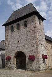
The church in Albussac | ||
| ||
 Albussac | ||
|
Location within Nouvelle-Aquitaine region  Albussac | ||
| Coordinates: 45°08′20″N 1°50′11″E / 45.1389°N 1.8364°ECoordinates: 45°08′20″N 1°50′11″E / 45.1389°N 1.8364°E | ||
| Country | France | |
| Region | Nouvelle-Aquitaine | |
| Department | Corrèze | |
| Arrondissement | Tulle | |
| Canton | Argentat | |
| Intercommunality | Pays d'Argentat | |
| Government | ||
| • Mayor (2008–2020) | Raymond Raoul | |
| Area1 | 36.26 km2 (14.00 sq mi) | |
| Population (2009)2 | 688 | |
| • Density | 19/km2 (49/sq mi) | |
| Time zone | CET (UTC+1) | |
| • Summer (DST) | CEST (UTC+2) | |
| INSEE/Postal code | 19004 / 19380 | |
| Elevation |
240–637 m (787–2,090 ft) (avg. 350 m or 1,150 ft) | |
|
1 French Land Register data, which excludes lakes, ponds, glaciers > 1 km² (0.386 sq mi or 247 acres) and river estuaries. 2 Population without double counting: residents of multiple communes (e.g., students and military personnel) only counted once. | ||
Albussac is a French commune in the Corrèze department in the Nouvelle-Aquitaine region of central France.
The inhabitants of the commune are known as Albussacois or Albussacoises[1]
The commune has been awarded one flower by the National Council of Towns and Villages in Bloom in the Competition of cities and villages in Bloom.[2]
Geography
Albussac is located south-west of the Massif Central about 500m above sea level. It has an oceanic climate with temperatures ranging from 25 °C to 30 °C in summer and 9 °C in winter with periods of frequent cold waves in January and February (often -10 to -12 °C at sunrise and no more than 3 °C to 0 °C at 3pm). Albussac has regular snowfalls in winter with 20 cm of snow common.
The Roanne has its source in the commune.
Albussac is located some 100 km south-east of Limoges and 20 km east of Brive-la-Gaillarde. It can be accessed by the D921 road which comes from Beynat in the west and continues east through the commune and the village and continues to Saint-Chamant. There is also the D87 road branching off the D940 just south of Sainte-Fortunade and coming through the northern border of the commune and south-east to the village. There is a network of country roads in the commune and numerous hamlets and villages. These are:
- Aubiat
- Bedaine
- Chanterel
- Chastrusse
- Jassat
- La Commanderie
- La Salesse
- Lachaud
- Lafage
- Laumond
- Laverne
- Le Bros-Bas
- Le Bros-Haut
- Le Mas
- Les Quatre-Routes
- Madelbos
- Malmaury
- Prezat
- Roche-de-Vic
- Roussanne
- Teillol
The Ruisseau de la Font Blanc rises in the south of the commune which flows north gathering several tributaries and joining the Ruisseau de Rochette flowing from the west continuing north-east to join the Valeine at the edge of the commune. The Valeine also flows from the west north of the village gathering numerous tributaries in the commune and continuing to the east. There is also the Ruisseau de Mejeu forming part of the northern border flowing east to join the Souvigne. In the west an unnamed stream flows north-west forming the western border of the commune and joins the Ruisseau de la Grande.
Neighbouring communes and villages
 |
Le Chastang | Lagarde-Enval | Saint-Sylvain | |
| Beynat | |
Saint-Chamant | ||
| ||||
| | ||||
| Serilhac | Neuville | Argentat |
Heraldry
.svg.png) |
Blazon: Gules, a chevron of Or over a crescent Argent, in chief azure with three mullets of six points in Or. |
Administration
List of Successive Mayors of Albussac[3]
| From | To | Name | Party | Position |
|---|---|---|---|---|
| 1803 | 1806 | Jean Chastrusse | ||
| Aymard Dancie | ||||
| Gabriel-Noël Bourdet | ||||
| Jean-Baptiste Bourdet | ||||
| 1844 | 1862 | Jean-Baptiste Chastrusse | ||
| 1873 | 1879 | Jean-Baptiste Désiré Naudoux | ||
| 1879 | 1890 | François Nugon | ||
| 1911 | Jules Nugon | |||
| 2001 | 2020 | Raymond Raoul |
(Not all data is known)
Demography
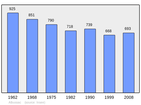
In 2009, the commune had 688 inhabitants. The evolution of the number of inhabitants is known through the population censuses conducted in the town since 1793. From the 21st century, a census of municipalities with fewer than 10,000 inhabitants is held every five years, unlike larger towns that have a sample survey every year.[Note 1]
| 1793 | 1800 | 1806 | 1821 | 1831 | 1836 | 1841 | 1846 | 1851 |
|---|---|---|---|---|---|---|---|---|
| 1,068 | 1,116 | 1,068 | 1,270 | 1,294 | 1,355 | 1,336 | 1,389 | 1,359 |
| 1856 | 1861 | 1866 | 1872 | 1876 | 1881 | 1886 | 1891 | 1896 |
|---|---|---|---|---|---|---|---|---|
| 1,403 | 1,444 | 1,335 | 1,414 | 1,400 | 1,332 | 1,466 | 1,391 | 1,537 |
| 1901 | 1906 | 1911 | 1921 | 1926 | 1931 | 1936 | 1946 | 1954 |
|---|---|---|---|---|---|---|---|---|
| 1,401 | 1,497 | 1,460 | 1,191 | 1,227 | 1,183 | 1,149 | 1,038 | 1,007 |
| 1962 | 1968 | 1975 | 1982 | 1990 | 1999 | 2006 | 2009 | - |
|---|---|---|---|---|---|---|---|---|
| 925 | 851 | 790 | 718 | 739 | 668 | - | 688 | - |
Sources : Ldh/EHESS/Cassini until 1962, INSEE database from 1968 (population without double counting and municipal population from 2006)
Sites and Monuments
- The Church of Saint Martin (12th century)
 is registered as an historical monument.[4] The Church contains two items which are registered as historical objects:
- The Murel Waterfall
- A Lime tree called "Sully" is more than 400 years old and one of the last in the Limousin region.
- Roche de Vic is a former Gallic oppidum that dominated the region.
Notable People linked to the commune
- Yvon Bourdet, writer. He evoked Albussac in his book: In Praise of Patois or the Itinerary of an Occitan
- Emmanuel Berl, journalist and essayist, lived in the town during the Second World War at a place called La Malmaurie with his wife, the singer Mireille
See also
- Communes of the Corrèze department
- Cantons of the Corrèze department
- Arrondissements of the Corrèze department
Bibliography
- Doctor Albert Massonie: Old Times in Albussac, Tulle, 1990 (French)
Notes
- ↑ At the beginning of the 21st century, the methods of identification have been modified by law No. 2002-276 of 27 February 2002 , the so-called "law of local democracy" and in particular Title V "census operations" which allow, after a transitional period running from 2004 to 2008, the annual publication of the legal population of the different French administrative districts. For municipalities with a population greater than 10,000 inhabitants, a sample survey is conducted annually, the entire territory of these municipalities is taken into account at the end of the period of five years. The first "legal population" after 1999 under this new law came into force on 1 January 2009 and was based on the census of 2006.
References
- ↑ Inhabitants of Corrèze (French)
- ↑ Albussac in the Competition for Towns and Villages in Bloom (French)
- ↑ List of Mayors of France (French)
- ↑ Ministry of Culture, Mérimée PA00099645 Church of Saint Martin (French)
- ↑ Ministry of Culture, Palissy PM19000789 Cross: Christ on the Cross
(French)

- ↑ Ministry of Culture, Palissy PM19000002 Bronze Bell (French)
External links
- Albussac on the old National Geographic Institute website (French)
- Albussac on Lion1906
- Albußac on the 1750 Cassini Map
- Albussac on the INSEE website (French)
- INSEE (French)
| Wikimedia Commons has media related to Albussac. |