Nespouls
| Nespouls | ||
|---|---|---|
|
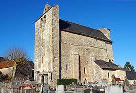
The fortified church of Saint-Julien, in Nespouls | ||
| ||
 Nespouls | ||
|
Location within Nouvelle-Aquitaine region  Nespouls | ||
| Coordinates: 45°03′02″N 1°30′12″E / 45.0506°N 1.5033°ECoordinates: 45°03′02″N 1°30′12″E / 45.0506°N 1.5033°E | ||
| Country | France | |
| Region | Nouvelle-Aquitaine | |
| Department | Corrèze | |
| Arrondissement | Brive-la-Gaillarde | |
| Canton | Brive-la-Gaillarde-Sud-Ouest | |
| Intercommunality | Portes du Causse | |
| Government | ||
| • Mayor (2008–2014) | François Patier | |
| Area1 | 20.14 km2 (7.78 sq mi) | |
| Population (2008)2 | 610 | |
| • Density | 30/km2 (78/sq mi) | |
| Time zone | CET (UTC+1) | |
| • Summer (DST) | CEST (UTC+2) | |
| INSEE/Postal code | 19147 / 19600 | |
| Elevation |
203–366 m (666–1,201 ft) (avg. 300 m or 980 ft) | |
|
1 French Land Register data, which excludes lakes, ponds, glaciers > 1 km² (0.386 sq mi or 247 acres) and river estuaries. 2 Population without double counting: residents of multiple communes (e.g., students and military personnel) only counted once. | ||
.svg.png)
Nespouls is a commune in the Corrèze department in central France.
Population
| Historical population | ||
|---|---|---|
| Year | Pop. | ±% |
| 1962 | 321 | — |
| 1968 | 348 | +8.4% |
| 1975 | 340 | −2.3% |
| 1982 | 358 | +5.3% |
| 1990 | 413 | +15.4% |
| 1999 | 503 | +21.8% |
| 2008 | 610 | +21.3% |
See also
References
| Wikimedia Commons has media related to Nespouls. |
This article is issued from Wikipedia - version of the 2/25/2015. The text is available under the Creative Commons Attribution/Share Alike but additional terms may apply for the media files.