Saint-Cernin-de-Larche
| Saint-Cernin-de-Larche | ||
|---|---|---|
|
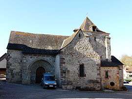
The church in Saint-Cernin-de-Larche | ||
| ||
 Saint-Cernin-de-Larche | ||
|
Location within Nouvelle-Aquitaine region  Saint-Cernin-de-Larche | ||
| Coordinates: 45°06′14″N 1°24′57″E / 45.1039°N 1.4158°ECoordinates: 45°06′14″N 1°24′57″E / 45.1039°N 1.4158°E | ||
| Country | France | |
| Region | Nouvelle-Aquitaine | |
| Department | Corrèze | |
| Arrondissement | Brive-la-Gaillarde | |
| Canton | Larche | |
| Intercommunality | Vézère-Causse | |
| Government | ||
| • Mayor (2008–2014) | Gérard Eymard | |
| Area1 | 9.15 km2 (3.53 sq mi) | |
| Population (2008)2 | 576 | |
| • Density | 63/km2 (160/sq mi) | |
| Time zone | CET (UTC+1) | |
| • Summer (DST) | CEST (UTC+2) | |
| INSEE/Postal code | 19191 / 19600 | |
| Elevation |
105–312 m (344–1,024 ft) (avg. 98 m or 322 ft) | |
|
1 French Land Register data, which excludes lakes, ponds, glaciers > 1 km² (0.386 sq mi or 247 acres) and river estuaries. 2 Population without double counting: residents of multiple communes (e.g., students and military personnel) only counted once. | ||
.svg.png)
Saint-Cernin-de-Larche is a commune in the Corrèze department in central France.
Population
| Historical population | ||
|---|---|---|
| Year | Pop. | ±% |
| 1962 | 309 | — |
| 1968 | 309 | +0.0% |
| 1975 | 297 | −3.9% |
| 1982 | 319 | +7.4% |
| 1990 | 425 | +33.2% |
| 1999 | 456 | +7.3% |
| 2008 | 576 | +26.3% |
See also
References
| Wikimedia Commons has media related to Saint-Cernin-de-Larche. |
This article is issued from Wikipedia - version of the 2/26/2015. The text is available under the Creative Commons Attribution/Share Alike but additional terms may apply for the media files.