Liginiac
| Liginiac | ||
|---|---|---|
|
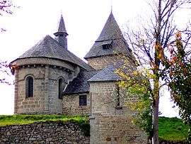
The church in Liginiac | ||
| ||
 Liginiac | ||
|
Location within Nouvelle-Aquitaine region  Liginiac | ||
| Coordinates: 45°24′59″N 2°20′03″E / 45.4164°N 2.3342°ECoordinates: 45°24′59″N 2°20′03″E / 45.4164°N 2.3342°E | ||
| Country | France | |
| Region | Nouvelle-Aquitaine | |
| Department | Corrèze | |
| Arrondissement | Ussel | |
| Canton | Neuvic | |
| Intercommunality | Gorges de la haute Dordogne | |
| Government | ||
| • Mayor (2008–2014) | Jean Valade | |
| Area1 | 28.53 km2 (11.02 sq mi) | |
| Population (2008)2 | 629 | |
| • Density | 22/km2 (57/sq mi) | |
| Time zone | CET (UTC+1) | |
| • Summer (DST) | CEST (UTC+2) | |
| INSEE/Postal code | 19113 / 19160 | |
| Elevation | 351–692 m (1,152–2,270 ft) | |
|
1 French Land Register data, which excludes lakes, ponds, glaciers > 1 km² (0.386 sq mi or 247 acres) and river estuaries. 2 Population without double counting: residents of multiple communes (e.g., students and military personnel) only counted once. | ||
.svg.png)
Liginiac is a commune in the Corrèze department in central France.
Geography
The Triouzoune forms most of the commune's western boundary.
Population
| Historical population | ||
|---|---|---|
| Year | Pop. | ±% |
| 1962 | 858 | — |
| 1968 | 725 | −15.5% |
| 1975 | 601 | −17.1% |
| 1982 | 618 | +2.8% |
| 1990 | 603 | −2.4% |
| 1999 | 629 | +4.3% |
| 2008 | 629 | +0.0% |
See also
References
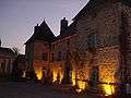 La Mairie
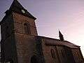 L'Église
| Wikimedia Commons has media related to Liginiac. |
This article is issued from Wikipedia - version of the 2/12/2016. The text is available under the Creative Commons Attribution/Share Alike but additional terms may apply for the media files.