Lafage-sur-Sombre
| Lafage-sur-Sombre | ||
|---|---|---|
|
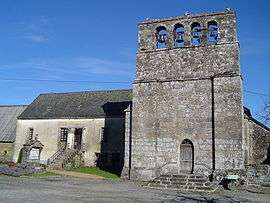
The church and presbytery in Lafage-sur-Sombre | ||
| ||
 Lafage-sur-Sombre | ||
|
Location within Nouvelle-Aquitaine region  Lafage-sur-Sombre | ||
| Coordinates: 45°17′47″N 2°04′19″E / 45.2964°N 2.0719°ECoordinates: 45°17′47″N 2°04′19″E / 45.2964°N 2.0719°E | ||
| Country | France | |
| Region | Nouvelle-Aquitaine | |
| Department | Corrèze | |
| Arrondissement | Tulle | |
| Canton | Lapleau | |
| Government | ||
| • Mayor (2008–2014) | Paule Busson | |
| Area1 | 18.94 km2 (7.31 sq mi) | |
| Population (2008)2 | 119 | |
| • Density | 6.3/km2 (16/sq mi) | |
| Time zone | CET (UTC+1) | |
| • Summer (DST) | CEST (UTC+2) | |
| INSEE/Postal code | 19097 / 19320 | |
| Elevation | 493–686 m (1,617–2,251 ft) | |
|
1 French Land Register data, which excludes lakes, ponds, glaciers > 1 km² (0.386 sq mi or 247 acres) and river estuaries. 2 Population without double counting: residents of multiple communes (e.g., students and military personnel) only counted once. | ||
.svg.png)
Lafage-sur-Sombre is a commune in the Corrèze department in central France.
Population
| Historical population | ||
|---|---|---|
| Year | Pop. | ±% |
| 1962 | 139 | — |
| 1968 | 207 | +48.9% |
| 1975 | 158 | −23.7% |
| 1982 | 162 | +2.5% |
| 1990 | 159 | −1.9% |
| 1999 | 116 | −27.0% |
| 2008 | 119 | +2.6% |
See also
References
| Wikimedia Commons has media related to Lafage-sur-Sombre. |
This article is issued from Wikipedia - version of the 2/25/2015. The text is available under the Creative Commons Attribution/Share Alike but additional terms may apply for the media files.