Saint-Ybard
| Saint-Ybard | ||
|---|---|---|
|
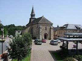
The church in Saint-Ybard | ||
| ||
 Saint-Ybard | ||
|
Location within Nouvelle-Aquitaine region  Saint-Ybard | ||
| Coordinates: 45°26′56″N 1°31′21″E / 45.4489°N 1.5225°ECoordinates: 45°26′56″N 1°31′21″E / 45.4489°N 1.5225°E | ||
| Country | France | |
| Region | Nouvelle-Aquitaine | |
| Department | Corrèze | |
| Arrondissement | Tulle | |
| Canton | Uzerche | |
| Intercommunality | Pays d'Uzerche | |
| Government | ||
| • Mayor (2008–2014) | Jean-Jacques Dumas | |
| Area1 | 30.05 km2 (11.60 sq mi) | |
| Population (2008)2 | 656 | |
| • Density | 22/km2 (57/sq mi) | |
| Time zone | CET (UTC+1) | |
| • Summer (DST) | CEST (UTC+2) | |
| INSEE/Postal code | 19248 / 19140 | |
| Elevation |
270–497 m (886–1,631 ft) (avg. 395 m or 1,296 ft) | |
|
1 French Land Register data, which excludes lakes, ponds, glaciers > 1 km² (0.386 sq mi or 247 acres) and river estuaries. 2 Population without double counting: residents of multiple communes (e.g., students and military personnel) only counted once. | ||
.svg.png)
Saint-Ybard is a commune in the Corrèze department in central France.
Population
| Historical population | ||
|---|---|---|
| Year | Pop. | ±% |
| 1962 | 700 | — |
| 1968 | 770 | +10.0% |
| 1975 | 703 | −8.7% |
| 1982 | 660 | −6.1% |
| 1990 | 591 | −10.5% |
| 1999 | 590 | −0.2% |
| 2008 | 656 | +11.2% |
See also
References
External links
| Wikimedia Commons has media related to Saint-Ybard. |
This article is issued from Wikipedia - version of the 2/26/2015. The text is available under the Creative Commons Attribution/Share Alike but additional terms may apply for the media files.