Lanteuil
| Lanteuil | ||
|---|---|---|
|
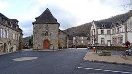
The church and school, in Lanteuil | ||
| ||
 Lanteuil | ||
|
Location within Nouvelle-Aquitaine region  Lanteuil | ||
| Coordinates: 45°07′43″N 1°39′39″E / 45.1286°N 1.6608°ECoordinates: 45°07′43″N 1°39′39″E / 45.1286°N 1.6608°E | ||
| Country | France | |
| Region | Nouvelle-Aquitaine | |
| Department | Corrèze | |
| Arrondissement | Brive-la-Gaillarde | |
| Canton | Beynat | |
| Intercommunality | Canton de Beynat | |
| Government | ||
| • Mayor (2008–2014) | Christian Derachinois | |
| Area1 | 22.68 km2 (8.76 sq mi) | |
| Population (2008)2 | 510 | |
| • Density | 22/km2 (58/sq mi) | |
| Time zone | CET (UTC+1) | |
| • Summer (DST) | CEST (UTC+2) | |
| INSEE/Postal code | 19105 / 19190 | |
|
1 French Land Register data, which excludes lakes, ponds, glaciers > 1 km² (0.386 sq mi or 247 acres) and river estuaries. 2 Population without double counting: residents of multiple communes (e.g., students and military personnel) only counted once. | ||
.svg.png)
Lanteuil is a commune in the Corrèze department in central France.
Population
| Historical population | ||
|---|---|---|
| Year | Pop. | ±% |
| 1962 | 523 | — |
| 1968 | 469 | −10.3% |
| 1975 | 427 | −9.0% |
| 1982 | 406 | −4.9% |
| 1990 | 431 | +6.2% |
| 1999 | 478 | +10.9% |
| 2008 | 510 | +6.7% |
See also
References
| Wikimedia Commons has media related to Lanteuil. |
This article is issued from Wikipedia - version of the 2/25/2015. The text is available under the Creative Commons Attribution/Share Alike but additional terms may apply for the media files.