Bassignac-le-Haut
| Bassignac-le-Haut | ||
|---|---|---|
|
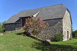
An old barn in Bassignac-le-Haut | ||
| ||
 Bassignac-le-Haut | ||
|
Location within Nouvelle-Aquitaine region  Bassignac-le-Haut | ||
| Coordinates: 45°12′44″N 2°04′21″E / 45.2122°N 2.0725°ECoordinates: 45°12′44″N 2°04′21″E / 45.2122°N 2.0725°E | ||
| Country | France | |
| Region | Nouvelle-Aquitaine | |
| Department | Corrèze | |
| Arrondissement | Tulle | |
| Canton | Saint-Privat | |
| Intercommunality | Community of communes of Canton de Saint-Privat | |
| Government | ||
| • Mayor (2012–2020) | Jean Claude Turquet | |
| Area1 | 18.37 km2 (7.09 sq mi) | |
| Population (2010)2 | 204 | |
| • Density | 11/km2 (29/sq mi) | |
| Time zone | CET (UTC+1) | |
| • Summer (DST) | CEST (UTC+2) | |
| INSEE/Postal code | 19018 / 19220 | |
| Elevation |
253–628 m (830–2,060 ft) (avg. 540 m or 1,770 ft) | |
|
1 French Land Register data, which excludes lakes, ponds, glaciers > 1 km² (0.386 sq mi or 247 acres) and river estuaries. 2 Population without double counting: residents of multiple communes (e.g., students and military personnel) only counted once. | ||
Bassignac-le-Haut is a French commune in the Corrèze department in the Nouvelle-Aquitaine region of central France.[1]
The inhabitants of the commune are known as Bassignacois or Bassignacoises .[2]
Geography
Bassignac-le-Haut is located in the Massif Central some 20 km north-east of Argentat and 20 km south-east of Tulle. Access to the commune is by the D13 road from Darazac in the south which passes through the commune and the village before continuing north-east along the banks of the river then across to Saint-Merd-de-Lapleau. Apart from the village there are the hamlets of Le Bousquet, Vaujour, Le Mas, Vernac, Maurel, and Ymons in the commune. The commune is mostly farmland but heavily forested along the river.[3][4]
A lake formed by the Barrage du Chastang dam on the Dordogne river forms all the western and northern border of the commune. The Ruisseau de vaujour rises in the north-west of the commune and flows the short distance north-west to the Dordogne. Similarly the Ruisseau du Roc Chabrier rises in the north and flows north into the Dordogne. The Ruisseau de la Cascade flows north through the eastern part of the commune to join the Dordogne east of the commune. The Ruisseau de Vieilzot rises just south of the commune and forms much of the southern border as it floes west to join the Dordogne in the south-western tip of the commune.[3][4]
Mapping
A list of online mapping systems can be displayed by clicking on the coordinates (latitude and longitude) in the top right hand corner of this article.
Neighbouring communes and villages
 |
Gros-Chastang | Saint-Merd-de-Lapleau | | |
| La Roche-Canillac | |
Auriac | ||
| ||||
| | ||||
| Saint-Martin-la-Méanne | Darazac |
History
Bassignac-le-Haut appears as Baßignac le Haut on the 1750 Cassini Map[5] and as Bassignac le Haut on the 1790 version.[6]
Heraldry
.svg.png) |
The official status of the blazon remains to be determined.
Blazon: |
Administration
| From | To | Name | Party | Position |
|---|---|---|---|---|
| 2001 | 2007 | Raymond Delmas | ||
| 2007 | 2008 | Hubert Lavesque | ||
| 2008 | 2011 | Josette Puyraymond | ||
| 2012 | 2020 | Jean Claude Turquet[8] |
(Not all data is known)
Demography
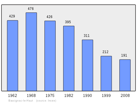
In 2010 the commune had 204 inhabitants. The evolution of the number of inhabitants is known from the population censuses conducted in the commune since 1793. From the 21st century, a census of communes with fewer than 10,000 inhabitants is held every five years, unlike larger communes that have a sample survey every year.[Note 1]
| 1793 | 1800 | 1806 | 1821 | 1831 | 1836 | 1841 | 1846 | 1851 |
|---|---|---|---|---|---|---|---|---|
| 761 | 668 | 770 | 795 | 801 | 790 | 760 | 822 | 868 |
| 1856 | 1861 | 1866 | 1872 | 1876 | 1881 | 1886 | 1891 | 1896 |
|---|---|---|---|---|---|---|---|---|
| 833 | 828 | 813 | 802 | 813 | 837 | 774 | 728 | 704 |
| 1901 | 1906 | 1911 | 1921 | 1926 | 1931 | 1936 | 1946 | 1954 |
|---|---|---|---|---|---|---|---|---|
| 667 | 653 | 611 | 511 | 548 | 486 | 507 | 518 | 468 |
| 1962 | 1968 | 1975 | 1982 | 1990 | 1999 | 2006 | 2010 | - |
|---|---|---|---|---|---|---|---|---|
| 429 | 476 | 426 | 395 | 311 | 212 | 184 | 204 | - |
Sources : Ldh/EHESS/Cassini until 1962, INSEE database from 1968 (population without double counting and municipal population from 2006)
Culture and heritage

Religious heritage
The commune has several religious buildings and sites that are registered as historical monuments:
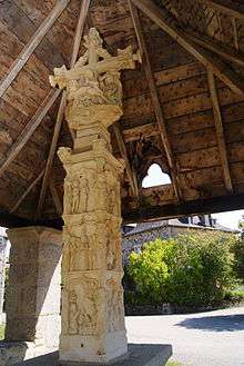
- The Ouradour Cemetery Cross (Middle Ages)
 [9]
[9] - The Ciriex Cemetery Cross (12th century)[10]
- A Covered Cross in the old cemetery (15th century)[11]
- The Church of Saint-Pierre-ès-Liens (16th century)[12] The Church contains several items that are registered as historical objects:
Notable people linked to the commune
- Stephen of Obazine (1085-1154), priest and hermit famed for his pious nature, born in the commune.
See also
Notes and references
Notes
- ↑ At the beginning of the 21st century, the methods of identification have been modified by Law No. 2002-276 of 27 February 2002, the so-called "law of local democracy" and in particular Title V "census operations" allows, after a transitional period running from 2004 to 2008, the annual publication of the legal population of the different French administrative districts. For communes with a population greater than 10,000 inhabitants, a sample survey is conducted annually and the entire territory of these communes is taken into account at the end of the period of five years. The first "legal population" after 1999 under this new law came into force on 1 January 2009 and was based on the census of 2006.
References
- ↑ Bassignac-le-Haut on Lion1906
- ↑ Inhabitants of Corrèze (French)
- 1 2 3 Bassignac-le-Haut on Google Maps
- 1 2 Bassignac-le-Haut on the Géoportail from National Geographic Institute (IGN) website (French)
- ↑ Baßignac le Haut on the 1750 Cassini Map
- ↑ Bassignac le Haut on the 1790 Cassini Map
- ↑ List of Mayors of France (French)
- ↑ General Council website - Bassignac-le-Haut (French)
- ↑ Ministry of Culture, Mérimée PA00099663 Ouradour Cemetery Cross (French)
- ↑ Ministry of Culture, Mérimée PA00099665 Ciriex Cemetery Cross (French)
- ↑ Ministry of Culture, Mérimée PA00099664 Covered Cross (French)
- ↑ Ministry of Culture, Mérimée PA00099666 Church of Saint-Pierre-ès-Liens (French)
- ↑ Ministry of Culture, Palissy PM19000851 Painting with frame: Saint Roch
 (French)
 - ↑ Ministry of Culture, Palissy PM19000850 Painting with frame: John the Baptist
(French)
- ↑ Ministry of Culture, Palissy PM19000849 Altar Painting with frame: Christ on the Cross
(French)
- ↑ Ministry of Culture, Palissy PM19000848 Painting with frame: Presentation of the Rosary to Saints Dominic and Catherine
(French)
External links
- Bassignac-le-Haut Official website (French)
| Wikimedia Commons has media related to Bassignac-le-Haut. |