Lestards
| Lestards | ||
|---|---|---|
|
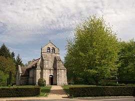
The church of Saint-Martial, in Lestards | ||
| ||
 Lestards | ||
|
Location within Nouvelle-Aquitaine region  Lestards | ||
| Coordinates: 45°30′59″N 1°52′29″E / 45.5164°N 1.8747°ECoordinates: 45°30′59″N 1°52′29″E / 45.5164°N 1.8747°E | ||
| Country | France | |
| Region | Nouvelle-Aquitaine | |
| Department | Corrèze | |
| Arrondissement | Ussel | |
| Canton | Bugeat | |
| Intercommunality | Bugeat - Sornac - Millevaches au Cœur | |
| Government | ||
| • Mayor (2008–2014) | Christophe Petit | |
| Area1 | 18.52 km2 (7.15 sq mi) | |
| Population (2008)2 | 110 | |
| • Density | 5.9/km2 (15/sq mi) | |
| Time zone | CET (UTC+1) | |
| • Summer (DST) | CEST (UTC+2) | |
| INSEE/Postal code | 19112 / 19170 | |
| Elevation | 518–894 m (1,699–2,933 ft) | |
|
1 French Land Register data, which excludes lakes, ponds, glaciers > 1 km² (0.386 sq mi or 247 acres) and river estuaries. 2 Population without double counting: residents of multiple communes (e.g., students and military personnel) only counted once. | ||
.svg.png)
Lestards is a commune in the Corrèze department in central France.
Population
| Historical population | ||
|---|---|---|
| Year | Pop. | ±% |
| 1962 | 123 | — |
| 1968 | 139 | +13.0% |
| 1975 | 116 | −16.5% |
| 1982 | 92 | −20.7% |
| 1990 | 106 | +15.2% |
| 1999 | 101 | −4.7% |
| 2008 | 110 | +8.9% |
See also
References
| Wikimedia Commons has media related to Lestards. |
This article is issued from Wikipedia - version of the 7/20/2016. The text is available under the Creative Commons Attribution/Share Alike but additional terms may apply for the media files.