Bandar Abbas
| Bandar Abbas بندر عباس گامبرون | ||
|---|---|---|
| City | ||
|
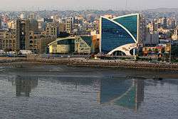
A view of the Taleghani Boulevard area | ||
| ||
| Nickname(s): The Crab Port | ||
 Bandar Abbas | ||
| Coordinates: IR 27°11′N 56°16′E / 27.183°N 56.267°ECoordinates: IR 27°11′N 56°16′E / 27.183°N 56.267°E | ||
| Country |
| |
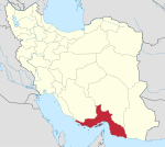
| Province | Hormozgan | |
| County | Bandar Abbas | |
| District | Central | |
| Settled | prior to 600 BCE | |
| Government | ||
| • Type | Municipality | |
| • Mayor | Abbas Aminizadeh | |
| Elevation | 9 m (30 ft) | |
| Population (2011) | ||
| • Total | 435,751[1] | |
| Time zone | IRST (UTC+3:30) | |
| • Summer (DST) | IRDT (UTC+4:30) | |
| Postal code | 79177 | |
| Area code(s) | (+98) 076 | |
| Website |
bandarabbas | |
Bandar Abbas (Persian: بندرعباس) ![]() pronunciation or Bandar-e ‘Abbās (Persian: بندر عباس), also romanized as Bandar ‘Abbās and Bandar ‘Abbāsī; formerly known as Cambarão and Porto Comorão to Portuguese traders, as Gombroon to English traders and as Gamrun or Gumrun to Dutch merchants,[2] also Jaroon (to the Arabs) and Cameron (to the English), is a port city and capital of Hormozgān Province on the southern coast of Iran, on the Persian Gulf. The city occupies a strategic position on the narrow Strait of Hormuz, and it is the location of the main base of the Iranian Navy. Bandar Abbas is also the capital and largest city of Bandar Abbas County. At the 2006 census, its population was 367,508, with 89,404 families.[3]
pronunciation or Bandar-e ‘Abbās (Persian: بندر عباس), also romanized as Bandar ‘Abbās and Bandar ‘Abbāsī; formerly known as Cambarão and Porto Comorão to Portuguese traders, as Gombroon to English traders and as Gamrun or Gumrun to Dutch merchants,[2] also Jaroon (to the Arabs) and Cameron (to the English), is a port city and capital of Hormozgān Province on the southern coast of Iran, on the Persian Gulf. The city occupies a strategic position on the narrow Strait of Hormuz, and it is the location of the main base of the Iranian Navy. Bandar Abbas is also the capital and largest city of Bandar Abbas County. At the 2006 census, its population was 367,508, with 89,404 families.[3]
Etymology
Bandar Abbas has always been a port, and as such its various names have all addressed this function. The most common name over time (Gameroon) has traditionally been said to derive from Persian gümrük, customhouse (from Late Greek kommerkion, from Latin commercium, "commerce"), but is now speculated to be from Persian kamrūn, shrimp (which in Portuguese is camarão, similar to the former Portuguese name).[4] It's current name is derived from that of Shah Abbas I [5] paired with 'port.'
History
Pre-Islamic history
The earliest record of Bandar Abbas is during the reign of Darius the Great (between 522 and 486 BCE). Darius's commander, Silacus, embarked from Bandar Abbas to India and the Red Sea. During Alexander's conquest of the Persian Empire, Bandar Abbas was known under the name of Hormirzad.
In the year 630 CE, Maharaja Derbar Raja of Gemeron was defeated in battle and escaped to Ceylon, and he was later blown off course by a storm to the remote shores of Kuala Sungai Qilah, Kedah (now Malaysia). The inhabitants of Kedah found him to be a valiant and intelligent person, and they made him the king of Kedah. In the year 634 CE, a new kingdom was formed in Kedah consisting of Persian royalty and native Malay of Hindu faith, the capital was Langkasuka (see Kedah Sultanate and Early history of Kedah).
.jpg)
Portuguese period
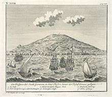
By the 16th century, Bandar Abbas was known as Gamrūn to the Persians. In 1565, a European navigator called it Bamdel Gombruc (that is, Bandar Gümrük, or "Customhouse Port"), citing this as the Persian and Turkish name. Bandar Abbas was conquered by the Portuguese in 1514, and was an important location to protect their commerce in the Persian Gulf and India.[6][7] They named the city Comorão, due to the presence of lobsters and crabs on its shores.
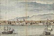
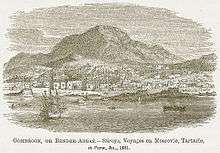
In 1614, Comorão was taken by ‘Abbās the Great from the Portuguese and renamed Bandar-e ‘Abbās ("Port of ‘Abbās"). Backed by the English navy, ‘Abbās developed the city (known to the English-speaking world as Gombraun) into a major port. By 1622, the Portuguese and English names had been officially combined to form Combrù or Combu, although the inhabitants still called it Bandar-e ‘Abbās. Sir Thomas Herbert said the official English name was Gumbrown, but pronounced [gŏmrōōn]. He wrote in 1630 that "some (but I commend them not) write it Gamrou, others Gomrow, and othersome Cummeroon." By the 1670s, the city was known as Gameroon.
In 1622 CE Shah Abbas defeated Portuguese troops with the help of British troops and Iranian commander Imam Quli Khan. In honor of this victory Gumbroon was renamed Bandar Abbas Port. In the current division of Bandar Abbas in Hormozgan province and one of the most important strategic and commercial center is in the vicinity of the Persian Gulf and Oman Sea.
Omani period
Between 1794 and 1868, Bandar Abbas was under the control of the Sultanate of Oman and Zanzibar through a lease agreement with Persia. The details of the original lease apparently differed between the Arabic and Persian versions. The Omanis controlled the coastal stretch of some 100 miles from Sadij to Khamir, and inland about 30 miles, as far as Shamil. They also controlled the islands of Hormuz and Qeshm. In 1823, the Persians attempted to oust the Omanis, but the sultan managed to keep his hold on Bandar through bribery and tribute of the governor of Shiraz. In 1845–46, an army under the governor general of Fars menaced Bandar to extort tribute, while another army under the governor of Kerman besieged Minab. The Omanis threatened to blockade Persia, but the British resident at Bushir convinced them to back down.[8]
The Persians recovered the city in 1854, while the sultan was in Zanzibar. Under British pressure following the Anglo-Persian War in 1856, Persia renewed Oman's lease on favourable terms. It was clarified that the leased territory belonged to the province of Fars and that the Persian flag would fly over Bandar Abbas. The rental rate was also increased. Under British pressure the agreement was renewed in 1868, but at a higher rate of rent and for a shorter duration. Two months after its renewal, the lease was cancelled by the Persian government, citing a clause which permitted its termination if the sultan of Oman were overthrown.[8]
Contemporary history
An earthquake in July 1902 damaged parts of the city, including the governor´s house and the customs office, and nearby Kishm island.[9]
Mohammad Reza Shah Pahlavi paid particular attention to Bandar Abbas as a strategic port and during his time the government invested huge amounts of capital in the infrastructure.
Bandar Abbas serves as a major shipping point, mostly for imports, and has a long history of trade with India, particularly the port of Surat. Thousands of tourists visit the city and nearby islands including Qeshm and Hormuz every year.
Bandar Abbas was a small fishing port of about 17,000 people in 1955, prior to initial plans to develop it as a major harbor. By 2001, it had grown into a major city. It has a population of 450,000 (2011 estimate).
Geography
Bandar Abbas is situated on flat ground with an average altitude of 9 metres (30 ft) above sea level. The nearest elevated areas are Mt. Geno, 17 kilometres (11 mi) to the north, and Mt. Pooladi, 16 kilometres (9.9 mi) to the northwest of the city. The closest river to Bandar Abbas is the River Shoor, which rises on Mt. Geno and flows into the Persian Gulf, 10 kilometres (6.2 mi) east of the city. South of the city is the island of Qeshm.
Climate
Bandar Abbas has a hot desert climate (Köppen climate classification BWh). Maximum temperature in summers can reach 49 °C (120 °F) while in winters the minimum temperature may drop to 5 °C (41 °F). The annual rainfall is around 170 millimetres (6.7 in) and the average relative humidity is 65%.
In the summer, Bandar Abbas sees some of the highest average dew points of any city in the world, averaging 27 °C (81 °F) and frequently exceeding 30 °C (86 °F). As a result, heat indices generally top 50 °C (122 °F) for most days during the summer.[10][11] This immense humidity causes summer diurnal ranges to be lower than in most desert climates, and is a result of air flow from the warm waters of the Persian Gulf.
| Climate data for Bandar Abbas | |||||||||||||
|---|---|---|---|---|---|---|---|---|---|---|---|---|---|
| Month | Jan | Feb | Mar | Apr | May | Jun | Jul | Aug | Sep | Oct | Nov | Dec | Year |
| Record high °C (°F) | 32.0 (89.6) |
33.0 (91.4) |
39.0 (102.2) |
42.0 (107.6) |
47.0 (116.6) |
51.0 (123.8) |
48.0 (118.4) |
46.0 (114.8) |
45.0 (113) |
42.0 (107.6) |
38.0 (100.4) |
32.0 (89.6) |
51 (123.8) |
| Average high °C (°F) | 23.5 (74.3) |
24.4 (75.9) |
27.7 (81.9) |
31.6 (88.9) |
36.3 (97.3) |
38.4 (101.1) |
38.2 (100.8) |
37.7 (99.9) |
36.8 (98.2) |
35 (95) |
30.4 (86.7) |
25.5 (77.9) |
32.13 (89.83) |
| Daily mean °C (°F) | 18.1 (64.6) |
19.4 (66.9) |
23.1 (73.6) |
26.8 (80.2) |
31.2 (88.2) |
33.7 (92.7) |
34.4 (93.9) |
34.0 (93.2) |
32.5 (90.5) |
29.6 (85.3) |
24.3 (75.7) |
19.7 (67.5) |
27.23 (81.03) |
| Average low °C (°F) | 12.1 (53.8) |
14 (57) |
17.5 (63.5) |
20.9 (69.6) |
24.7 (76.5) |
28 (82) |
30.3 (86.5) |
30.1 (86.2) |
27.7 (81.9) |
23.5 (74.3) |
18 (64) |
13.5 (56.3) |
21.69 (71.04) |
| Record low °C (°F) | 3.0 (37.4) |
5.4 (41.7) |
7.6 (45.7) |
11.5 (52.7) |
17.0 (62.6) |
20.0 (68) |
25.2 (77.4) |
25.0 (77) |
21.0 (69.8) |
12.0 (53.6) |
6.0 (42.8) |
2.0 (35.6) |
2 (35.6) |
| Average precipitation mm (inches) | 39.7 (1.563) |
47.5 (1.87) |
34.8 (1.37) |
10.7 (0.421) |
4.8 (0.189) |
0.0 (0) |
0.6 (0.024) |
2.2 (0.087) |
0.8 (0.031) |
1.3 (0.051) |
5.0 (0.197) |
24.0 (0.945) |
171.4 (6.748) |
| Average precipitation days (≥ 1.0 mm) | 3.3 | 3.1 | 2.6 | 1.3 | 0.2 | 0 | 0.1 | 0.2 | 0.1 | 0.1 | 0.4 | 2.3 | 13.7 |
| Average relative humidity (%) | 64 | 68 | 67 | 64 | 61 | 64 | 68 | 69 | 67 | 64 | 61 | 63 | 65 |
| Mean monthly sunshine hours | 220.1 | 211.9 | 232.5 | 242.4 | 312.7 | 302.2 | 264.6 | 270.1 | 270.1 | 283.4 | 251.2 | 228.8 | 3,090 |
| Source: NOAA (1961-1990)[12] | |||||||||||||
Transportation
Air
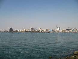
Bandar Abbas International Airport has capacity and facilities for landing large transport airplanes.
Roads
Bandar Abbas is accessible via the following highways:
 Bandar Abbas-Sirjan, 300 kilometres (190 mi) to the northeast.
- Bandar Abbas-Kerman, 484 kilometres (301 mi) to the northeast.
- Bandar Abbas-Shiraz, 650 kilometres (400 mi) to the north.
- Bandar Abbas-Zahedan, 722 kilometres (449 mi) to the east.
Rail
Since 1993, Bandar Abbas has been the southern terminus of Islamic Republic of Iran Railways' main North–South corridor that links it to Yazd, Qom, Tehran and Qazvin to the north.
Language
Original Bandaris (residents of Bandar Abbas) speak Bandari (بندری), a dialect of Persian. Bandari has loanwords from various European languages (e.g. tawāl, "towel") and some from Arabic (e.g. atā [اتى], "to come"), Persian and Balochi.
Products
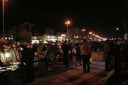
- Date, citrus, tobacco and factory goods (e.g. canned tuna fish).
- Bandar Abbas is the site of a Chinese-built cruise missile production facility for the manufacture and upgrade of Silkworm (CSS-N-2) cruise missiles.[13]
Exports
- Transit goods, dates, citrus, tobacco, fishery; Bandar Abbas was formerly famous for its export of Iranian pottery, and was known in the west as "goombroon". "Goombroon ware" was the original porcelain imported to England from Goombroon in the early 20th century. It was later replaced by china ware imported from China. Kaolin was the mineral from which the porcelain was made.[14]
Sports
Aluminium Hormozgan is Bander Abbas's main football (soccer) team. The team was founded in 2006. In 2012 they were promoted to the Iran Pro League but after their first season there they were relegated back to the Azadegan League where they currently play.
Bander Abbas also has a second less supported team, Shahrdari Bandar Abbas, which was founded in 2005 and is the municipality's team. They currently also compete in the Azadegan League.
Education
University
- Bandar Abbas University of Medical Sciences
- University of Hormozgan
- Islamic Azad University of Bandar Abbas
See also
Notes
- ↑ http://www.citypopulation.de/Iran-MajorCities.html
- ↑ Bandar Abbas can be found at GEOnet Names Server, at this link, by opening the Advanced Search box, entering "-3055107" in the "Unique Feature Id" form, and clicking on "Search Database".
- ↑ "Census of the Islamic Republic of Iran, 1385 (2006)". Islamic Republic of Iran. Archived from the original (Excel) on 2011-11-11.
- ↑ Hobson Jobson Dictionary
- ↑ http://www.iranicaonline.org/articles/bandar-e-abbasi
- ↑ Iran tourism and touring official website,Bandar Abbas
- ↑ SalamIranProvince of Bandar Abbas
- 1 2 Lawrence G. Potter, "The Consolidation of Iran's Frontier on the Persian Gulf in the Nineteenth Century", in Roxane Farmanfarmaian (ed.), War and Peace in Qajar Persia: Implications Past and Present (Routledge: 2008), pp. 125–48.
- ↑ "Latest intelligence - Earthquake shocks on the Persian Gulf". The Times (36824). London. 19 July 1902. p. 7.
- ↑
- ↑
- ↑ "Bandar Abbas 1961-1990". National Oceanic and Atmospheric Administration. Retrieved December 29, 2012.
- ↑ "Bandar Abbas N27°11' E56°16'". Federation of American Scientists. Retrieved 5 October 2014.
- ↑ Mrs G MacKenzie (21 February 1947). "Pottery Production Can Be Mastered with Simple Tools". Halfmoon Bay, British Columbia: The Coast News. Retrieved 5 October 2014.
References
- . الكوخردى ، محمد ، بن يوسف، (كُوخِرد حَاضِرَة اِسلامِيةَ عَلي ضِفافِ نَهر مِهران) الطبعة الثالثة ،دبى: سنة 199۷ للميلاد Mohammed Kookherdi (1997) Kookherd, an Islamic civil at Mehran river, third edition: Dubai
- . کامله،القاسمی، بنت شیخ عبدالله، (تاریخ لنجة) مکتبة دبي للتوزیع، الامارات: الطبعة الثانية عام ۱۹۹۳ للمیلاد
- . الوحیدی الخنجی، حسین بن علی بن احمد، «تاریخ لنجه» ، الطبعة الثانية دبی: دار الأمة للنشر والتوزیع، ۱۹۸۸ للمیلاد
- . اطلس گیتاشناسی استانهای ایران [Atlas Gitashenasi Ostanhai Iran] (Gitashenasi Province Atlas of Iran)
External links
| Wikimedia Commons has media related to Bandar Abbas. |
| Wikisource has the text of the 1911 Encyclopædia Britannica article Bander Abbāsi. |
- Bandar Abbas on Iran Chamber Society (www.iranchamber.com)
- Bandar Abbas Port
- www.hums.ac.ir/english/province/hormozgan english/bandar_abbas.htm
