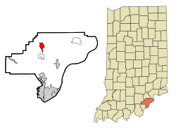
Henryville, Indiana
| Henryville, Indiana | |
|---|---|
| Census-designated place | |
 Location in the state of Indiana | |
| Coordinates: 38°32′28″N 85°46′0″W / 38.54111°N 85.76667°WCoordinates: 38°32′28″N 85°46′0″W / 38.54111°N 85.76667°W | |
| Country | United States |
| State | Indiana |
| County | Clark |
| Township | Monroe |
| Area | |
| • Total | 2.9 sq mi (7.5 km2) |
| • Land | 2.9 sq mi (7.5 km2) |
| • Water | 0.0 sq mi (0.0 km2) |
| Elevation[1] | 518 ft (158 m) |
| Population (2010) | |
| • Total | 1,905 |
| • Density | 536/sq mi (207.1/km2) |
| Time zone | EST (UTC-5) |
| • Summer (DST) | EDT (UTC-4) |
| ZIP code | 47126 |
| Area code(s) | 812 |
| FIPS code | 18-33142[2] |
| GNIS feature ID | 436039 |
Henryville is a census-designated place (CDP) in Monroe Township, Clark County, in the U.S. state of Indiana.[3] The population was 1,905 at the 2010 census.
Henryville is home to Indiana's oldest state forest, Clark State Forest, and birthplace of entrepreneur Colonel Harland Sanders, whose iconic image appears in the Kentucky Fried Chicken logo.[4]
History
In 1850, the village of Morristown was established. It was renamed Henryville in 1853 to honor Colonel Henry Ferguson, who was once a colonel in the Pennsylvania militia. He purchased the land on which Henryville was established, and helped persuade Pennsylvania Railroad officials to run the line through Clark County.[5] The Henryville post office was established in 1865.[6]
Henryville is the birthplace of "Colonel" Harland Sanders, founder of Kentucky Fried Chicken.[7]
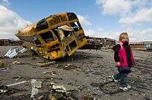
2012 Tornado
At approximately 3:15 p.m. (EST) on March 2, 2012, an EF-4 tornado caused extensive damage to Henryville, killing at least three people.[4] It was on the ground for more than 50 miles.[8] The storm destroyed Henryville Elementary School and Henryville Jr/Sr High School.[9][10][11]
Geography
Henryville is located at 38°32′28″N 85°46′0″W / 38.54111°N 85.76667°W (38.541088, -85.766677).[12] According to the United States Census Bureau, the CDP has a total area of 2.9 square miles (7.5 km2), all land.
Climate
The climate in this area is characterized by hot, humid summers and generally mild to cool winters. According to the Köppen Climate Classification system, Henryville has a humid subtropical climate, abbreviated "Cfa" on climate maps.[13]
Demographics
| Historical population | |||
|---|---|---|---|
| Census | Pop. | %± | |
| 2000 | 1,545 | — | |
| 2010 | 1,905 | 23.3% | |
| U.S. Decennial Census | |||
As of the census[2] of 2000, there were 1,545 people, 583 households, and 434 families residing in the CDP. The population density was 535.6 people per square mile (207.1/km²). There were 609 housing units at an average density of 211.1/sq mi (81.6/km²). The racial makeup of the CDP was 99.16% White, 0.06% African American, 0.13% Native American, 0.26% Asian, and 0.39% from two or more races. Hispanic or Latino of any race were 0.26% of the population.
There were 583 households out of which 38.1% had children under the age of 18 living with them, 58.8% were married couples living together, 11.0% had a female householder with no husband present, and 25.4% were non-families. 21.6% of all households were made up of individuals and 7.9% had someone living alone who was 65 years of age or older. The average household size was 2.65 and the average family size was 3.07.
In the CDP the population was spread out with 26.1% under the age of 18, 10.4% from 18 to 24, 32.6% from 25 to 44, 22.1% from 45 to 64, and 8.7% who were 65 years of age or older. The median age was 34 years. For every 100 females there were 97.1 males. For every 100 females age 18 and over, there were 96.4 males.
The median income for a household in the CDP was $49,405, and the median income for a family was $55,000. Males had a median income of $38,938 versus $22,043 for females. The per capita income for the CDP was $17,745. About 6.2% of families and 4.9% of the population were below the poverty line, including none of those under age 18 and 27.0% of those age 65 or over.
Education
Henryville has an elementary,[14] and junior/senior high school.[15]
Infrastructure
Highway
Interstate 65 passes north-south through the west side of Henryville and roughly parallels the older U.S. Route 31. Indiana State Road 160 intersects the previous two roads in Henryville.
Rail
The Louisville & Indiana Railroad runs north-south through Henryville and roughly parallels U.S. Route 31.[16]
References
- ↑ "US Board on Geographic Names". United States Geological Survey. 2007-10-25. Retrieved 2008-01-31.
- 1 2 "American FactFinder". United States Census Bureau. Retrieved 2008-01-31.
- ↑ "Henryville, Indiana". Geographic Names Information System. United States Geological Survey. Retrieved 2016-10-23.
- 1 2 Indiana town completely gone after tornado kills at least 3; Sun Times; March 2, 2012.
- ↑ Yael Kasander (March 12, 2007). "Henry Ferguson". Indiana Public Media. Retrieved March 8, 2012.
- ↑ "Clark County". Jim Forte Postal History. Retrieved 30 August 2014.
- ↑ Witzel, Morgen (15 May 2005). Encyclopedia of History of American Management. A&C Black. p. 447. ISBN 978-1-84371-131-5.
- ↑ Alford, Roger; Jim Suhr (2012-03-04). "Storms demolish small towns in Ind., Ky.; 38 dead". The Philadelphia Inquirer. Associated Press. Retrieved 2012-03-04.
- ↑ Susan Candiotti and Moni Basu (2012-03-03). "March tornadoes: One day there was a town; the next day it was gone". CNN. Retrieved 2012-05-22.
- ↑ "U.S. News - 'Crash, bang, break' as students, staff survive twister hitting school". Usnews.msnbc.msn.com. Retrieved 2012-05-22.
- ↑ "Storms demolish small towns in Ind., Ky.; 38 dead". CBS News. Retrieved 2012-05-22.
- ↑ "US Gazetteer files: 2010, 2000, and 1990". United States Census Bureau. 2011-02-12. Retrieved 2011-04-23.
- ↑ Climate Summary for Henryville, Indiana
- ↑ ":: West Clark Community Schools ::". Wclark.k12.in.us. 2012-03-02. Retrieved 2012-05-22.
- ↑ ":: West Clark Community Schools ::". Wclark.k12.in.us. 2012-05-14. Retrieved 2012-05-22.
- ↑ State of Indiana 2012 Rail System Map
External links
Municipalities and communities of Clark County, Indiana, United States | ||
|---|---|---|
| Cities | ||
| Towns | ||
| Townships | ||
| CDPs | ||
| Unincorporated communities |
| |
| Footnotes | ‡This populated place also has portions in an adjacent county or counties | |
