Carmel, Indiana
| Carmel, Indiana | |
|---|---|
| City | |
| City of Carmel | |
|
City Hall during CarmelFest | |
| Motto: "A Partnership For the Tomorrow" | |
 Location in the state of Indiana | |
| Coordinates: 39°58′N 86°6′W / 39.967°N 86.100°WCoordinates: 39°58′N 86°6′W / 39.967°N 86.100°W | |
| Country | United States |
| State | Indiana |
| County | Hamilton |
| Township | Clay |
| Government | |
| • Mayor | James Brainard (R) (1996-present) |
| Area[1] | |
| • City | 48.55 sq mi (125.74 km2) |
| • Land | 47.46 sq mi (122.92 km2) |
| • Water | 1.09 sq mi (2.82 km2) |
| Elevation | 853 ft (260 m) |
| Population (2010)[2] | |
| • City | 79,191 |
| • Estimate (2014[3]) | 85,927 |
| • Density | 1,769.9/sq mi (644.39/km2) |
| • Metro | 2,414,639 (23rd) |
| Time zone | EST (UTC-5) |
| • Summer (DST) | EDT (UTC-4) |
| ZIP codes | 46032, 46033, 46082, 46280 |
| Area code(s) | 317 |
| FIPS code | 18-10342 |
| GNIS feature ID | 0432143[4] |
| Interstate Highways |
|
| U.S. Highways | |
| Website |
www |
.jpg)
Carmel /ˈkɑːrməl/ is a suburban city in Hamilton County, Indiana, United States located immediately north of Indianapolis. It has been one of the fastest-growing communities in the country. In 2012, Carmel was selected the Best Place to Live in United States by CNN Money magazine.[5] The population was estimated 85,927 in 2014 by the US Census Bureau,[6] making it the fifth-largest city in Indiana.
History
Carmel was originally called Bethlehem and, under the latter name, was laid out and platted in 1837.[7] The original settlers were predominantly Quakers.[8] Today, the plot first established in Bethlehem, located at the intersection of Rangeline Road and Main Street, is marked by a clock tower, donated by the local Rotary Club in 2002. A post office was established as Carmel in 1846.[9] The town of Bethlehem was renamed Carmel in 1874, at which time it was incorporated.[10]
In 1924, one of the first automatic traffic signals in the U.S. was installed at the intersection of Main Street and Rangeline Road. The signal was the invention of Leslie Haines and is currently in the old train station on the Monon Trail.[11]
The Carmel Monon Depot, John Kinzer House, and Thornhurst Addition are listed on the National Register of Historic Places.[12][13]
Geography
According to the 2010 census, Carmel has a total area of 48.545 square miles (125.73 km2), of which 47.46 square miles (122.92 km2) (or 97.76%) is land and 1.085 square miles (2.81 km2) (or 2.24%) is water.[1]
Major east-west streets in Carmel generally end in a 6, and include 96th Street (the Southern border), 106th, 116th, 126th, 131st, 136th and 146th (the Northern Border). The numbering system is aligned to that of Marion and Hamilton counties. Main Street (131st) runs East-West through Carmel's Art & Design District; Carmel Drive runs East-West through a main shopping area; and City Center Drive runs East-West near Carmel's new City Center project.
North-south streets are not numbered, and include (west to east) Michigan, Shelborne, Towne, Ditch, Spring Mill, Meridian, Guilford, Rangeline, Keystone, Carey, Gray, Hazel Dell and River. Some of these roads are continuations of corresponding streets within Indianapolis. Towne Road replaces the name Township Line Road at 96th Street, while Westfield Boulevard becomes Rangeline north of 116th Street. Meridian Street (US 31) and Keystone Parkway (formerly SR 431) are the major thoroughfares, extending from (within Carmel) I–465 in the south and merging just south of 146th Street.
-
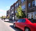
This photo displays the city's burgeoning Arts & Design District.
-
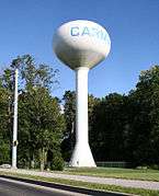
One of Carmel's water towers, located near the Westfield border on 146th street
Demographics
| Historical population | |||
|---|---|---|---|
| Census | Pop. | %± | |
| 1880 | 92 | — | |
| 1890 | 471 | 412.0% | |
| 1900 | 498 | 5.7% | |
| 1910 | 626 | 25.7% | |
| 1920 | 598 | −4.5% | |
| 1930 | 682 | 14.0% | |
| 1940 | 771 | 13.0% | |
| 1950 | 1,009 | 30.9% | |
| 1960 | 1,442 | 42.9% | |
| 1970 | 6,691 | 364.0% | |
| 1980 | 18,272 | 173.1% | |
| 1990 | 25,380 | 38.9% | |
| 2000 | 37,733 | 48.7% | |
| 2010 | 79,191 | 109.9% | |
| Est. 2015 | 88,713 | [14] | 12.0% |
| U.S. Decennial Census[15] 2012 Estimate[16] | |||
According to a 2010 estimate, the median household income in the city was $101,494.[17] Males had a median income of $93,340 versus $62,943 for females. The per capita income for the city was $85,320. About 1.6% of families and 2.5% of the population were below the poverty line, including 2.5% of those under age 18 and 2.2% of those age 65 or over.
The median home price in 2014 was $294,000.[18]
2010 census
As of the census[2] of 2010, there were 79,191 people, 28,997 households, and 21,855 families residing in the city. The population density was 1,668.6 inhabitants per square mile (644.3/km2). There were 30,738 housing units at an average density of 647.7 per square mile (250.1/km2). The racial makeup of the city was 85.4% White, 3.0% African American, 0.2% Native American, 8.9% Asian, 0.7% from other races, and 1.8% from two or more races. Hispanic or Latino of any race were 2.5% of the population.
There were 28,997 households of which 41.7% had children under the age of 18 living with them, 66.6% were married couples living together, 6.3% had a female householder with no husband present, 2.4% had a male householder with no wife present, and 24.6% were non-families. 20.8% of all households were made up of individuals and 6.7% had someone living alone who was 65 years of age or older. The average household size was 2.71 and the average family size was 3.18.
The median age in the city was 39.2 years. 29.4% of residents were under the age of 18; 5.3% were between the ages of 18 and 24; 25.2% were from 25 to 44; 29.7% were from 45 to 64; and 10.4% were 65 years of age or older. The gender makeup of the city was 48.7% male and 51.3% female.
Government
The government consists of a mayor and a city council. The current mayor is James Brainard[19] The city council consists of seven members. Five are elected from individual districts. Two are elected at-large.
Roundabouts
Carmel has become the unofficial roundabout capital of the United States, due to the installation of over 94 roundabouts[20] and demolishing 78 sets of traffic signals. Mayor James Brainard has said, "We have more than any other city in the US. It's a trend now in the United States. There are more and more roundabouts being built every day because of the expense saved and more importantly the safety." Many of the roundabouts are also well landscaped, thus improving the image of the highway network. More importantly, however, the decor and landscaping within the roundabouts are essential to making the roundabouts safe. By obstructing the view across the roundabout, the driver is then encouraged to look at oncoming traffic to safely determine when to enter the roundabout. Without the obstruction, drivers can be easily distracted by looking across the roundabout at their desired exit instead of at oncoming traffic. Carmel has been described as the Milton Keynes of the USA.[21]
The city reports the addition of roundabouts has reduced the number of accidents by 40% and the number of accidents with injuries by 80%.[22]
Schools
Public
The school system has 11 elementary schools, three middle schools and one high school. Student enrollment for the district is above 14,500.[23]
The Elementary Schools are: Carmel Elementary, Cherry Tree Elementary, College Wood Elementary, Forest Dale Elementary, Mohawk Trails Elementary, Orchard Park Elementary, Prairie Trace Elementary, Smoky Row Elementary, Towne Meadow Elementary, West Clay Elementary and Woodbrook Elementary.
The 3 Middle Schools are: Carmel Middle School, Clay Middle School and Creekside Middle School
Carmel High School is the high school that the three middle schools feed into. Carmel High School has a large population of students that enroll each year.[24]
Independent
Carmel also has several private schools including Pilgrim Lutheran Preschool (12 mo. - 6 years), St. Elizabeth Seton Preschool (2 year olds-K), Midwest Academy (4-12), Our Lady of Mount Carmel Catholic School (K-8), Walnut Grove Christian School (K-8) and University High School. Additional private schools are located near Carmel in other communities.
Industry
The Meridian Corridor serves as a large concentration of corporate office space within the City. It is home to more than 40 corporate headquarters and many more regional offices. Several large companies reside in Carmel, and it serves as the national headquarters for Allegion, CNO Financial Group, MISO, Delta Faucet, and ITT Technical Institute.[25]
Awards
The city of Carmel has been recognized with numerous awards and ratings for its programs and services.
- Carmel voted #3 best place to live by Money Magazine in 2014 [26]
- Carmel voted #1 best place to live by CNN Money Magazine 2012[5]
- Arborculture’s highest award – the Gold Leaf Award in 2002[27]
- The 2006 City Livability Award for Roundabouts. This award recognizes mayors for implementing programs to improve the quality of life in their districts. Carmel mayor Jim Brainard earned this award for his efforts to improve traffic flow to meet the area's growing population. He replaced stop-signs across Carmel with roundabouts, which are both safer and more efficient.[28]
Attractions

Rollfast Gran Fondo
Indiana's only Gran Fondo, this cycling event attracts professional cyclists as well as the recreational rider. The Fondo consists of 3 route options of various length. Each route is fully supported with food, drinks and mechanical support.
Carmel Farmers Market
Founded in 1998, the Carmel Farmers Market is one of the largest in the State of Indiana with over sixty vendors of Indiana-grown and/or produced edible products. The Market, which is managed by an all-volunteer committee, is held each Saturday morning from mid-May through the first weekend of October. Held on Center Green at the Palladium, the Market had over 60,000 visitors in 2012.
Carmel Monon Community Center
A $24.5 million water park and mega-fitness center is the center piece of Carmel's $55 million Central Park which opened in 2007. The Outdoor Water Park consists of two water slides, a drop slide, a diving board, a lazy river, a kiddie pool, a large zero depth activity pool, Flowrider and a lap pool. The state-of-the-art fitness center consists of an indoor lap pool, a recreation pool with its own set of water slides and a snack bar, gymnasium, 1/8 mile indoor running track, and the Kids Zone childcare. The center also has an adjoining building connected by an elevated walkway over the Monon Trail, where the Carmel Clay Parks Department offices are located.
Monon Trail
The Monon Greenway is a multi-use trail that is part of the Rails-to-Trails movement. It runs from 10th near downtown Indianapolis through Broad Ripple and then crosses into Carmel at 96th Street and continues north through 146th Street into Westfield. In the future, it is planned to run all the way to Sheridan. In January 2006 speed limit signs of 15 to 20 mph have been added to sections of the trail north of 96th Street which is the county line with Marion County (Indianapolis).
Carmel Arts & Design District

Designed to promote small businesses and local artisans, Carmel's Arts and Design District and City Center is in Old Town Carmel and flanked by Carmel High School on the east and the Monon Greenway on the west, the Carmel Arts and Design District includes the award winning Carmel Clay Public Library,[29] the Hamilton County Convention & Visitor's Bureau and Welcome Center and a collection of art galleries, boutiques, interior designers, cafes and restaurants. Lifelike sculptures by John Seward Johnson II, "The Normal Rockwell of American Sculpture", ornament the streets of the District.
The District hosts several annual events and festivals. Celebrating decades of automobile engineering and craftsmanship, the Carmel Artomobilia Collector Car Show showcases a vast array of classic, vintage, exotic and rare cars and art inspired by automobile design. Every September, the Carmel International Arts Festival features a juried art exhibit of artists from around the world, concerts, dance performances, and hands-on activities for children.
In the heart of the district stands the Museum of Miniature Houses, open since 1993, and celebrating the creativity and craftsmanship of the miniature art form. The museum has seven exhibit rooms full of fully furnished houses, room displays and collections of miniature glassware, clocks, tools, dolls, etc.
Carmel City Center
Carmel City Center is a one million square foot, $300 million, mixed-use development located in the heart of Carmel, Indiana.[30] Carmel City Center is the location for The Center for the Performing Arts, which includes a 1600-seat concert hall named “The Palladium” and a 500-seat theater named “The Tarkington” and a 200-seat black box theater. This pedestrian-based master plan development is located at the southwest corner of City Center Drive (126th Street) and Range Line Road. The Monon Greenway runs directly through the project. Carmel City Center was developed as a public/private partnership.
Shopping
Village Park Plaza and Clay Terrace are the two largest retail centers in Carmel. Other shopping areas include: Carmel City Center, Mohawk Trails Plaza, Merchants' Square and much more. Downtown, also known as Old Town Carmel is rich in shopping along Main Street, Rangeline Road, 3rd Avenue, and 2nd Street.
Japanese Garden
Ground was broken for the Japanese Garden south of City Hall in 2007. The garden was dedicated in 2009 as the 15th anniversary of Carmel's Sister City relationship with Kawachinagano, Japan was celebrated.[31] An Azumaya style tea gazebo was constructed in 2011 and dedicated on May 2.[32]
Notable people
- Ted Allen, television personality
- Franklin Booth, influential pen-and-ink artist
- Steve Chassey, Indy car driver
- Pete Dye, golf course designer
- Haste The Day, metalcore band
- Steve Inskeep, host of Morning Edition, National Public Radio
- Josh McRoberts, professional basketball player for the Miami Heat
- Lee Schmidt, golf course designer
- Zach Trotman, professional hockey player for the Los Angeles Kings
- Adam Vinatieri, American football player
See also
References
- 1 2 "G001 - Geographic Identifiers - 2010 Census Summary File 1". United States Census Bureau. Retrieved 2015-07-28.
- 1 2 "American FactFinder". United States Census Bureau. Retrieved 2012-12-11.
- ↑ "Population Estimates". United States Census Bureau. Archived from the original on 2013-06-17. Retrieved 2013-06-25.
- ↑ "US Board on Geographic Names". United States Geological Survey. 2007-10-25. Retrieved 2008-01-31.
- 1 2 "Best Places to Live 2012". CNN.
- ↑ "Archived copy". Archived from the original on 2011-09-11. Retrieved 2011-06-04.
- ↑ Haines, John F. (1915). History of Hamilton County, Indiana: Her People, Industries And Institutions, Volume 1. B.F. Bowen & Co. p. 241.
- ↑ "Hamilton County History Timeline". Carmel Clay Historical Society. Retrieved 31 May 2014.
- ↑ "Hamilton County". Jim Forte Postal History. Archived from the original on 12 October 2014. Retrieved 16 September 2014.
- ↑ Haines, John F. (1915). History of Hamilton County, Indiana: Her People, Industries And Institutions, Volume 1. B.F. Bowen & Co. p. 247.
- ↑ "History of Carmel, Indiana". City of Carmel, Indiana. Archived from the original on 2007-06-15. Retrieved 2007-03-16.
- ↑ National Park Service (2010-07-09). "National Register Information System". National Register of Historic Places. National Park Service.
- ↑ "National Register of Historic Places Listings". Weekly List of Actions Taken on Properties: 6/24/13 through 6/28/13. National Park Service. 2013-07-05.
- ↑ "Annual Estimates of the Resident Population for Incorporated Places: April 1, 2010 to July 1, 2015". Retrieved July 2, 2016.
- ↑ United States Census Bureau. "Census of Population and Housing". Archived from the original on May 11, 2015. Retrieved February 16, 2014.
- ↑ "Annual Estimates of the Resident Population: April 1, 2010 to July 1, 2012". Retrieved February 16, 2014.
- ↑ "Carmel, IN Employment & Jobs". Area Vibes. Retrieved 13 April 2014.
- ↑ "Money: Best Places to Live 2014". Time. 19 September 2014. Retrieved September 26, 2014.
- ↑ City of Carmel, IN: Mayor
- ↑ "City of Carmel, IN : Roundabouts". www.carmel.in.gov. Retrieved 2016-06-11.
- ↑ "Is the British roundabout conquering the US?". BBC News. 2011-07-01.
- ↑ "City of Carmel, IN: Roundabouts".
- ↑ Carmel Clay Schools
- ↑ Carmel High School official Website
- ↑ "FAQ." ITT Technical Institute. Retrieved on November 23, 2011. "Our principal executive offices are located at: ITT Educational Services, Inc. 13000 North Meridian Street Carmel, Indiana 46032 "
- ↑ "Carmel, Ind. is No. 3! See if your town made the list of MONEY's Best Places to Live". Time. 19 September 2014.
- ↑ "City of Carmel Urban Forestry Awards and Grants". Retrieved 20 August 2014.
- ↑ "City of Carmel Receives 2006 City Livability Award for Roundabouts". Archived from the original on 2006-09-23.
- ↑ Hennen's American Public Library Rating Top 100
- ↑ Carmel City Center FAQ
- ↑ "City of Carmel, IN: History". City of Carmel, IN. Retrieved 21 October 2011.
- ↑ Heck, Nancy S. "Dedication of Japanese Tea Gazebo with Sister City Kawachinagano, Japan". Indy Biz. Retrieved 21 October 2011.
External links
| Wikimedia Commons has media related to Carmel. |
| Wikivoyage has a travel guide for Carmel (Indiana). |
Municipalities and communities of Hamilton County, Indiana, United States | ||
|---|---|---|
| Cities | ||
| Towns | ||
| Townships | ||
| Unincorporated communities |
| |
| Footnotes | ‡This populated place also has portions in an adjacent county or counties | |