Le Menoux
| Le Menoux | |
|---|---|
|
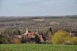
A general view of Le Menoux | |
 Le Menoux | |
|
Location within Centre-Val de Loire region  Le Menoux | |
| Coordinates: 46°33′19″N 1°34′14″E / 46.5553°N 1.5706°ECoordinates: 46°33′19″N 1°34′14″E / 46.5553°N 1.5706°E | |
| Country | France |
| Region | Centre-Val de Loire |
| Department | Indre |
| Arrondissement | Châteauroux |
| Canton | Argenton-sur-Creuse |
| Intercommunality | Pays d'Argenton-sur-Creuse |
| Government | |
| • Mayor (2008–2014) | Michel Debry |
| Area1 | 5.58 km2 (2.15 sq mi) |
| Population (2009)2 | 455 |
| • Density | 82/km2 (210/sq mi) |
| Time zone | CET (UTC+1) |
| • Summer (DST) | CEST (UTC+2) |
| INSEE/Postal code | 36117 / 36200 |
| Elevation |
108–267 m (354–876 ft) (avg. 160 m or 520 ft) |
|
1 French Land Register data, which excludes lakes, ponds, glaciers > 1 km² (0.386 sq mi or 247 acres) and river estuaries. 2 Population without double counting: residents of multiple communes (e.g., students and military personnel) only counted once. | |
Le Menoux is a commune in the Indre department in central France.
Population
| Historical population | ||
|---|---|---|
| Year | Pop. | ±% |
| 1793 | 805 | — |
| 1800 | 846 | +5.1% |
| 1806 | 835 | −1.3% |
| 1821 | 801 | −4.1% |
| 1831 | 815 | +1.7% |
| 1836 | 812 | −0.4% |
| 1841 | 828 | +2.0% |
| 1846 | 846 | +2.2% |
| 1851 | 823 | −2.7% |
| 1856 | 795 | −3.4% |
| 1861 | 801 | +0.8% |
| 1866 | 764 | −4.6% |
| 1872 | 758 | −0.8% |
| 1876 | 730 | −3.7% |
| 1881 | 748 | +2.5% |
| 1886 | 749 | +0.1% |
| 1891 | 703 | −6.1% |
| 1896 | 705 | +0.3% |
| 1901 | 746 | +5.8% |
| 1906 | 685 | −8.2% |
| 1911 | 635 | −7.3% |
| 1921 | 601 | −5.4% |
| 1926 | 582 | −3.2% |
| 1931 | 553 | −5.0% |
| 1936 | 556 | +0.5% |
| 1946 | 522 | −6.1% |
| 1954 | 508 | −2.7% |
| 1962 | 493 | −3.0% |
| 1968 | 446 | −9.5% |
| 1975 | 424 | −4.9% |
| 1982 | 434 | +2.4% |
| 1990 | 425 | −2.1% |
| 1999 | 420 | −1.2% |
| 2009 | 455 | +8.3% |
See also
References
| Wikimedia Commons has media related to Le Menoux. |
This article is issued from Wikipedia - version of the 3/15/2016. The text is available under the Creative Commons Attribution/Share Alike but additional terms may apply for the media files.