Thizay, Indre
| Thizay | |
|---|---|
|
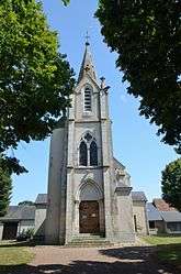
The church of Our Lady, in Thizay | |
 Thizay | |
|
Location within Centre-Val de Loire region  Thizay | |
| Coordinates: 46°53′56″N 1°54′43″E / 46.8989°N 1.9119°ECoordinates: 46°53′56″N 1°54′43″E / 46.8989°N 1.9119°E | |
| Country | France |
| Region | Centre-Val de Loire |
| Department | Indre |
| Arrondissement | Issoudun |
| Canton | Issoudun-Sud |
| Intercommunality | Champagne berrichonne |
| Government | |
| • Mayor (2008–2014) | Bernard Guillaume |
| Area1 | 16.65 km2 (6.43 sq mi) |
| Population (2009)2 | 256 |
| • Density | 15/km2 (40/sq mi) |
| Time zone | CET (UTC+1) |
| • Summer (DST) | CEST (UTC+2) |
| INSEE/Postal code | 36222 / 36100 |
| Elevation |
130–169 m (427–554 ft) (avg. 147 m or 482 ft) |
|
1 French Land Register data, which excludes lakes, ponds, glaciers > 1 km² (0.386 sq mi or 247 acres) and river estuaries. 2 Population without double counting: residents of multiple communes (e.g., students and military personnel) only counted once. | |
Thizay is a commune in the Indre department in central France.
Population
| Historical population | ||
|---|---|---|
| Year | Pop. | ±% |
| 1793 | 395 | — |
| 1800 | 413 | +4.6% |
| 1806 | 378 | −8.5% |
| 1821 | 384 | +1.6% |
| 1831 | 428 | +11.5% |
| 1836 | 477 | +11.4% |
| 1841 | 479 | +0.4% |
| 1846 | 521 | +8.8% |
| 1851 | 502 | −3.6% |
| 1856 | 512 | +2.0% |
| 1861 | 530 | +3.5% |
| 1866 | 570 | +7.5% |
| 1872 | 538 | −5.6% |
| 1876 | 528 | −1.9% |
| 1881 | 500 | −5.3% |
| 1886 | 530 | +6.0% |
| 1891 | 515 | −2.8% |
| 1896 | 469 | −8.9% |
| 1901 | 462 | −1.5% |
| 1906 | 446 | −3.5% |
| 1911 | 448 | +0.4% |
| 1921 | 380 | −15.2% |
| 1926 | 370 | −2.6% |
| 1931 | 335 | −9.5% |
| 1936 | 318 | −5.1% |
| 1946 | 335 | +5.3% |
| 1954 | 370 | +10.4% |
| 1962 | 368 | −0.5% |
| 1968 | 300 | −18.5% |
| 1975 | 262 | −12.7% |
| 1982 | 245 | −6.5% |
| 1990 | 220 | −10.2% |
| 1999 | 250 | +13.6% |
| 2006 | 255 | +2.0% |
| 2009 | 256 | +0.4% |
See also
References
| Wikimedia Commons has media related to Thizay (Indre). |
This article is issued from Wikipedia - version of the 2/9/2015. The text is available under the Creative Commons Attribution/Share Alike but additional terms may apply for the media files.