Villegouin
| Villegouin | |
|---|---|
|
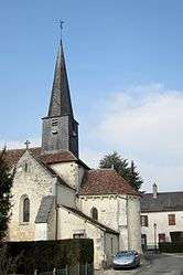
The church of Our Lady, in Villegouin | |
 Villegouin | |
|
Location within Centre-Val de Loire region  Villegouin | |
| Coordinates: 46°57′54″N 1°22′26″E / 46.965°N 1.3739°ECoordinates: 46°57′54″N 1°22′26″E / 46.965°N 1.3739°E | |
| Country | France |
| Region | Centre-Val de Loire |
| Department | Indre |
| Arrondissement | Châteauroux |
| Canton | Écueillé |
| Intercommunality | Pays d'Écueillé |
| Government | |
| • Mayor (2008–2014) | Claude Moreau |
| Area1 | 24.03 km2 (9.28 sq mi) |
| Population (2009)2 | 404 |
| • Density | 17/km2 (44/sq mi) |
| Time zone | CET (UTC+1) |
| • Summer (DST) | CEST (UTC+2) |
| INSEE/Postal code | 36243 / 36500 |
| Elevation |
101–201 m (331–659 ft) (avg. 125 m or 410 ft) |
|
1 French Land Register data, which excludes lakes, ponds, glaciers > 1 km² (0.386 sq mi or 247 acres) and river estuaries. 2 Population without double counting: residents of multiple communes (e.g., students and military personnel) only counted once. | |
Villegouin is a commune in the Indre department in central France.
Geography
The Indrois has its source in the commune.
Population
| Historical population | ||
|---|---|---|
| Year | Pop. | ±% |
| 1793 | 580 | — |
| 1800 | 614 | +5.9% |
| 1806 | 649 | +5.7% |
| 1821 | 797 | +22.8% |
| 1831 | 876 | +9.9% |
| 1836 | 801 | −8.6% |
| 1841 | 759 | −5.2% |
| 1846 | 823 | +8.4% |
| 1851 | 805 | −2.2% |
| 1856 | 796 | −1.1% |
| 1861 | 832 | +4.5% |
| 1866 | 873 | +4.9% |
| 1872 | 845 | −3.2% |
| 1876 | 867 | +2.6% |
| 1881 | 838 | −3.3% |
| 1886 | 813 | −3.0% |
| 1891 | 845 | +3.9% |
| 1896 | 812 | −3.9% |
| 1901 | 794 | −2.2% |
| 1906 | 785 | −1.1% |
| 1911 | 800 | +1.9% |
| 1921 | 665 | −16.9% |
| 1926 | 692 | +4.1% |
| 1931 | 625 | −9.7% |
| 1936 | 622 | −0.5% |
| 1946 | 572 | −8.0% |
| 1954 | 579 | +1.2% |
| 1962 | 541 | −6.6% |
| 1968 | 521 | −3.7% |
| 1975 | 456 | −12.5% |
| 1982 | 401 | −12.1% |
| 1990 | 410 | +2.2% |
| 1999 | 411 | +0.2% |
| 2006 | 403 | −1.9% |
| 2009 | 404 | +0.2% |
See also
References
| Wikimedia Commons has media related to Villegouin. |
This article is issued from Wikipedia - version of the 2/9/2015. The text is available under the Creative Commons Attribution/Share Alike but additional terms may apply for the media files.