Montchevrier
| Montchevrier | |
|---|---|
|
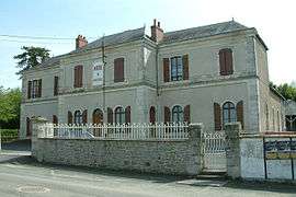
The town hall in Montchevrier | |
 Montchevrier | |
|
Location within Centre-Val de Loire region  Montchevrier | |
| Coordinates: 46°28′53″N 1°44′36″E / 46.4814°N 1.7433°ECoordinates: 46°28′53″N 1°44′36″E / 46.4814°N 1.7433°E | |
| Country | France |
| Region | Centre-Val de Loire |
| Department | Indre |
| Arrondissement | La Châtre |
| Canton | Aigurande |
| Intercommunality | Marche berrichonne |
| Government | |
| • Mayor (2008–2014) | Jean-Marc Hemery |
| Area1 | 34.7 km2 (13.4 sq mi) |
| Population (2009)2 | 506 |
| • Density | 15/km2 (38/sq mi) |
| Time zone | CET (UTC+1) |
| • Summer (DST) | CEST (UTC+2) |
| INSEE/Postal code | 36126 / 36140 |
| Elevation |
230–397 m (755–1,302 ft) (avg. 366 m or 1,201 ft) |
|
1 French Land Register data, which excludes lakes, ponds, glaciers > 1 km² (0.386 sq mi or 247 acres) and river estuaries. 2 Population without double counting: residents of multiple communes (e.g., students and military personnel) only counted once. | |
Montchevrier is a commune in the Indre department in central France.
Geography
The commune is traversed by the river Bouzanne.
Population
| Historical population | ||
|---|---|---|
| Year | Pop. | ±% |
| 1793 | 920 | — |
| 1800 | 818 | −11.1% |
| 1806 | 883 | +7.9% |
| 1821 | 1,019 | +15.4% |
| 1831 | 1,123 | +10.2% |
| 1836 | 1,242 | +10.6% |
| 1841 | 1,225 | −1.4% |
| 1846 | 1,247 | +1.8% |
| 1851 | 1,340 | +7.5% |
| 1856 | 1,350 | +0.7% |
| 1861 | 1,302 | −3.6% |
| 1866 | 1,293 | −0.7% |
| 1872 | 1,216 | −6.0% |
| 1876 | 1,238 | +1.8% |
| 1881 | 1,272 | +2.7% |
| 1886 | 1,384 | +8.8% |
| 1891 | 1,439 | +4.0% |
| 1896 | 1,412 | −1.9% |
| 1901 | 1,380 | −2.3% |
| 1906 | 1,418 | +2.8% |
| 1911 | 1,395 | −1.6% |
| 1921 | 1,236 | −11.4% |
| 1926 | 1,239 | +0.2% |
| 1931 | 1,226 | −1.0% |
| 1936 | 1,226 | +0.0% |
| 1946 | 1,158 | −5.5% |
| 1954 | 1,146 | −1.0% |
| 1962 | 1,082 | −5.6% |
| 1968 | 987 | −8.8% |
| 1975 | 836 | −15.3% |
| 1982 | 760 | −9.1% |
| 1990 | 631 | −17.0% |
| 1999 | 537 | −14.9% |
| 2009 | 506 | −5.8% |
See also
References
| Wikimedia Commons has media related to Montchevrier. |
This article is issued from Wikipedia - version of the 2/9/2015. The text is available under the Creative Commons Attribution/Share Alike but additional terms may apply for the media files.