Villegongis
| Villegongis | |
|---|---|
|
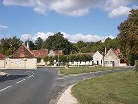
The centre of Villegongis, with the town hall, the hall, the church, the well and the inn | |
 Villegongis | |
|
Location within Centre-Val de Loire region  Villegongis | |
| Coordinates: 46°54′51″N 1°35′47″E / 46.9142°N 1.5964°ECoordinates: 46°54′51″N 1°35′47″E / 46.9142°N 1.5964°E | |
| Country | France |
| Region | Centre-Val de Loire |
| Department | Indre |
| Arrondissement | Châteauroux |
| Canton | Levroux |
| Intercommunality | Région de Levroux |
| Government | |
| • Mayor (2008–2014) | Jean Marc Sevault |
| Area1 | 18.15 km2 (7.01 sq mi) |
| Population (2009)2 | 139 |
| • Density | 7.7/km2 (20/sq mi) |
| Time zone | CET (UTC+1) |
| • Summer (DST) | CEST (UTC+2) |
| INSEE/Postal code | 36242 / 36110 |
| Elevation |
141–196 m (463–643 ft) (avg. 159 m or 522 ft) |
|
1 French Land Register data, which excludes lakes, ponds, glaciers > 1 km² (0.386 sq mi or 247 acres) and river estuaries. 2 Population without double counting: residents of multiple communes (e.g., students and military personnel) only counted once. | |
Villegongis is a commune in the Indre department in central France.
Population
| Historical population | ||
|---|---|---|
| Year | Pop. | ±% |
| 1793 | 196 | — |
| 1800 | 219 | +11.7% |
| 1806 | 220 | +0.5% |
| 1821 | 255 | +15.9% |
| 1831 | 350 | +37.3% |
| 1836 | 380 | +8.6% |
| 1841 | 450 | +18.4% |
| 1846 | 495 | +10.0% |
| 1851 | 305 | −38.4% |
| 1856 | 297 | −2.6% |
| 1861 | 236 | −20.5% |
| 1866 | 227 | −3.8% |
| 1872 | 192 | −15.4% |
| 1876 | 219 | +14.1% |
| 1881 | 222 | +1.4% |
| 1886 | 214 | −3.6% |
| 1891 | 220 | +2.8% |
| 1896 | 214 | −2.7% |
| 1901 | 222 | +3.7% |
| 1906 | 208 | −6.3% |
| 1911 | 188 | −9.6% |
| 1921 | 188 | +0.0% |
| 1926 | 192 | +2.1% |
| 1931 | 182 | −5.2% |
| 1936 | 152 | −16.5% |
| 1946 | 177 | +16.4% |
| 1954 | 188 | +6.2% |
| 1962 | 195 | +3.7% |
| 1968 | 138 | −29.2% |
| 1975 | 117 | −15.2% |
| 1982 | 130 | +11.1% |
| 1990 | 111 | −14.6% |
| 1999 | 101 | −9.0% |
| 2006 | 140 | +38.6% |
| 2009 | 139 | −0.7% |
See also
References
| Wikimedia Commons has media related to Villegongis. |
This article is issued from Wikipedia - version of the 2/9/2015. The text is available under the Creative Commons Attribution/Share Alike but additional terms may apply for the media files.