List of counties in Arkansas
| Counties of Arkansas | |
|---|---|
| Location | State of Arkansas |
| Number | 75 |
| Populations | 5,368 (Calhoun) – 382,748 (Pulaski) |
| Areas | 526 square miles (1,360 km2) (Lafayette) – 1,039 square miles (2,690 km2) (Union) |
| Government | County government |
| Subdivisions | cities, towns, townships, unincorporated communities, census designated place |
| Part of a series on |
| Regions of Arkansas |
|---|
 |
|
Geographic Regions |
|
Administrative divisions
|
There are 75 counties in the U.S. state of Arkansas.[1] Arkansas is tied with Mississippi for the most counties with two county seats, at ten.
Counties
| County |
FIPS County Code |
County seat [1] |
Established [1] |
Origin |
Etymology |
Population [1] |
Area [1] |
Map |
|---|---|---|---|---|---|---|---|---|
| Arkansas County | 001 | De Witt and Stuttgart | 1813 | 1st County (Eastern Arkansas) | A variant pronunciation of the Quapaw Native American people | 19,019 | 988 sq mi (2,559 km2) | 
|
| Ashley County | 003 | Hamburg | 1848 | Chicot, Drew and Union counties | Chester Ashley (1791–1848), a U.S. Senator from Arkansas | 21,853 | 921 sq mi (2,385 km2) | 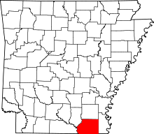
|
| Baxter County | 005 | Mountain Home | 1873 | Fulton, Izard, Marion, and Searcy counties | Elisha Baxter (1827–1899), a Governor of Arkansas | 41,513 | 554 sq mi (1,435 km2) | 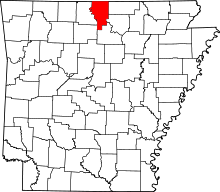
|
| Benton County | 007 | Bentonville | 1836 | Washington County | Thomas Hart Benton (1782–1858), a U.S. Senator from Missouri | 221,339 | 843 sq mi (2,183 km2) | 
|
| Boone County | 009 | Harrison | 1869 | Carroll and Marion counties | Daniel Boone (1734–1820), the American frontiersman | 36,903 | 591 sq mi (1,531 km2) | 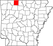
|
| Bradley County | 011 | Warren | 1840 | Union County | Hugh Bradley, a soldier in the War of 1812 and early area settler | 11,508 | 651 sq mi (1,686 km2) | 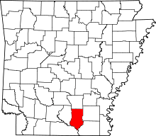
|
| Calhoun County | 013 | Hampton | 1850 | Dallas and Ouachita counties | John C. Calhoun (1782–1850), 7th Vice President of the United States and a Senator from South Carolina | 5,368 | 628 sq mi (1,627 km2) | 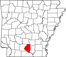
|
| Carroll County | 015 | Berryville and Eureka Springs | 1833 | Izard County and later by Madison County (1870) | Charles Carroll of Carrollton (1737–1832), a signer of the Declaration of Independence | 27,446 | 634 sq mi (1,642 km2) | 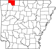
|
| Chicot County | 017 | Lake Village | 1823 | Arkansas County | Point Chicot on the Mississippi River | 11,800 | 644 sq mi (1,668 km2) | 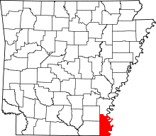
|
| Clark County | 019 | Arkadelphia | 1818 | Arkansas (1818) | William Clark (1770–1838), explorer and Governor of the Missouri Territory | 22,995 | 866 sq mi (2,243 km2) | 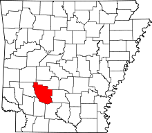
|
| Clay County | 021 | Piggott and Corning | 1873 | Randolph and Greene counties, and originally named Clayton before 1875 | John Clayton, a State Senator; later shortened to Clay to avoid misassociation with Powell Clayton |
16,083 | 639 sq mi (1,655 km2) | 
|
| Cleburne County | 023 | Heber Springs | 1883 | White, Van Buren, and Independence counties | Patrick Cleburne (1828–1864), a Confederate General in the Civil War | 25,970 | 553 sq mi (1,432 km2) | 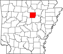
|
| Cleveland County | 025 | Rison | 1873 | Bradley, Dallas, Jefferson counties, and formerly named Dorsey County (from 1885) | Grover Cleveland (1837–1908), 22nd and 24th President of the United States (formerly Stephen Dorsey, U.S. Senator from Arkansas) |
8,689 | 598 sq mi (1,549 km2) | 
|
| Columbia County | 027 | Magnolia | 1852 | Formed from Lafayette, Hempstead, and Ouachita counties | Columbia, a female personification of the United States | 24,552 | 766 sq mi (1,984 km2) | 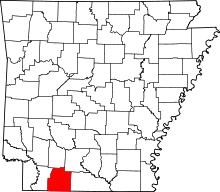
|
| Conway County | 029 | Morrilton | 1825 | Pulaski County | Henry Wharton Conway (1793–1827), territorial delegate to the United States House of Representatives | 21,273 | 556 sq mi (1,440 km2) | 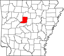
|
| Craighead County | 031 | Jonesboro and Lake City | 1859 | Mississippi, Greene, Poinsett counties | Thomas Craighead (1798–1862), a State Senator who ironically opposed the creation of the county | 96,443 | 711 sq mi (1,841 km2) | 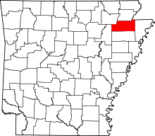
|
| Crawford County | 033 | Van Buren | 1820 | Pulaski County | William H. Crawford (1772–1834), a politician who served as Secretary of the Treasury and Secretary of War | 61,948 | 596 sq mi (1,544 km2) | 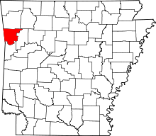
|
| Crittenden County | 035 | Marion | 1825 | Phillips County | Robert Crittenden (1797–1834), Governor of the Arkansas Territory | 50,902 | 610 sq mi (1,580 km2) | 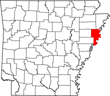
|
| Cross County | 037 | Wynne | 1862 | St. Francis, Poinsett, and Crittenden counties | David C. Cross, a Confederate soldier in the Civil War and local politician | 17,870 | 616 sq mi (1,595 km2) | 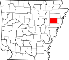
|
| Dallas County | 039 | Fordyce | 1845 | Clark and Bradley counties | George M. Dallas (1792–1864), 11th Vice President of the United States | 8,116 | 668 sq mi (1,730 km2) | 
|
| Desha County | 041 | Arkansas City | 1838 | Arkansas, Union counties, then from Chicot County (prior to 1880), and Lincoln (prior 1930) | Benjamin Desha, a soldier in the War of 1812 | 13,008 | 765 sq mi (1,981 km2) | 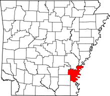
|
| Drew County | 043 | Monticello | 1846 | Bradley, Chicot, Desha, Union counties | Thomas Stevenson Drew (1802–1879), 3rd Governor of Arkansas | 18,509 | 828 sq mi (2,145 km2) | 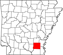
|
| Faulkner County | 045 | Conway | 1873 | Pulaski and Conway counties | Sanford Faulkner (1806–1874), a Confederate soldier and the composer of the song "The Arkansas Traveler" | 113,237 | 647 sq mi (1,676 km2) | 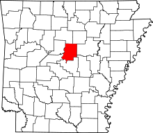
|
| Franklin County | 047 | Ozark and Charleston | 1837 | Crawford and Johnson counties | Benjamin Franklin (1706–1790), founding father of the United States | 18,125 | 610 sq mi (1,580 km2) | 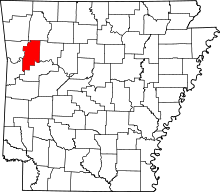
|
| Fulton County | 049 | Salem | 1842 | Izard County and then later from Lawrence County (prior 1850) | William Savin Fulton (1795–1844), the last Governor of the Arkansas Territory prior to statehood | 12,245 | 618 sq mi (1,601 km2) | 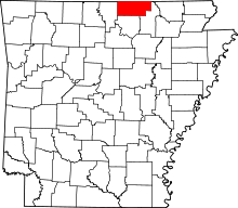
|
| Garland County | 051 | Hot Springs | 1873 | Montgomery, Hot Spring, and Saline counties | Augustus Hill Garland (1832–1899), U.S. Senator and 11th Governor of Arkansas | 96,024 | 678 sq mi (1,756 km2) | 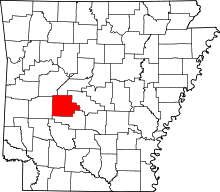
|
| Grant County | 053 | Sheridan | 1869 | Jefferson, Hot Spring, Saline counties | Ulysses Simpson Grant (1822–1885), 18th President of the United States | 17,853 | 632 sq mi (1,637 km2) | 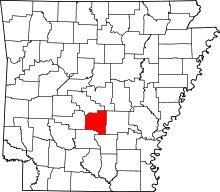
|
| Greene County | 055 | Paragould | 1833 | Lawrence County and later on by Randolph | Nathanael Greene (1742–1786), the Revolutionary War General | 42,090 | 578 sq mi (1,497 km2) | 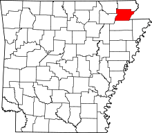
|
| Hempstead County | 057 | Hope | 1818 | Arkansas (1818) | Edward Hempstead (1780–1817), Delegate to the U.S. House of Representatives from the Missouri Territory | 22,609 | 729 sq mi (1,888 km2) | 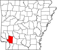
|
| Hot Spring County | 059 | Malvern | 1829 | Clark County and later from Montgomery County (prior 1880) | Naturally occurring hot springs within the county | 32,923 | 615 sq mi (1,593 km2) | 
|
| Howard County | 061 | Nashville | 1873 | Pike, Hempstead, Polk, Sevier counties. | James H. Howard, an Arkansas State Senator | 13,789 | 588 sq mi (1,523 km2) | 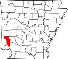
|
| Independence County | 063 | Batesville | 1820 | Lawrence County (1820) | The Declaration of Independence | 36,647 | 764 sq mi (1,979 km2) | 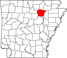
|
| Izard County | 065 | Melbourne | 1825 | Independence, Crawford counties, and later from Fulton (prior 1880) | George Izard (1776–1828), Governor of the Missouri Territory and a General during the War of 1812 | 13,696 | 581 sq mi (1,505 km2) | 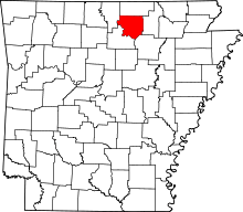
|
| Jackson County | 067 | Newport | 1829 | Lawrence and St. Francis counties | Andrew Jackson (1767–1845), 7th President of the United States | 17,997 | 634 sq mi (1,642 km2) | 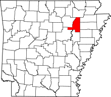
|
| Jefferson County | 069 | Pine Bluff | 1829 | Arkansas and Pulaski | Thomas Jefferson (1743–1826), 3rd President of the United States | 77,435 | 885 sq mi (2,292 km2) | 
|
| Johnson County | 071 | Clarksville | 1833 | Pope County, and a small portion from Madison County (prior 1890) | Benjamin Johnson (1784–1849), the first judge of the federal district court for Arkansas | 25,540 | 662 sq mi (1,715 km2) | 
|
| Lafayette County | 073 | Lewisville | 1827 | Hempstead County and later from Columbia County (prior 1910) | Gilbert du Motier, marquis de Lafayette (1757–1834), a Frenchman who served as a General in the Continental Army during the Revolutionary War | 7,645 | 526 sq mi (1,362 km2) | 
|
| Lawrence County | 075 | Walnut Ridge | 1815 | Arkansas and New Madrid (MO) in 1815 | James Lawrence (1781–1813), an American naval officer during the War of 1812 | 17,415 | 587 sq mi (1,520 km2) | 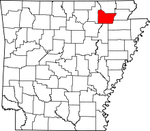
|
| Lee County | 077 | Marianna | 1873 | Phillips, Monroe, Crittenden, and St. Francis counties. | Robert E. Lee (1807–1870), a confederate General during the Civil War | 10,424 | 602 sq mi (1,559 km2) | 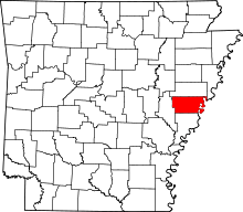
|
| Lincoln County | 079 | Star City | 1871 | Arkansas, Bradley, Desha, Drew, and Jefferson counties | Abraham Lincoln (1809–1865), 16th President of the United States | 14,134 | 561 sq mi (1,453 km2) | 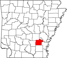
|
| Little River County | 081 | Ashdown | 1867 | Sevier County | Little River, a tributary of the Red River | 13,171 | 532 sq mi (1,378 km2) | 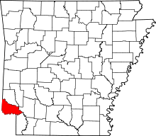
|
| Logan County | 083 | Booneville and Paris | 1871 | Franklin, Johnson, Pope, Scott, and Yell counties (Formally named Sarber County) | James Logan (1791–1859), an early settler of western Arkansas | 22,353 | 710 sq mi (1,839 km2) | 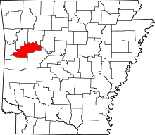
|
| Lonoke County | 085 | Lonoke | 1873 | Prairie and Pulaski counties | An oak tree that stood on the site of the current county seat | 68,356 | 766 sq mi (1,984 km2) | 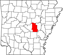
|
| Madison County | 087 | Huntsville | 1836 | Washington County | James Madison (1751–1836), 4th President of the United States | 15,717 | 837 sq mi (2,168 km2) | 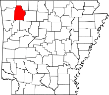
|
| Marion County | 089 | Yellville | 1835 | Izard County | Francis Marion (1732–1795), an American general during the Revolutionary War | 16,653 | 598 sq mi (1,549 km2) | 
|
| Miller County | 091 | Texarkana | 1874 | Lafayette County | Former Miller County, Arkansas Territory (1820-38), which was named for James Miller (1776–1851), first Governor of the Arkansas Territory |
43,462 | 624 sq mi (1,616 km2) | 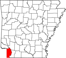
|
| Mississippi County | 093 | Blytheville and Osceola | 1833[2] | Crittenden | the Mississippi River | 46,480 | 920 sq mi (2,383 km2) | 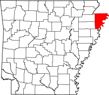
|
| Monroe County | 095 | Clarendon | 1829[3] | Phillips and Arkansas counties | James Monroe (1758–1831), 5th President of the United States | 8,149 | 607 sq mi (1,572 km2) | 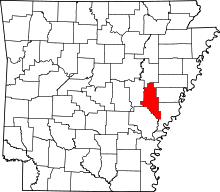
|
| Montgomery County | 097 | Mount Ida | 1842 | Hot Spring | Richard Montgomery (1738–1775), an American general during the Revolutionary War | 9,487 | 781 sq mi (2,023 km2) | 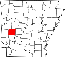
|
| Nevada County | 099 | Prescott | 1871 | Columbia, Hempstead, Ouachita counties | the state of Nevada | 8,997 | 620 sq mi (1,606 km2) | 
|
| Newton County | 101 | Jasper | 1842 | Carroll | Thomas W. Newton (1804–1853), a State Senator and member of the United States House of Representatives from Arkansas | 8,330 | 823 sq mi (2,132 km2) | 
|
| Ouachita County | 103 | Camden | 1842 | Union | the Ouachita River | 26,120 | 732 sq mi (1,896 km2) | 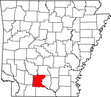
|
| Perry County | 105 | Perryville | 1840 | Conway County | Oliver Hazard Perry (1785–1819), a naval officer in the War of 1812 | 10,445 | 551 sq mi (1,427 km2) | 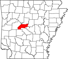
|
| Phillips County | 107 | Helena | 1820 | Arkansas and Lawrence County | Sylvanus Phillips, a member of the territorial legislature | 21,757 | 693 sq mi (1,795 km2) | 
|
| Pike County | 109 | Murfreesboro | 1833 | Clark and Hempstead counties | Zebulon Pike (1779–1813), the explorer and discoverer of Pikes Peak | 11,291 | 603 sq mi (1,562 km2) | 
|
| Poinsett County | 111 | Harrisburg | 1838 | Greene, Lawrence counties | Joel Roberts Poinsett (1779–1851), a United States Secretary of War and namesake of the poinsettia | 24,583 | 758 sq mi (1,963 km2) | 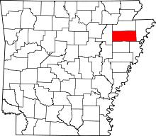
|
| Polk County | 113 | Mena | 1844 | Sevier | James Knox Polk (1795–1849), the eleventh president of the United States | 20,662 | 860 sq mi (2,227 km2) | 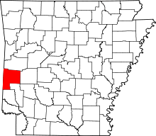
|
| Pope County | 115 | Russellville | 1829 | Crawford County | John Pope (1770–1845), a governor of the Arkansas Territory | 61,754 | 812 sq mi (2,103 km2) | 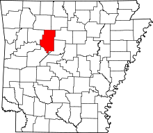
|
| Prairie County | 117 | Des Arc and DeValls Bluff | 1846 | Arkansas and Pulaski counties | Grand Prairie of eastern Arkansas | 8,715 | 646 sq mi (1,673 km2) | 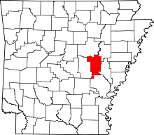
|
| Pulaski County | 119 | Little Rock | 1818 | Arkansas and Lawrence counties (1818) | Kazimierz Pulaski (1745–1779), the Polish general in the American Revolutionary War | 382,748 | 771 sq mi (1,997 km2) | 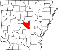
|
| Randolph County | 121 | Pocahontas | 1835 | Lawrence County | John Randolph of Roanoke (1773–1833), a U.S. congressman from Virginia | 17,969 | 652 sq mi (1,689 km2) | 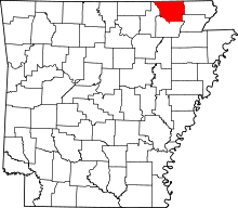
|
| St. Francis County | 123 | Forrest City | 1827 | Formed from Phillips County | The St. Francis River, a tributary of the Mississippi River | 28,258 | 634 sq mi (1,642 km2) | 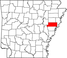
|
| Saline County | 125 | Benton | 1835 | Independence and Pulaski | Salt reserves found within its borders | 107,118 | 725 sq mi (1,878 km2) | 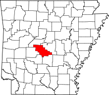
|
| Scott County | 127 | Waldron | 1833 | Crawford and Pope counties | Andrew Scott (1789–1841), a territorial judge | 11,233 | 894 sq mi (2,315 km2) | 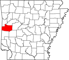
|
| Searcy County | 129 | Marshall | 1838 | Marion County | Richard Searcy, a judge from Lawrence County | 8,195 | 667 sq mi (1,728 km2) | 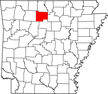
|
| Sebastian County | 131 | Greenwood and Fort Smith | 1851 | Crawford and Scott | William K. Sebastian (1812–1865), a U.S. Circuit Court judge from Arkansas | 125,744 | 536 sq mi (1,388 km2) | 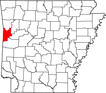
|
| Sevier County | 133 | De Queen | 1828 | Hempstead County | Ambrose Sevier (1801–1848), a U.S. Senator from Arkansas | 17,058 | 564 sq mi (1,461 km2) | 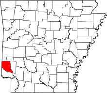
|
| Sharp County | 135 | Ash Flat | 1868 | Lawrence County | Ephraim Sharp, an early settler of Arkansas | 17,264 | 604 sq mi (1,564 km2) | 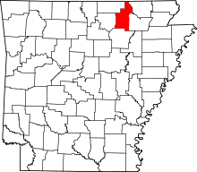
|
| Stone County | 137 | Mountain View | 1873 | Izard, Independence, Searcy, Van Buren | Rugged, rocky area terrain | 12,394 | 607 sq mi (1,572 km2) | 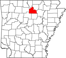
|
| Union County | 139 | El Dorado | 1829 | Clark and Hempstead counties | The concept of the union of the states | 41,639 | 1,039 sq mi (2,691 km2) | 
|
| Van Buren County | 141 | Clinton | 1833 | Conway, Izard, and Independence | Martin Van Buren (1782–1862), eighth president of the United States | 17,295 | 712 sq mi (1,844 km2) | 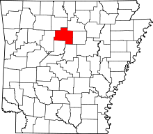
|
| Washington County | 143 | Fayetteville | 1828 | Lovely County | George Washington (1732–1799), first president of the United States | 203,065 | 950 sq mi (2,460 km2) | 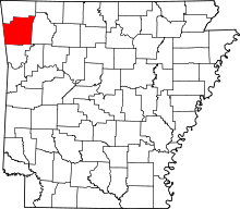
|
| White County | 145 | Searcy | 1835 | Independence, Jackson and Pulaski counties | Hugh L. White (1773–1840), U.S. Senator from Tennessee and U.S. presidential candidate in 1836 for the Whig Party | 77,076 | 1,034 sq mi (2,678 km2) | 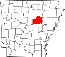
|
| Woodruff County | 147 | Augusta | 1862 | Jackson and St. Francis counties | William Woodruff (1795–1885), the first newspaper publisher in Arkansas | 7,260 | 587 sq mi (1,520 km2) | 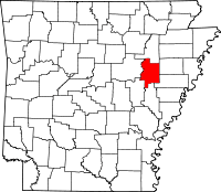
|
| Yell County | 149 | Danville and Dardanelle | 1840 | Hot Spring, Pope, and Scott County | Archibald Yell (1797–1847), the second governor of Arkansas | 22,185 | 928 sq mi (2,404 km2) | 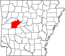 |
Former counties in Arkansas
Lovely County (1827–1828)
Created on October 13, 1827, partitioned from Crawford County. The Treaty of Washington, 1828 ceded most of its territory to Indian Territory. Abolished October 17, 1828 with the remaining portion becoming Washington County.[4]
Miller County, Arkansas Territory (1820-38)
Created from Hempstead County. Most of its northern portion was actually in Choctaw Nation (now part of Oklahoma); rest of northern portion was dissolved into Sevier County in 1828. All of its southern portion was actually in Texas, and was nominally dissolved into Lafayette County in 1838.
Fictional counties in Arkansas
Bogan County
A fictional county in Arkansas as portrayed in the movie White Lightning and in the movie Dark Night of the Scarecrow.
Deeson County
A fictional county in southwest Arkansas near the intersection of Highway 71 and Interstate 82 as portrayed in the movie Smokey and the Bandit.
Green River County
A fictional county in Arkansas portrayed in the series Supernatural. Sam and Dean are arrested in Little Rock (which is actually located in Pulaski County), but they are sent to Green River County Detention.
References
- 1 2 3 4 5 "Find A County". National Association of Counties. Retrieved 2012-04-07.
- ↑ Mississippi County, Arkansas county government. "Mississippi County History". Retrieved 2011-04-15.
- ↑ Goodspeed, Weston Arthur, ed. (1904). The Province and the States: A History of the Province of Louisiana Under France and Spain, and of the Territories and States of the United States Formed Therefrom. VII. Madison, WI: The Western Historical Association. p. 107. Retrieved 2012-05-09.
- ↑ McConaughy, James. "Lovely County, Arkansas". Washington County Arkansas Genealogical Society (WCAGS). Retrieved 2012-05-08.