Microregion of Auriflama
| Microregion of Auriflama | |
|---|---|
| Microregion | |
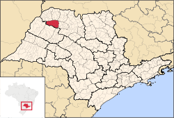 Location of the Microregion of Auriflama | |
| Coordinates: 20°41′09″S 50°33′18″W / 20.68583°S 50.55500°WCoordinates: 20°41′09″S 50°33′18″W / 20.68583°S 50.55500°W | |
| Country |
|
| Region | Southeast |
| State |
|
| Mesoregion | São José do Rio Preto |
| Area | |
| • Total | 2,312.2 km2 (892.7 sq mi) |
| Population (2010/IBGE) | |
| • Total | 46,367 |
| • Density | 20/km2 (52/sq mi) |
| Time zone | UTC-3 (UTC-3) |
| • Summer (DST) | UTC-2 (UTC-2) |
| Postal Code | 15350-000 |
| Area code(s) | +55 17 |
The Microregion of Auriflama (Portuguese: Microrregião de Auriflama) is located on the northwest of São Paulo state, Brazil, and is made up of 9 municipalities. It belongs to the Mesoregion of São José do Rio Preto.
The microregion has a population of 46,367 inhabitants, in an area of 2,312.2 km²[1]
Municipalities
The microregion consists of the following municipalities,[2] listed below with their 2010 Census populations (IBGE/2010):[3]
- Auriflama: 14,202
- Floreal: 3,003
- Gastão Vidigal: 4,193
- General Salgado: 10,699
- Guzolândia: 4,754
- Magda: 3,200
- Nova Castilho: 1,125
- Nova Luzitânia: 3,441
- São João de Iracema: 1,780
References
- ↑ "2010 Census of the IBGE - Synopsis - Tables 761 and 1301" (in Portuguese). IBGE.gov.br. Retrieved 13 July 2011.
- ↑ Instituto Brasileiro de Geografia e Estatística, territorial division.
- ↑ "2010 Census of the IBGE - Population - Table 2.1.20" (PDF). IBGE.gov.br. Retrieved 13 July 2011.
| Mesoregions |
|
|---|---|
| Microregions |
|
This article is issued from Wikipedia - version of the 11/5/2016. The text is available under the Creative Commons Attribution/Share Alike but additional terms may apply for the media files.