Nallamala Hills
| Nallamala Hills నల్లమల్ల కొండలు | |
|---|---|
| The Nallamalas | |
|
The Nallamalas Hills | |
| Highest point | |
| Peak | Bhairani Konda (Sikhareswaram) |
| Elevation | 3,608 ft (1,100 m) |
| Coordinates | 15°40′41″N 78°47′10″E / 15.67806°N 78.78611°ECoordinates: 15°40′41″N 78°47′10″E / 15.67806°N 78.78611°E |
| Dimensions | |
| Length | 90 mi (140 km) north-south |
| Geography | |
| Country | India |
| Provinces/States | Andhra Pradesh and Telangana |
| Geology | |
| Age of rock | Proterozoic |
The Nallamalas (also called the Nallamalla Range) are a section of the Eastern Ghats which stretch primarily over Kurnool, Nellore, Guntur, Prakasam, Kadapa and Chittoor districts of the state of Andhra Pradesh and Mahabubnagar, Nalgonda districts of the state of Telangana, in India. They run in a nearly north-south alignment, parallel to the Coromandel Coast for close to 430 km between the rivers, Krishna and Pennar. Its northern boundaries are marked by the flat Palnadu basin while in the south it merges with the Tirupati hills. An extremely old system, the hills have extensively weathered and eroded over the years. The average elevation today is about 520 m which reaches 1100 m at Bhairani Konda and 1048 m at Gundla Brahmeswara.[1] Both of these peaks are in a north westerly direction from the town of Cumbum. There are also many other peaks above 800 m.[2]
Geology
The rocks of the Nallamala ranges belong to the Kadapa system which is a series some 20,000 ft. thick.[3] The primary rocks are Quartzite overlaid with an irregular slaty formation. Some sandstone is also to be found. The rocks here are very irregular and soft in texture thus rendering commercial exploitation impossible. These rocks are among the oldest in the world and have been formed as a result of large scale volcanic activity hundreds of millions of years ago. The evidence of the volcanic forces are evident in the foldings into which the rocks have been forced, in some cases the folds have been completely inverted.[2]
Climate
The Nallamalas have a rather warm to hot climate throughout the year. Rainfall averages about 90 cm and is concentrated in the months of the South West Monsoon (June–September). The fissured rocks prevent any water from percolating underground and hence most of the discharge runs off as mountain streams to join the Gundlakamma River, the largest river to arise in these hills. Winters are mostly cool and dry with the average temperature around 25 degrees Celsius.
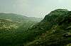
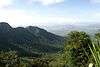
Image Gallery
 Nallamalla forests at Srisailam
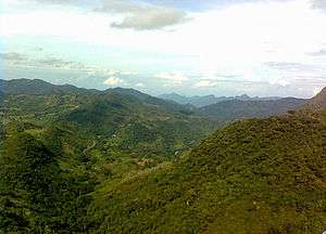
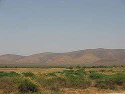 The Nallamallas from a distance during the dry season
 Sunflower cultivation at the foot of Cumbum at the Nallamalas
 After noon in Nallamalla Forest
 The railway curves into the Nallamalas at the Nandikamma Pass, Cumbum
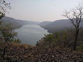
 A view of the Cumbum Lake
 Nallamalla forests at Ahobilam
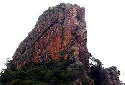 Ugra stambham rock at Ahobilam
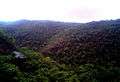 Nallamalla hills on rainy day near Atmakur
 Chenchu tribal hunting picture from Nallamala Hills
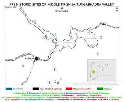 Pre Historic Mid Krishna-Tungabhadra Valley sites
 Morning in Nallamalla Forest
 Tribals staying in Nallamalla Forest
 view on Sun set time
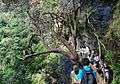 Trek to Ugra stambham at Ahobilam in Nallamala Forests
 View From Boat Journey towards caves
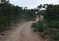 Dirt road along Nallamala Forests near Ahobilam
Geography and land use
These hills are almost completely covered with open jungle. Lack of water prevents the growth of large trees and the prevalent vegetation consists of Terminalia, Hardwickia and Pterocarpus. Agriculture is almost non existent apart from isolated patches near villages where subsistence farming is practiced. The Nallamala Forests are probably the largest stretch of undisturbed forest in South India apart from the Western Ghats and were particularly rich in game till the 1970s. A large part of the forest is a part of the Nagarjunsagar-Srisailam Tiger Reserve that has a viable tiger population. Leopard sightings too are not uncommon. Many of the adventures of the popular wildlife writer, Kenneth Anderson are set in these forests.[4]
Population
The uneven terrain and the scarcity of water has prevented the growth of any large cities in this region. Nandyal is the largest town in this area and giddalur is the second largest town near by it. The indigenous population consists of the Chenchus, a forest dwelling tribe who have remained cut off from the modern world even today. Farming is the primary occupation of the people in the plateaus while the Chenchus are still hunter gatherers. The hills were a hotbed of Naxal activities until recently. Police action since 2005 has all but cleared the forest of them.
Transport
A state highway and the Vijayawada-Guntakal line of the South Central Railway pass through the hills. The railway was first built by the Madras and Southern Mahratta Railway and is a feat of engineering, having 2 tunnels at Bogada and Chelama and a few viaducts, the most famous being the now abandoned Dorabavi Viaduct. The railway enters the hills at the Nandikama Pass near Cumbum Lake. The highway follows a zig zag alignment and thus avoids any tunnels. The primary exports of this region are forest produce like timber waste, honey and molasses.
Places of interest
Srisailam on the River Krishna is the site of a large hydroelectric power project as also an ancient and much revered temple dedicated to Lord Shiva.
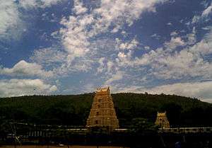
Mahanandi temple and Ahobilam Nava Narsimha Temples are situated here.
A stream descends down the Gundla Brahmeswara peak and ends in a beautiful waterfall and sacred pool called Nemaligundam (Peacock Pool).
The Mallela Theertham waterfall on the river Krishna is also located in this forest.
The Cumbum Lake is one of Asia's oldest man made lakes and dates back to the 15th century. It was built by the Gajapati kings of Orissa for irrigating about 420 km2 farmland by damming a narrow opening between two adjoining hills and later renovated by queen Vardarajamma of Vijayanagara kingdom in the 16th Century.[5]
 Mahanandi Temple along the foothills of Nallamala
 Srisailam Entrance Gopuram
 Mallelatheertham Waterfalls, Srisailam
 Upper Ahobilam temple Gopuram
Notable Incidents
On 2 September 2009, a Bell-430 chopper carrying the Andhra Pradesh Chief Minister Y.S. Rajasekhara Reddy, with two pilots, a chief security officer and secretary went missing in the Nallamala forest. After nearly twenty four hours of search by police, para military, Indian Army, Indian Air Force, India Space Research Organization personnel among others, the chopper was located in a mangled and charred state on the top of the 800 ft. Pavuralla Konda (Doves' hill). All five died in the crash owing to inclement weather conditions.[6][7]
See also
References
| Wikimedia Commons has media related to Nallamala Hills. |
- ↑ Google Earth
- 1 2 http://dsal.uchicago.edu/reference/gazetteer/pager.html?objectid=DS405.1.I34_V18_352.gif
- ↑ sciencedirect
- ↑ Kenneth Anderson: The Call of the Wild; The Black Panther of Sivanipalli
- ↑ http://dsal.uchicago.edu/reference/gazetteer/pager.html?volume=11&objectid=DS405.1.I34_V11_080.gif
- ↑ http://www.ndtv.com/news/india/ysrs_helicopter_traced.php
- ↑ http://ibnlive.in.com/news/andhra-mourns-death-of-ysr-four-others-in-crash/100559-37.html

