Kalrayan Hills
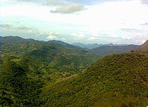
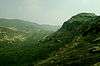
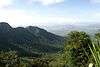
The Kalrayan Hills (Tamil : கல்வராயன் மலை) are a major range of hills situated in the Eastern Ghats of the southern Indian state of Tamil Nadu.[1] Along with the Pachaimalai, Javadi, and Shevaroy hills, they separate the Kaveri River basin to the south from the Palar River basin to the north.[2] The hills range in height from 2000 feet to 3000 feet[3] and extend over an area of 1095 square kilometres.[1]
The hills straddle a number of Tamil Nadu districts, extending northeast from the Salem District.[1] The range serves as a boundary between the Salem and Villupuram districts.[3] The Kalrayans are divided into two sections — the northern section, referred to as the Chinna ("little") Kalrayans, and the southern section, called the Periya ("big") Kalrayans. The Chinna Kalrayans average 2700 feet in height, while the Periya Kalrayans average 4000 feet.[3]
The range as a whole is fairly smooth, with soil well-suited for plant growth.[3] Scrub jungles reach up to 400 metres in altitude, while deciduous forests can be found between above 800 metres. Sholas, a type of high-altitude stunted evergreen forest, can be found growing on isolated plateaus.[1] Though the forest stand is growing, due to "habitat uniqueness, human impacts and cultural tradition," conservation efforts are needed.[4]
History
Kalvarayan hill was being ruled by the following three jagirdhars (Poligars) - Sadaya Goundan, Kurumba Goundan and Arya Goundan. Till June 25, 1976 the area was "not part of India, as there was no presence of governance or any government till then". The three jagirdhars were mini-rulers of the locality and they were not willing to recognise the government of India and abide by its statutes by handing over 105 villages under them. As per 1901 census, Sadaya Goundan had 40 villages with a population of 10,009, Kurumba Goundar had 40 villages with a population of 7,490 and Arya Goundan had 11 villages with 2,318 people. The community had wedding tax, cultivation tax, registration of births and deaths, and everyone had to offer gifts to jagirdhar's families during Pongal celebrations. The hill was brought under the government control on June 25, 1976 by invoking slavery abolition legislation, 1963.
References
- 1 2 3 4 Sakthivel, R., M. Manivel, A. Alagappa Moses (2003). "Application of Remote Sensing data for Delineation of Ground Water potential zones in the Kalrayan Hills, Tamil Nadu". GISdevelopment.net. Retrieved 2007-03-16.
- ↑ "Pachaimalai Hills". Encyclopædia Britannica. Encyclopædia Britannica Online. 2007. Retrieved 2007-03-15.
- 1 2 3 4 Nazer, M. (2004). "A Study of Land Alienation and Indebtedness among Tribals in Tamil Nadu, Kerala and Karnataka states" (PDF). Planning Commission, Government of India. Retrieved 2007-03-15.
- ↑ Kadavul, K., N. Parthasarathy (19 April 1999). "Structure and composition of woody species in tropical semi-evergreen forest of Kalrayan hills, Eastern Ghats, India". Trop. Ecol. 40 (2): 247–260. ISSN 0564-3295. Retrieved 2007-03-16.
External links
| Wikimedia Commons has media related to Kalrayan Hills. |