Pawnee City, Nebraska
| Pawnee City, Nebraska | |
|---|---|
| City | |
|
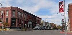
West side of G Street, looking NW from 6th St, 2010 | |
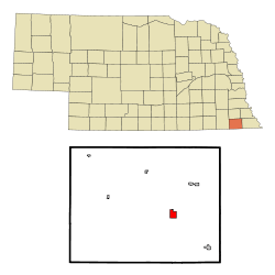 Location of Pawnee City, Nebraska | |
| Coordinates: 40°6′38″N 96°9′13″W / 40.11056°N 96.15361°WCoordinates: 40°6′38″N 96°9′13″W / 40.11056°N 96.15361°W | |
| Country | United States |
| State | Nebraska |
| County | Pawnee |
| Incorporated | 1858[1] |
| Area[2] | |
| • Total | 1.21 sq mi (3.13 km2) |
| • Land | 1.21 sq mi (3.13 km2) |
| • Water | 0 sq mi (0 km2) |
| Elevation | 1,181 ft (360 m) |
| Population (2010)[3] | |
| • Total | 878 |
| • Estimate (2012[4]) | 866 |
| • Density | 730/sq mi (280/km2) |
| Time zone | Central (CST) (UTC-6) |
| • Summer (DST) | CDT (UTC-5) |
| ZIP code | 68420 |
| Area code(s) | 402 |
| FIPS code | 31-38575 [5] |
| GNIS feature ID | 0832001 [6] |
| Website | pawneecity.com |
Pawnee City is a city and county seat of Pawnee County, Nebraska, United States.[7] The population was 878 at the 2010 census.
History
Pawnee City was incorporated in 1858,[1] and is named after the Pawnee Indian tribe.[8]
By the 1880s, Pawnee City was a railroad town at the junction of two railroad lines.[9]
Geography
Pawnee City is located at 40°6′38″N 96°9′13″W / 40.11056°N 96.15361°W (40.110603, −96.153553).[10] According to the United States Census Bureau, the city has a total area of 1.21 square miles (3.13 km2), all of it land.[2]
Demographics
| Historical population | |||
|---|---|---|---|
| Census | Pop. | %± | |
| 1880 | 763 | — | |
| 1890 | 1,550 | 103.1% | |
| 1900 | 1,969 | 27.0% | |
| 1910 | 1,610 | −18.2% | |
| 1920 | 1,595 | −0.9% | |
| 1930 | 1,573 | −1.4% | |
| 1940 | 1,647 | 4.7% | |
| 1950 | 1,606 | −2.5% | |
| 1960 | 1,343 | −16.4% | |
| 1970 | 1,267 | −5.7% | |
| 1980 | 1,156 | −8.8% | |
| 1990 | 1,008 | −12.8% | |
| 2000 | 1,033 | 2.5% | |
| 2010 | 878 | −15.0% | |
| Est. 2015 | 827 | [11] | −5.8% |
| U.S. Decennial Census | |||
2010 census
As of the census[3] of 2010, there were 878 people, 425 households, and 210 families residing in the city. The population density was 725.6 inhabitants per square mile (280.2/km2). There were 518 housing units at an average density of 428.1 per square mile (165.3/km2). The racial makeup of the city was 96.9% White, 0.2% African American, 0.3% Native American, 0.2% Asian, 0.3% from other races, and 1.9% from two or more races. Hispanic or Latino of any race were 2.1% of the population.
There were 425 households of which 19.1% had children under the age of 18 living with them, 39.3% were married couples living together, 7.5% had a female householder with no husband present, 2.6% had a male householder with no wife present, and 50.6% were non-families. 45.6% of all households were made up of individuals and 25.4% had someone living alone who was 65 years of age or older. The average household size was 1.97 and the average family size was 2.79.
The median age in the city was 52.9 years. 18.7% of residents were under the age of 18; 5.3% were between the ages of 18 and 24; 15.7% were from 25 to 44; 28.5% were from 45 to 64; and 31.8% were 65 years of age or older. The gender makeup of the city was 47.2% male and 52.8% female.
2000 census
As of the census[5] of 2000, there were 1,033 people, 474 households, and 264 families residing in the city. The population density was 881.9 people per square mile (340.9/km²). There were 542 housing units at an average density of 462.7 per square mile (178.9/km²). The racial makeup of the city was 99.13% White, 0.19% Native American, 0.10% Asian, and 0.58% from two or more races. Hispanic or Latino of any race were 0.68% of the population.
There were 474 households out of which 22.4% had children under the age of 18 living with them, 47.3% were married couples living together, 7.2% had a female householder with no husband present, and 44.3% were non-families. 42.2% of all households were made up of individuals and 27.8% had someone living alone who was 65 years of age or older. The average household size was 2.07 and the average family size was 2.79.
In the city the population was spread out with 20.7% under the age of 18, 4.3% from 18 to 24, 19.4% from 25 to 44, 20.5% from 45 to 64, and 35.1% who were 65 years of age or older. The median age was 50 years. For every 100 females there were 75.7 males. For every 100 females age 18 and over, there were 72.4 males.
As of 2000 the median income for a household in the city was $23,587, and the median income for a family was $32,717. Males had a median income of $25,489 versus $18,500 for females. The per capita income for the city was $17,386. About 8.3% of families and 14.3% of the population were below the poverty line, including 12.7% of those under age 18 and 16.0% of those age 65 or over.
Notable people
See also List of people from Pawnee County, Nebraska
- David Butler, first governor of Nebraska (1867–1871)
- Lavon Heidemann, lieutenant governor of Nebraska
- Larry the Cable Guy, comedian
- Irish McCalla, actress
- Kenneth S. Wherry, mayor, U.S. Senator from Nebraska 1943-51; Senate Republican Leader[12]
See also
References
- 1 2 "Pawnee City Nebraska". City-Data.com. Retrieved October 19, 2012.
- 1 2 "US Gazetteer files 2010". United States Census Bureau. Archived from the original on January 24, 2012. Retrieved 2012-06-24.
- 1 2 "American FactFinder". United States Census Bureau. Retrieved 2012-06-24.
- ↑ "Population Estimates". United States Census Bureau. Archived from the original on June 17, 2013. Retrieved 2013-05-29.
- 1 2 "American FactFinder". United States Census Bureau. Retrieved 2008-01-31.
- ↑ "US Board on Geographic Names". United States Geological Survey. 2007-10-25. Retrieved 2008-01-31.
- ↑ "Find a County". National Association of Counties. Archived from the original on May 31, 2011. Retrieved 2011-06-07.
- ↑ "Profile for Pawnee City, Nebraska, NE". ePodunk. Retrieved October 19, 2012.
- ↑ "Pawnee City, Pawnee County". Center for Advanced Land Management Information Technologies. University of Nebraska. Retrieved 21 August 2014.
- ↑ "US Gazetteer files: 2010, 2000, and 1990". United States Census Bureau. 2011-02-12. Retrieved 2011-04-23.
- ↑ "Annual Estimates of the Resident Population for Incorporated Places: April 1, 2010 to July 1, 2015". Retrieved July 2, 2016.
- ↑ "WHERRY, Kenneth Spicer, (1892 - 1951)". Biographical Directory of the United States Congress. Retrieved October 19, 2012.
External links
| Wikimedia Commons has media related to Pawnee City, Nebraska. |
Municipalities and communities of Pawnee County, Nebraska, United States | ||
|---|---|---|
| City | ||
| Villages | ||
| Unincorporated communities | ||
| Ghost town | ||