Ottawa County, Ohio
| Ottawa County, Ohio | |||
|---|---|---|---|
| |||
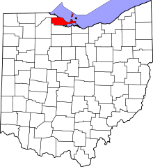 Location in the U.S. state of Ohio | |||
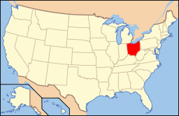 Ohio's location in the U.S. | |||
| Founded | March 6, 1840[1] | ||
| Named for | the Ottawa tribe or a word meaning "trader" | ||
| Seat | Port Clinton | ||
| Largest city | Port Clinton | ||
| Area | |||
| • Total | 585 sq mi (1,515 km2) | ||
| • Land | 255 sq mi (660 km2) | ||
| • Water | 330 sq mi (855 km2), 56% | ||
| Population | |||
| • (2010) | 41,428 | ||
| • Density | 163/sq mi (63/km²) | ||
| Congressional districts | 5th, 9th | ||
| Time zone | Eastern: UTC-5/-4 | ||
| Website |
www | ||


Ottawa County is a county located in the U.S. state of Ohio. As of the 2010 census, the population was 41,428.[2] Its county seat is Port Clinton.[3] The county is named either for the Ottawa Indians who lived there, or for an Indian word meaning "trader".[4]
Ottawa County comprises the Port Clinton, OH Micropolitan Statistical Area, which is also included in the Toledo-Port Clinton, OH Combined Statistical Area.
History
On September 10, 1813, during the War of 1812, nine vessels of the United States Navy under Commodore Oliver Hazard Perry, decisively defeated six vessels of Great Britain’s Royal Navy in the Battle of Lake Erie near Put-in-Bay. This action was one of the major battles of the war.
Ottawa County was formed on March 6, 1840 from portions of Erie, Lucas and Sandusky counties. It was named after the North American Indian tribe of the Ottawa.[5]
In 1974, the County Courthouse was listed on the National Register of Historic Places. [6]
The county is notable in presidential politics for being a bellwether, having continuously voted for the winning candidate for thirteen elections beginning in 1964. [7]
Geography
According to the U.S. Census Bureau, the county has a total area of 585 square miles (1,520 km2), of which 255 square miles (660 km2) is land and 330 square miles (850 km2) (56%) is water.[8] It is the third-smallest county in Ohio by land area. It borders Ontario across Lake Erie.
Adjacent counties
- Essex County, Ontario, Canada (northeast)
- Erie County (southeast)
- Sandusky County (south)
- Wood County (west)
- Lucas County (northwest)
National protected areas
Demographics
| Historical population | |||
|---|---|---|---|
| Census | Pop. | %± | |
| 1840 | 2,248 | — | |
| 1850 | 3,308 | 47.2% | |
| 1860 | 7,016 | 112.1% | |
| 1870 | 13,364 | 90.5% | |
| 1880 | 19,762 | 47.9% | |
| 1890 | 21,974 | 11.2% | |
| 1900 | 22,213 | 1.1% | |
| 1910 | 22,360 | 0.7% | |
| 1920 | 22,193 | −0.7% | |
| 1930 | 24,109 | 8.6% | |
| 1940 | 24,360 | 1.0% | |
| 1950 | 29,469 | 21.0% | |
| 1960 | 35,323 | 19.9% | |
| 1970 | 37,099 | 5.0% | |
| 1980 | 40,076 | 8.0% | |
| 1990 | 40,029 | −0.1% | |
| 2000 | 40,985 | 2.4% | |
| 2010 | 41,428 | 1.1% | |
| Est. 2015 | 40,877 | [9] | −1.3% |
| U.S. Decennial Census[10] 1790-1960[11] 1900-1990[12] 1990-2000[13] 2010-2013[2] | |||
2000 census
As of the census[14] of 2000, there were 40,985 people, 16,474 households, and 11,729 families residing in the county. The population density was 161 people per square mile (62/km²). There were 25,532 housing units at an average density of 100 per square mile (39/km²). The racial makeup of the county was 96.56% White, 0.65% Black or African American, 0.21% Native American, 0.23% Asian, 0.05% Pacific Islander, 1.44% from other races, and 0.87% from two or more races. 3.75% of the population were Hispanic or Latino of any race.
There were 16,474 households out of which 29.10% had children under the age of 18 living with them, 58.90% were married couples living together, 8.50% had a female householder with no husband present, and 28.80% were non-families. 25.00% of all households were made up of individuals and 11.20% had someone living alone who was 65 years of age or older. The average household size was 2.45 and the average family size was 2.92.
In the county, the population was spread out with 23.30% under the age of 18, 6.70% from 18 to 24, 26.80% from 25 to 44, 26.80% from 45 to 64, and 16.40% who were 65 years of age or older. The median age was 41 years. For every 100 females there were 97.50 males. For every 100 females age 18 and over, there were 94.70 males.
The median income for a household in the county was $44,224, and the median income for a family was $51,919. Males had a median income of $39,823 versus $24,727 for females. The per capita income for the county was $21,973. About 4.20% of families and 5.90% of the population were below the poverty line, including 7.40% of those under age 18 and 5.40% of those age 65 or over.
2010 census
As of the 2010 United States Census, there were 41,428 people, 17,503 households, and 11,884 families residing in the county.[15] The population density was 162.5 inhabitants per square mile (62.7/km2). There were 27,909 housing units at an average density of 109.5 per square mile (42.3/km2).[16] The racial makeup of the county was 96.5% white, 0.8% black or African American, 0.3% Asian, 0.2% American Indian, 0.9% from other races, and 1.3% from two or more races. Those of Hispanic or Latino origin made up 4.2% of the population.[15] In terms of ancestry, 44.6% were German, 11.9% were Irish, 9.8% were English, 6.3% were American, and 6.1% were Polish.[17]
Of the 17,503 households, 26.3% had children under the age of 18 living with them, 54.7% were married couples living together, 8.9% had a female householder with no husband present, 32.1% were non-families, and 27.4% of all households were made up of individuals. The average household size was 2.34 and the average family size was 2.82. The median age was 46.3 years.[15]
The median income for a household in the county was $53,463 and the median income for a family was $64,258. Males had a median income of $52,736 versus $33,557 for females. The per capita income for the county was $27,809. About 6.3% of families and 9.0% of the population were below the poverty line, including 11.9% of those under age 18 and 6.5% of those age 65 or over.[18]
Politics
| Year | Republican | Democrat |
|---|---|---|
| 2016 | 56.47% 12,389 | 37.08% 8,136 |
| 2012 | 46.83% 10,538 | 51.11% 11,503 |
| 2008 | 46.01% 10,624 | 52.25% 12,064 |
| 2004 | 51.91% 12,073 | 47.80% 11,118 |
| 2000 | 49.66% 9,917 | 47.50% 9,485 |
Government and politics
County officials
The County elects 9 holders.
| Office | Name | Party |
|---|---|---|
| Commissioner | James M. Sass | Democrat |
| Commissioner | Mark W. Stahl | Republican |
| Commissioner | Jo Ellen Regal | Democrat |
| Prosecutor | Mark Mulligan | Democrat |
| Sheriff | Stephen J. Levorchick | Democrat |
| Clerk of Courts | Gary Kohli | Democrat |
| Recorder | Virginia M. Park | Democrat |
| Treasurer | Robert Hille | Democrat |
| Engineer | Ronald Lajti | Democrat |
| Coroner | Daniel Cadigan | Democrat |
| Auditor | Larry Hartlaub | Democrat |
| Common Pleas Court Judge | Bruce A. Winters | |
| Juvenile Court Judge | Kathleen L. Giesler | |
| Municipal Court Judge | Frederick C. Hany, II |
Transportation
Major highways
10 major highways run through Ottawa County, including two interstates, and eight state routes.
Airports
- Erie-Ottawa Regional Airport
- Middle Bass-East Point Airport
- Middle Bass Island Airport
- North Bass Island Airport
- Put-in-Bay Airport
Communities
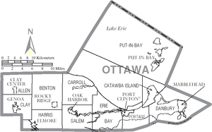
City
- Port Clinton (county seat)
Villages
Townships
Unincorporated communities
- Blackberry Corner
- Camp Perry
- Catawba Island
- Curtice
- Danbury
- Elliston[21]
- Forest Park
- Graytown
- Grodis Corner
- Gypsum
- Hickory Grove
- Isle St. George
- Lacarne
- Lakeside
- Lakeside Marblehead
- Limestone
- Locust Point
- Martin
- Middle Bass
- Trowbridge
- Williston
- Yale
Notable residents
- Crystal Bowersox - singer-songwriter, 2010 American Idol runner-up, from Elliston
- Louis C. Shepard - American Civil War Medal of Honor recipient from Ashtabula County, buried in Lakeview cemetery, Port Clinton, Ohio.
See also
References
- ↑ "Ohio County Profiles: Ottawa County" (PDF). Ohio Department of Development. Retrieved 2007-04-28.
- 1 2 "State & County QuickFacts". United States Census Bureau. Retrieved February 9, 2015.
- ↑ "Find a County". National Association of Counties. Retrieved 2011-06-07.
- ↑ "Ottawa County data". Ohio State University Extension Data Center. Retrieved 2007-04-28.
- ↑ "Ottawa County". www.co.ottawa.oh.us. Retrieved 2016-03-15.
- ↑ "AssetDetail". focus.nps.gov. Retrieved 2016-03-15.
- ↑ "The Ohio county that picks presidents is leaning Trump". BBC. 2016-07-23. Retrieved 2016-07-23.
- ↑ "2010 Census Gazetteer Files". United States Census Bureau. August 22, 2012. Retrieved February 9, 2015.
- ↑ "County Totals Dataset: Population, Population Change and Estimated Components of Population Change: April 1, 2010 to July 1, 2015". Retrieved July 2, 2016.
- ↑ "U.S. Decennial Census". United States Census Bureau. Retrieved February 9, 2015.
- ↑ "Historical Census Browser". University of Virginia Library. Retrieved February 9, 2015.
- ↑ Forstall, Richard L., ed. (March 27, 1995). "Population of Counties by Decennial Census: 1900 to 1990". United States Census Bureau. Retrieved February 9, 2015.
- ↑ "Census 2000 PHC-T-4. Ranking Tables for Counties: 1990 and 2000" (PDF). United States Census Bureau. April 2, 2001. Retrieved February 9, 2015.
- ↑ "American FactFinder". United States Census Bureau. Retrieved 2008-01-31.
- 1 2 3 "DP-1 Profile of General Population and Housing Characteristics: 2010 Demographic Profile Data". United States Census Bureau. Retrieved 2015-12-27.
- ↑ "Population, Housing Units, Area, and Density: 2010 - County". United States Census Bureau. Retrieved 2015-12-27.
- ↑ "DP02 SELECTED SOCIAL CHARACTERISTICS IN THE UNITED STATES – 2006-2010 American Community Survey 5-Year Estimates". United States Census Bureau. Retrieved 2015-12-27.
- ↑ "DP03 SELECTED ECONOMIC CHARACTERISTICS – 2006-2010 American Community Survey 5-Year Estimates". United States Census Bureau. Retrieved 2015-12-27.
- ↑ "Dave Leip's Atlas of U.S. Presidential Elections". Retrieved 2016-03-26.
- ↑ Ottawa County Elected Officials
- ↑ "Trinity United Church of Christ (Elliston, Ohio)". Bowling Green State University. Retrieved 2010-03-09.
External links
 |
Lucas County | Lake Erie | | |
| Wood County | |
|||
| ||||
| | ||||
| Sandusky County | Erie County |
Municipalities and communities of Ottawa County, Ohio, United States | ||
|---|---|---|
| City | | |
| Villages | ||
| Townships | ||
| CDPs | ||
| Unincorporated communities | ||
| Footnotes | ‡This populated place also has portions in an adjacent county or counties | |
Coordinates: 41°35′N 83°04′W / 41.59°N 83.06°W