Woluwe-Saint-Pierre
| Woluwe-Saint-Pierre Woluwe-Saint-Pierre (French) Sint-Pieters-Woluwe (Dutch) | |||
|---|---|---|---|
| Municipality | |||
|
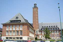
Woluwe Saint-Pierre’s town hall | |||
| |||
 Woluwe-Saint-Pierre Location in Belgium | |||
|
Woluwe-Saint-Pierre municipality in the Brussels-Capital Region  | |||
| Coordinates: 50°50′N 04°28′E / 50.833°N 4.467°ECoordinates: 50°50′N 04°28′E / 50.833°N 4.467°E | |||
| Country | Belgium | ||
| Community |
Flemish Community French Community | ||
| Region | Brussels | ||
| Arrondissement | Brussels | ||
| Government | |||
| • Mayor | Willem Draps (MR) | ||
| Area | |||
| • Total | 8.85 km2 (3.42 sq mi) | ||
| Population (1 January 2016)[1] | |||
| • Total | 41,207 | ||
| • Density | 4,700/km2 (12,000/sq mi) | ||
| Postal codes | 1150 | ||
| Area codes | 02 | ||
| Website | www.woluwe1150.be | ||

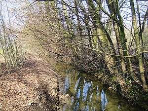
Woluwe-Saint-Pierre (French pronunciation: [wolywe sɛ̃ pjɛːʁ][2]) or Sint-Pieters-Woluwe (Dutch, pronounced [sɪnt ˈpitərs ˈʋoːlyʋə]) is one of the nineteen municipalities located in the Brussels-Capital Region of Belgium. It is mostly a well-to-do residential area, which includes the wide, park-lined, Avenue de Tervueren and the numerous embassies located near the Montgomery Square. Of the three rivers that once crossed the municipality, only the Woluwe, a tributary of the Senne, can still largely be seen today.
History
Middle Ages to Albert and Isabella
The first appearance of the name Wolewe dates from 1117 and can be found in a charter from Forest (Vorst in Dutch). At that time, the original hamlet and its farms were dependencies of the abbey of Park near Leuven. The onset of difficulties can be traced to the middle of the 16th century, with the hostilities waged by Philip II of Spain against the heretical Protestants and the ensuing poverty and famine took their toll on the entire population. Safety and prosperity returned under the reigns of Archdukes Albert and Isabella at the beginning of the 17th century. The first highway linking Tervuren to Brussels, then known as the “Street of the Duke”, dates from that period.
18th century until now
The French Revolution was also a troubled period for Woluwe-Saint-Pierre – Sint-Pieters-Woluwe. The roads became insecure; the religious freedoms were drastically curtailed; much of the local wild life was exterminated for food; and the lack of coal and wood forced people to use peat for heating. The local administration gained its independence from Brussels, obtained its first mayor on May 26 and its first municipal council in 1819. The commercial opportunities that opened up to the new commune marked the start of a new era of wealth. The city did not expand very fast, however, until the last two decades of the 19th century. New roads, such as the Tervuren Avenue, a new train track, imposing mansions, such as the “Stoclet Palace”, and the Woluwe Park were all built or designed between 1880 and 1910. An important race track, now demolished, was built in 1906. The residential areas came into being right after the First World War and further urbanization took place after the Second World War. Today, agriculture and fisheries, common before 1918, have completely disappeared. The area lives nearly exclusively off the service sector of the economy.
Sights
- The extensive Woluwe Park includes giant sequoias, cypresses, and a variety of birds such as swans, gulls, and herons.
- The imposing modern city hall is open to visitors.
- The town’s main church (Saint Peter) was erected in 1755 on the site of a much older building and perpendicular to it, with funds from the abbey of Forest. Traces of the older building can still be seen on the left of the current church.
- Several turn-of-the-century houses and manors can still be seen today, such as the Stoclet Palace, which was built between 1905 and 1909 on a design by Josef Hoffmann and contains mosaics and paintings by Gustav Klimt.
- The Bibliotheca Wittockiana houses one of the most prestigious bookbinding collections in the world.
- The memorial on Avenue Jules Cesar to the Belgian United Nations Command, the force sent by Belgium to aid South Korea during the Korean War (1950-1953).
- The Brussels Tram Museum displays a collection of trams and buses of different ages
Famous inhabitants
- Henri d'Orléans, Count of Paris, pretender to the French throne (b. 1933)
- Eddy Merckx (not currently residing), professional cyclist, multiple winner of the Tour de France and Giro d'Italia in the 1960s and 1970s.
- Jean Bingen (1920–2012), papyrologist and epigrapher died in the city
Twin Cities
-
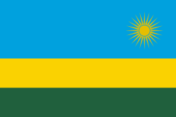 Rwanda: Ruyumba, Gitarama Province
 -
 South Korea: Gangnam-gu (Seoul)
 -
 United States: New Iberia, Louisiana
 -
 Romania: Pecica
 -
 China: Chaoyang
 -
 India: Chennai
See also
- Woluwe River
- Woluwe-Saint-Lambert / Sint-Lambrechts-Woluwe, an adjacent municipality
- Sint-Stevens-Woluwe
References
- ↑ Population per municipality as of 1 January 2016 (XLS; 397 KB)
- ↑ Woluwe-Saint-Pierre is sometimes also spelled in French: Woluwé-Saint-Pierre with an accent on the first "e". Though the first version (without an accent) is the official version, the second one fits more the French pronunciation.
- Falkenback, Pierre (1973). Historique de Woluwe-Saint-Pierre (in French). Brussels: Commune de Woluwe-Saint-Pierre. OCLC 1419423.
- Culot, P. (1996). Bibliotheca Wittockiana. Brussels:Crédit communal, ISBN 90-5544-103-1.
External links
| Wikimedia Commons has media related to Woluwe-Saint-Pierre. |
- Official site of the municipality, in French, Dutch, and English
- Official website of the Bibliotheca Wittockiana
 |
Woluwe-Saint-Lambert | | ||
| Etterbeek | |
Kraainem (VBR) | ||
| ||||
| | ||||
| Auderghem | Tervuren (VBR) |
Brussels topics | ||||||||||||||||||||
|---|---|---|---|---|---|---|---|---|---|---|---|---|---|---|---|---|---|---|---|---|
| ||||||||||||||||||||
Portal | ||||||||||||||||||||