Srikakulam district
| Srikakulam district శ్రీకాకుళం జిల్లా | |
|---|---|
| District of Andhra Pradesh | |
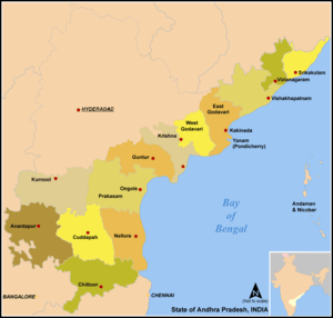
 Location of Srikakulam district in Andhra Pradesh | |
| Country | India |
| State | Andhra Pradesh |
| Headquarters | Srikakulam |
| Tehsils | 37[1] |
| Government | |
| • Lok Sabha constituencies | Srikakulam (Lok Sabha constituency) |
| • Assembly seats | 10 |
| Area | |
| • Total | 5,837 km2 (2,254 sq mi) |
| Population (2011) | |
| • Total | 2,699,471[2] |
| • Urban | 16.16% |
| Demographics | |
| • Literacy | 62.30% |
| • Sex ratio | 1014 |
| Vehicle registration | AP-10 |
| Major highways | NH-5 |
| Coordinates | 18°25′N 84°01′E / 18.417°N 84.017°ECoordinates: 18°25′N 84°01′E / 18.417°N 84.017°E |
| Website | [Srikakulam district website Official website] |
Srikakulam district is one of the 13 districts in the Indian state of Andhra Pradesh. It is one of the 9 coastal districts, located in the extreme north eastern direction of the state. The headquarters of the district is located at Srikakulam.[1] It was formerly known as Chicacole.
Geography
It is situated within the geographic co-ordinates of 18°-20’ and 19°-10’ N and 83°-50’ and 84°-50’ E. The district is skirted to a distance by Kandivalasagedda, Vamsadhara and Bahuda at certain stretches of their courses while a line of heights of the great Eastern Ghats run from the northeast. Vizianagaram district flanks in the south and west while Odisha bounds it on the north and Bay of Bengal on the East.
History
Prehistory
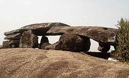
Evidence of early historic man and his activities during Stone Age and Iron Age periods have been recently discovered at Sangamayya Konda and Dannanapeta. The speciality of Dannanapeta Iron Age megalithic site is a large single capstone as a dolmen with 36 ft in length and 14 ft in width and 2 ft thickness. Sailada Hills consists of 36 upright rocks and natural caves used for habitation by Iron Age man in Amudalavalasa mandal of the district.[3]
Jainism and Buddhism
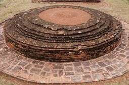
Evidences of Jain monuments and Buddhist remnants were discovered near Sangamayya Konda. Jain rock beds were discovered at Dannanapeta near Amudalavalasa in the district. Salihundam is a famous Buddhist Remnants site situated on the south bank of River Vamsadhara at a distance of 5 kilometres west of Kalingapatnam and 18 kilometres from Srikakulam town.[4]
Post Independence
Srikakulam District was carved out in 1950 by bifurcating it from Visakhapatnam District, it remained unaffected in its territorial jurisdiction for quite some time. But in November 1969 the district lost 63 Villages from Saluru Taluk and 44 Villages from Bobbili Taluk on account of their transfer to the then newly constituted Gajapathinagaram Taluk of Visakhapatnam District. Again in May 1979, the district had undergone major territorial changes on account of the formation of new District with headquarters at Vizianagaram which involved transfer of Salur, Bobbili, Parvathipuram and Cheepurupalli Taluks to the new District.Srikakulam's culture is a blend of traditional festivals, food, music and theatres.[5]
Geography
Srikakulam district occupies an area of 5,837 square kilometres (2,254 sq mi),[6] comparatively equivalent to Australia's Melville Island.[7] Srikakulam district can be divided into two main distinct natural divisions. A portion of Srikakulam district is plain terrain with intense agriculture and another portion of the district is rocky and hilly terrain covered with forests. Some of the Mahendragiri Hills also covers Srikakulam district. Most of the forest area of the plain terrain has been damaged by intense agriculture. Kotthuru, Hiramandalam, Pathapatnam, Kalingadal reservoir and some other areas are still covered with dense forests.
Srikakulam is located 100 km (62 mi) north of Visakhapatnam. It has a population of 2,537,593 of which 10.98% is urban as of 2001.
Srikakulam district has the longest coast line about 193 km (120 mi) in the state of Andhra Pradesh. It is bordered by Odisha on the north, Vizianagaram district on the west and south, Bay of Bengal on the east.
Major Rivers flowing through the district are River Nagavali, River Vamsadhara, Mahendratanaya, Champavati, Bahuda, Kumbhikota Gedda, Suvarnamukhi, Vegavati, Gomukhi. The Nagavali and Vamsadhara are the major rivers in Srikakulam district. These two river basins together constitute about 5% of the area. The Mahendratanaya and Bahuda rivers are two minor river basins in the district. Others are Benjigedda, Peddagedda, Kandivalasa gedda. Major irrigation projects on these rivers Vamsadhara Project, Narayanapuram Anicut, Thotapalli Regulator and some medium projects at Pydigam Project, Onigadda are providing a total ayacut of 69,373 acres (280.74 km2).
Demographics
147 According to the 2011 census Srikakulam district has a population of 2,699,471,[8] roughly equal to the nation of Kuwait[9] or the US state of Nevada. This gives it a ranking of 147th in India (out of a total of 640).[8] The district has a population density of 462 inhabitants per square kilometre (1,200/sq mi) .[8] Its population growth rate over the decade 2001-2011 was 6.38%.[8] Srikakulam has a sex ratio of 1014 females for every 1000 males,[8] and a literacy rate of 62.3%.[8]
Household indicators
According to 2007–08, International Institute for Population Sciences,[10] 86.9% had access to electricity, 70.4% had drinking water, 18.5% toilet facilities, and 47.2% lived in a pucca (permanent) home.[10] 31.5% of girls wed before the legal age of 18 and 90.1% of interviewees carried a BPL card.[10]
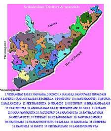
Divisions
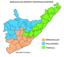
The district has three revenue divisions namely, Srikakulam, Palakonda and Tekkali, each headed by a sub collector. These revenue divisions are divided into 38 mandals in the district.[11] The district has 12 towns and 1,802 villages. There are 1 municipal corporation, 3 municipalities, 1 nagar panchayat and 7 census towns. The municipal corporation in the district is Srikakulam and 3 municipalities in the district are Amadalavalasa, Ichchapuram, Palasa-Kasibugga, and nagar panchayats of Palakonda, Rajam.[12] The 6 census towns are Balaga, Hiramandalam, Narasannapeta, Ponduru, Sompeta, Tekkali.[13]
Mandals
The list of 38 mandals in Srikakulam district under 3 revenue divisions are listed in the following table:
Parliamentary and Assembly constituencies
There are 3 Parliamentary Constituencies and 10 assembly constituencies in Srikakulam district. Parliamentary constituencies include Srikakulam, Araku, Vizianagaram ,[14]
The 10 Assembly Constituencies are Amadalavalasa, Rajam, Tekkali, Ichchapuram, Palasa, Narasannapeta, Palakonda, Pathapatnam, Srikakulam and Etcherla.
Economy

Major pharmaceutical company namely Dr. Reddy's Laboratories is situated at Pydibhimavaram. Cashew industries located in Palasa. It is famous in South India
Transport
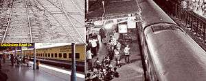
APSRTC runs bus services to all the major cities and towns of the state from the district. Major railway stations in the district include Amudalavalasa, Srikakulam Road railway station, Palasa (It is major railwaystation) Naupada, Ichchapuram and Sompeta etc. The Nearest Airport is Visakhapatnam which is 100 km away from the city.
Culture
The district is renowned for the brassware products namely, Budithi Bell and Brass Craft, which are made at Budithi village of the district. These are registered as one of the geographic indication from Andhra Pradesh.[15]
The district has many people from various fields like film industry, music, art and architecture etc. Most notable of them are Vaddadi Papaiah, J.V. Somayajulu, G.Anand (playback singer & music director), Pingali Nagendrarao (script writer and lyricist), Sripada Pinakapani (carnatic musician). Some of the poets and writers include Gidugu Venkata Ramamoorty, Pingali Nagendrarao, Kalipatnam Ramarao etc. There are many freedom fighters from the district like Gouthu Latchanna, Killi Appala Naidu (freedom fighter), Jananayak Chowdary Satyanarayana, Garimella Satyanarayana etc.
Sports
Kodi Rammurthy Naidu (body builder), Karnam Malleswari (Olympic medalist),[10] Pujari Sailaja in weight lifting are famous people from the district.
Tourism

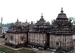
The district has many religious worship centres like Arasavalli temple of sun god, Srikurmam temple of Vishnu-Kurmavtar, Mukhalingam temple of Shiva, Salihundam, Dantapuri which are Buddhist remnant sites. Apart from these there other tourist destinations like Telineelapuram Bird sanctuary. Many sun kissed beaches like Baruva, Bhavanapadu, Kalingapatnam, Mogadalapadu and Kallepalli.
Transport
The total of core road network of the district is 958.791 km (595.765 mi). It includes, 602.811 km (374.569 mi) of existing and a proposed length of 355.980 km (221.196 mi).[16]
Education
The primary and secondary school education is imparted by government, aided and private schools, under the School Education Department of the state.[17][18] As per the school information report for the academic year 2015-16, there are a total of 3,875 schools. They include, 55 government, 2,833 mandal and zilla parishads, 1 residential, 573 private, 14 model, 32 Kasturba Gandhi Balika Vidyalaya (KGBV), 85 municipal and 282 other types of schools.[19] The total number of students enrolled in primary, upper primary and high schools of the district are 371,472.[20]
The only university in the district include Dr. B. R. Ambedkar University, Srikakulam[21] and medical colleges namely Rajiv Gandhi Institute of Medical Sciences in Srikakulam town, GEMS—Great Eastern Medical Speciality and Hospital in Ragolu village.
See also
References
- 1 2 "District - Krishna". Andhra Pradesh Online Portal. Retrieved 23 August 2014.
- ↑ "Srikakulam district profile". Andhra Pradesh State Portal.
- ↑ "Iron Age habitation found in Srikakulam". The Hindu. 16 October 2011. Retrieved 14 June 2014.
- ↑ "Remnants of Jain monuments found". 21 August 2009. Retrieved 14 June 2014.
- ↑ Law, Gwillim (25 September 2011). "Districts of India". Statoids. Retrieved 11 October 2011.
- ↑ Srivastava, Dayawanti et al. (ed.) (2010). "States and Union Territories: Andhra Pradesh: Government". India 2010: A Reference Annual (54th ed.). New Delhi, India: Additional Director General, Publications Division, Ministry of Information and Broadcasting (India), Government of India. pp. 1111–1112. ISBN 978-81-230-1617-7.
- ↑ "Island Directory Tables: Islands by Land Area". United Nations Environment Program. 18 February 1998. Retrieved 11 October 2011.
Melville Island 5,765km2
- 1 2 3 4 5 6 "District Census 2011". Census2011.co.in. 2011. Retrieved 30 September 2011.
- ↑ US Directorate of Intelligence. "Country Comparison:Population". Retrieved 1 October 2011.
Kuwait 2,595,62
- 1 2 3 "District Level Household and Facility Survey (DLHS-3), 2007-08: India. Andhra Pradesh" (PDF). International Institute for Population Sciences and Ministry of Health and Family Welfare. 2010. Retrieved 3 October 2011.
- ↑ "District - Srikakulam". Government of Andhra Pradesh. Retrieved 13 June 2015.
- ↑ "Nagar panchayat chief in ACB net - The Times of India". The Times of India. Retrieved 21 December 2015.
- ↑ "District Census Handbook - Krishna" (PDF). Census of India. pp. 26–28, 54. Retrieved 18 January 2015.
- ↑ "District-wise Assembly-Constituencies:". ceoandhra.nic.in.
- ↑ "State Wise Registration Details of G.I Applications" (PDF). Geographical Indication Registry. p. 3. Retrieved 4 February 2016.
- ↑ ":: APRDC ::". Andhra Pradesh Road Development Corporation. Roads and Buildings Department. Retrieved 9 November 2016.
- ↑ "School Education Department" (PDF). School Education Department, Government of Andhra Pradesh. Retrieved 7 November 2016.
- ↑ "The Department of School Education - Official AP State Government Portal". www.ap.gov.in. Retrieved 7 November 2016.
- ↑ "School Information Report". Commissionerate of School Education. Government of Andhra Pradesh. Retrieved 8 November 2016.
- ↑ "Student Information Report". Commissionerate of School Education. Child info 2015-16, District School Education - Andhra Pradesh. Retrieved 8 November 2016.
- ↑ "Welcome :: Dr.B.R.Ambedkar University, Srikakulam, AP. INDIA". brau.in.
External links
| Wikimedia Commons has media related to Srikakulam district. |
 |
Rayagada district, Odisha | Gajapati district, Odisha | Ganjam district, Odisha | |
| |
||||
| ||||
| | ||||
| Vizianagaram district | Bay of Bengal |
| Topics | 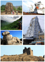 | |
|---|---|---|
| Regions | ||
| Districts | ||
| Million-plus cities | ||
| Cities (population over 1 lakh) | ||
| Tourism |
| |
| Related lists |
| |
| ||