Nandurbar district
| Nandurbar district नंदुरबार जिल्हा | |
|---|---|
| district | |
|
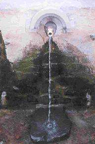
Unapdev – Hot Water Spring in Shahada | |
 Map of Maharashtra with Nandurbar highlighted in blue | |
| Coordinates: 21°13′41″N 74°08′32″E / 21.228°N 74.1422°ECoordinates: 21°13′41″N 74°08′32″E / 21.228°N 74.1422°E | |
| Country |
|
| State | Maharashtra |
| Headquarters | Nandurbar |
| Talukas | 6.Dhadgaon |
| Area | |
| • Total | 5,035 km2 (1,944 sq mi) |
| Population (2011) | |
| • Total | 1,309,135 |
| • Density | 260/km2 (700/sq mi) |
| Languages | |
| • Official | Marathi |
| Time zone | IST (UTC+5:30) |
| Telephone code | 91-2564 |
| ISO 3166 code | IN-MH-NB |
| Vehicle registration | MH-39[1] |
| Sex ratio | 975 ♂/♀ |
| Literacy | 64.38%% |
| Website |
nandurbar |
Nandurbar is an administrative district in the northwest corner (Khandesh Region) of Maharashtra state in India . On 1 July 1998 Dhule was bifurcated as two separate districts now known as Dhule and Nandurbar. The district headquarters are located at Nandurbar city. The district occupies an area of 5035 km² and has a population of 1,311,709 of which 15.45% were urban (as of 2001).[2]
Nandurbar district is bounded to the south and south-east by Dhule district, to the west and north is the state of Gujarat, to the north and north-east is the state of Madhya Pradesh. The northern boundary of the district is defined by the great Narmada river.
Ranjana Sonawane of TembhlI village and rushil in Nandurbar district became first citizen of India to get twelve (12) digit Unique Identification on 29 September 2010. The unique identification or Aadhaar is ambitious project of the central government of India to provide unique identification to its billion plus citizens.[3]
Divisions
The district comprises 6 talukas. These talukas are Akkalkuwa, Akrani Mahal (also called Dhadgaon), Taloda, Shahada, Nandurbar and Navapur.
There is one Lok Sabha constituency in the district which is Nandurbar (ST) reserved for ST. There are four Maharashtra Assembly seats namely Akkalkuwa (ST), Shahada (ST), Nandurbar (ST), Nawapur (ST).
Sakri (ST) and Shirpur (ST) assembly seats from Dhule district are also part of Nandurbar Lok Sabha seat. Nandurbar is primarily a tribal (Adiwasi) district.
History
Before 1 July 1998 Nandurbar was part of the larger Dhule district. Nandurbar, Dhule and Jalgaon districts formed what was known as the Khandesh district. Dhule was known as the west Khandesh whereas Jalgaon was known as the east Khandesh. So, much of history applicabe to Khandesh and Dhule, is applicable to Nandurbar. Nandurbar is also known as Nandanagri as the king Named Nandaraja was the ruler of this territory. The ancient name of this region was Rasika. It is bounded on the east by Berar (ancient Vidarbha), on the north by the Nemad district (ancient Anupa) and on the south by the Aurangabad (ancient Mulaka) and Bhir (ancient Asmaka) districts. Later the country came to be called as Seunadesa after king, Seunchandra of the Early Yadava dynasty, who ruled over it. Subsequently, its name was changed to Khandesh to suit the title Khan given to the Faruqi kings by Ahmad I of Gujarat.
During Aryan's penetration of the Deccan, Agastya was the first Aryan who crossed Vindhya and resided on the bank of river Godavari. This territory became part of the Mauryan Empire during Chandragupta's southern conquest of India. Pushyamitra, the founder of Shunga dynasty overthrew Maurya dynasty and thus ruled this region. Later on the Satavahanas ruled over this region.
About 250, the Satavahans were supplanted by the Abhiras in Western Maharashtra (Regan Isvarsena). The names of feudatories of Abhiras who ruled in Khandesh have come to light from copperplates discovered at Kalachala (Gujarat) and Cave X5II at Ajanta. After the downfall of the Satavahans the Vakatakas rose to power in Vidarbha. The Vakatakas were overthrown by the Rashtrakuta family. This region was then ruled by the Chalukyas of Badami and subsequently by the Yadavas.
In 1296, Ala-ud-din Khilji invaded Ramachandra Yadava who had to pay a heavy ransom for the defeat. Ramachandra's successor Singhana III challenged the supremacy of Khilji, who sent Malik Kafur to recapture Devagiri in 1310. Singhana III was killed in the ensuing battle and Khilji's army occupied Devagiri. In 1318 the last Rajah of Devagiri Harpal was flayed alive thus comprehensively ending the Yadava rule of Devagiri. In 1345, Devagiri was passed into the hands of Hasan Gangu, the founder of Bahamani dynasty.
However, Khandesh formed the southern boundary of the Tughluq empire. In 1370, Firuz Shah Tughlaq assigned the district of Thalner and Karavanda to Malik Raja Faruqi, the founder of Faruqi dynasty. His family claimed descent from the Caliph Umar-al-Faruq. He established himself at Thalner. The Governor of Gujarat honored Malik Raja with the title Sipahsalar of Khandesh. From the title Khan the region came to be known as Khandesh: the country of the Khan.
By 1382, he became a completely independent ruler of Khandesh. At the time of his accession, Khandesh was a backward region populated by a few thousand Bhils and Kolis. The sole prosperous area in Khandesh was Asirgarh, populated by the rich cowherds, Ahirs. One of the first acts of Malik Raja was taking steps to develop the agriculture in his kingdom.
During his rule he was able to increase his area of control to such an extent that even the Gond Raja of Mandla was forced to pay tribute to him. Soon after his accession as an independent ruler, he attacked Gujarat and annexed Sultanpur and Nandurbar. Almost immediately, the governor of Gujarat Zafar Khan (Muzaffar Shah) retaliated and laid siege to Thalner. Malik Raja had to return all the territories annexed by him. He died on 19 April (April 28, according to Ferishta), 1399 and was buried in Thalner
Nasir Khan or Malik Nasir (also known as Garib Khan) was the elder son of Malik Raja, who succeeded him in 1399. He commenced his rule from Laling, as Thalner was under the control of his younger brother Malik Iftikar Hasan. Soon after his accession in 1400, he captured the fort of Asirgarh and killed its Ahir ruler, Asa Ahir. It became his capital till he shifted to Burhanpur, the new city founded by him. In 1417, with the help of Malwa sultan Hoshang Shah, he captured the fort of Thalner and imprisoned his brother Malik Iftikar (who was later granted asylum in Gujarat). Next, the combined forces of Khandesh and Malwa attacked Gujarat and occupied the Sultanpur fort. But soon, Gujarat sultan Ahmad Shah’s general Malik Turk repulsed the attack and Thalner was besieged. After swearing fealty to the Gujarat sultan, the siege was ended and Ahmad Shah honoured Malik Nasir with the title of Khan.
In 1429, Nasir Khan married off his daughter to the Bahamani prince Ala-ud-Din (Ala-ud-Din Ahmad Shah II), son of Ahmad Shah I. In the same year, Raja Kanha of Jhalawar fled from Gujarat and took refuge in Asirgarh. Later on his advice, Raja Kanha went to Bidar to ask help from the Bahamani sultan Ahmad Shah I. After initial advances in Nandurbar by the Raja along with the legions of Khandesh and Bahamani army, the Gujarat army defeated the combined forces.
In 1435, Nasir Khan supported by the Raja of Gondwana and some discontented Bahamani officials attacked and captured Berar. The Bahmani governor fled to Narnala. In retaliation, the Bahamani sultan Ala-ud-Din Ahmad Shah II’s army led by his general Malik-ut-Tujjar, first defeated him in Rohankhedaghat, then followed him to Burhanpur, ransacked the city and finally crushed his army in Laling. Nasir Khan died within a few days after this humiliating defeat on 18 September (September 19, according to Ferishta), 1437. He was also buried in Thalner.
Thus, from the period 1382 to 1601 Khandesh was successfully ruled by the Faruqi dynasty. The last ruler of the Faruqi dynasty was Bahadur Shah. On 10 December 1600 Bahadur Shah surrendered to Akbar but the fort was still held by his general Yakut Khan. Asirgarh fell to the Mughals only on 17 January 1601. Khandesh was annexed to the Mughal empire. Prince Daniyal was appointed viceroy of the Subah. Bahadur Shah was taken prisoner and he died later in Agra in 1624. Khandesh was fancifully named by Akbar as Dandes after his son Daniyal.
After the Mughal Empire's decline, the Marathas took control of Khandesh and subsequently on 3 June 1818 the Maratha Peshwa surrendered Khandesh to the British rule.
Nandurbar had its own share in the Indian struggle for independence. It was here that during the Quit India Movement of 1942 Shirishkumar Mehta, a mere boy of 15 years, lost his life by a gunshot. A small memorial has been erected in memory of Shirish Kumar in the square where he shed his blood.[4]
Demographics
As of 2001 India census,[5] Nandurbar District had a population of 1,309,135, being 50.62% male and 49.38% female. Nandurbar District has an average literacy rate of 46.63%: male literacy is 55.11%, and female literacy is 37.93%.
Languages
Languages spoken include Ahirani, a Kandeshi tongue with approximately 780 000 speakers, similar to Marathi and Bhili.;[6] and Bareli Pauri, a Bhil language with approximately 175 000 speakers, written in the Devanagari script.[7]
Others are: Marathi, Hindi, Bhili, Gujar/Gujrathi and Kokani. Ahirani is sub language of marathi 
Transport and Communication
- Total railway Lines length :90 km
- No of villages connected by road
- 12 Months :671
- Temporary :262
- Total length of the roads :4338 km
- Total length of National Highway :44 km
- Total length of State
Education
- Nandurbar District has 1354 primary schools with 4497 teachers teaching 1,59,502 students; that comes to 36 students per teacher.
- Around 257 secondary schools with 2765 teachers teaching 1,31,554 students, and no of students per teacher comes to 48.
- Total colleges for higher studies, including medical and engineering, is 30, and more than 8580 students enroll each year.
- Nandurbar District also has 6 Government ITI (Industrial Training Institutes) and 2 private ITI having 1444 students in total.
- 3 VJNT Pri. School [Mhasawad, Akrale & Nandrakhe] 2 high schools, 1 junior college
- 1 SC Residential School Shahada
Economy
In 2006 the Ministry of Panchayati Raj named Nandurbar one of the country's 250 most backward districts (out of a total of 640).[8] It is one of the twelve districts in Maharashtra currently receiving funds from the Backward Regions Grant Fund Programme (BRGF).[8]
Industries
- Total Registered Factories: 346
- Total Registered & running Factories: 346
- Cooperative Sugar Factories: 3
- Total Spinning Mills: 2
- Total Cooperative Societies 1400
- Primary Agricultural Credit Societies Total: 159
- Members: 47448
- Cooperative Milk Societies: 392
Agriculture
- Main Crops Jawar, Wheat, Rice, Toor, Groundnuts, Chilly
- Annual Crops Sugarcane, Cotton
- Area Under Cultivation :2,53,413 Ha
- Crop Pattern Kharif (approx. 800 villages), Rabi (approx. 130 villages)
- Fruits :Mango, Sitaphal, Banana, Papaya, etc.
Climate
| Nandurbar | ||||||||||||||||||||||||||||||||||||||||||||||||||||||||||||
|---|---|---|---|---|---|---|---|---|---|---|---|---|---|---|---|---|---|---|---|---|---|---|---|---|---|---|---|---|---|---|---|---|---|---|---|---|---|---|---|---|---|---|---|---|---|---|---|---|---|---|---|---|---|---|---|---|---|---|---|---|
| Climate chart (explanation) | ||||||||||||||||||||||||||||||||||||||||||||||||||||||||||||
| ||||||||||||||||||||||||||||||||||||||||||||||||||||||||||||
| ||||||||||||||||||||||||||||||||||||||||||||||||||||||||||||
The Climate of Nandurbar District is generally Hot and Dry. As the rest of India Nandurbar District has three distinct seasons; Summer, Monsoon/Rainy and the Winter season.
Summer is from March to mid of June. Summers are usually hot and dry. During the month of May the summer is at its peak. Temperatures can be as high as 45° Celsius during the peak of Summer. The Monsoon sets in during the mid or end of June. During this season the weather is usually humid and hot. The northern and western regions receive more rainfall than the rest of the region. The average rainfall is 767 mm through the district.[10] Winter is from the month of November to February. Winters are mildly cold but dry.
| Seasons | Start | End |
|---|---|---|
| Summer | March | Mid June |
| Monsoon | mid June | October |
| Winter | November | February |
| Climate data for Nandurbar | |||||||||||||
|---|---|---|---|---|---|---|---|---|---|---|---|---|---|
| Month | Jan | Feb | Mar | Apr | May | Jun | Jul | Aug | Sep | Oct | Nov | Dec | Year |
| Average high °C (°F) | 25 (77) |
27 (81) |
36 (97) |
42 (108) |
43 (109) |
35 (95) |
28 (82) |
27 (81) |
30 (86) |
31 (88) |
28 (82) |
25 (77) |
31.4 (88.6) |
| Average low °C (°F) | 11 (52) |
13 (55) |
18 (64) |
22 (72) |
25 (77) |
25 (77) |
23 (73) |
22 (72) |
21 (70) |
19 (66) |
15 (59) |
12 (54) |
18.8 (65.9) |
| Average precipitation mm (inches) | 7.00 (0.2756) |
1.18 (0.0465) |
1.42 (0.0559) |
1.79 (0.0705) |
9.15 (0.3602) |
108.62 (4.2764) |
373.63 (14.7098) |
134.91 (5.3114) |
122.75 (4.8327) |
40.40 (1.5906) |
16.39 (0.6453) |
3.49 (0.1374) |
820.73 (32.3123) |
| Source: [9] | |||||||||||||
Religion
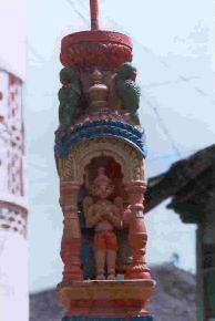
- Prakasha, one of the famous religious places, also known as Dakshin Kashi, is in Shahada Tehsil. The temple of Prakasha is very old.
- One of the famous temples of God Shree Ganesha (Heramb) is at Jaynagar, 24 km away from Shahada. Hundreds of thousands of people visit this temple on the occasion of Mangli Chathurthi.
- Shri Datta temple is at Sarangkheda. Every year a big fair is organised on the eve of Datta Jayanti which has main attraction of sale of horses.
- Umaj Mata temple is at Shinda. Every year a big fair is organised on the eve of Ashatami (December).
- Hingani is a small village between Shahada and Shirpur. People there conduct the "Mahavakya" & "Mahakavya" of the Mahanubhav panth.[11]
- Ashwashthama and Shanimandal religious places are also in this district.
- Dandapaneshwar Ganesh Mandir
- Devi Mogra Mata is mother goddess of Adivasis. Malda-Mogra Tal Taloda is famous village related to Devi Mogra mata.
- Saint Gulam Maharaj Ranjanpur Tal Taloda is Saint of adivasi, who took away them from addiction of alcohol.
- Toranmal 1076 mtr high pick is famous place for Navnath.
Dandapaneshwar tempal is one of the best place in Nandurbar¿
Demographics
According to the 2011 census Nandurbar district has a population of 1,646,177,[12] roughly equal to the nation of Guinea-Bissau[13] or the US state of Idaho.[14] This gives it a ranking of 304th in India (out of a total of 640).[12] The district has a population density of 276 inhabitants per square kilometre (710/sq mi) .[12] Its population growth rate over the decade 2001–2011 was 25.5%.[12] Nandurbar has a sex ratio of 972 females for every 1000 males,[12] and a literacy rate of 64.38%.[12]
Tourist places in Nandurbar District
- Toranmal is the second coolest hill station in Maharashtra state and is near Shahada (approx. 40 km). It is the second highest place in Maharashtra. It has a natural lake called Yashwant Lake which is natural and full of flowering lotus. It is a good place for sight-seeing and picnic.
- Asthamba one of the religious place of Nandurbar district is in Akrani Tahsil (also known as Dhadgaon). One of the popular fair of tribals from south Gujrat and north-west Maharashtra is the Asthamba fair. This fair is held during Diwali festival seasion for 10 to 15 days. Asthamba is a mythological character from Hindu epic called Mahabharat. Tribals say he is also known as Ashvasthama, a male character and son of Dronacharya. Nandurbar- Akkalkua- Dab- Valimba- Astamba) Approx. 70 km from Nandurbar.
- Unapdev (25 km from Shāhāda) is a pleasant picnic point in Shahada tehsil. It has a permanent natural hot water source, and it flows throughout the year from a structure in the shape of a cow's mouth.
References
- ↑ "Vehicle Registration Number – Useful info for car lover". Team-BHP. Retrieved 20 November 2010.
- ↑ "Census GIS India". Censusindiamaps.net. Retrieved 20 November 2010.
- ↑ "Aadhar – How to get your unique ID from the govt of India". The Times of India. 29 September 2010. Retrieved 3 October 2010.
- ↑ http://nandurbar.net/
- ↑ "Census of India 2001: Data from the 2001 Census, including cities, villages and towns (Provisional)". Census Commission of India. Archived from the original on 2004-06-16. Retrieved 2008-11-01.
- ↑ M. Paul Lewis, ed. (2009). "Ahirani: A language of India". Ethnologue: Languages of the World (16th ed.). Dallas, Texas: SIL International. Retrieved 28 September 2011.
- ↑ M. Paul Lewis, ed. (2009). "gujar is also indian language Bareli, Pauri: A language of India". Ethnologue: Languages of the World (16th ed.). Dallas, Texas: SIL International. Retrieved 28 September 2011.
- 1 2 Ministry of Panchayati Raj (8 September 2009). "A Note on the Backward Regions Grant Fund Programme" (PDF). National Institute of Rural Development. Retrieved 27 September 2011.
- 1 2 "The Gazetteers Department – DHULIA". Maharashtra.gov.in. Retrieved 20 November 2010.
- ↑ "Special Articles – Government of Maharashtra". Maharashtra.gov.in. Retrieved 20 November 2010.
- ↑ "Hinagani". Hingani.tripod.com. Retrieved 20 November 2010.
- 1 2 3 4 5 6 "District Census 2011". Census2011.co.in. 2011. Retrieved 30 September 2011.
- ↑ US Directorate of Intelligence. "Country Comparison:Population". Retrieved 1 October 2011.
Guinea-Bissau 1,596,677 July 2011 est.
- ↑ "2010 Resident Population Data". U.S. Census Bureau. Retrieved 30 September 2011.
Idaho 1,567,582
- "Nandurbar District". Government of Maharashtra.
- "History of Khandesh". Government of Maharashtra.
External links
| Wikimedia Commons has media related to Nandurbar district. |
 |
Narmada district, Gujarat | Chhota Udaipur district, Gujarat | Alirajpur district, Madhya Pradesh Barwani district, Madhya Pradesh |
|
| Tapi district, Gujarat | |
Dhule district | ||
| ||||
| | ||||
| Tapi district, Gujarat | Dhule district | Dhule district |
| Topics | |||||||||||||||||||||||
|---|---|---|---|---|---|---|---|---|---|---|---|---|---|---|---|---|---|---|---|---|---|---|---|
| Regions | |||||||||||||||||||||||
| Divisions and Districts |
| ||||||||||||||||||||||
| Million-plus cities in Maharashtra | |||||||||||||||||||||||
| Other cities with municipal corporations | |||||||||||||||||||||||
Portal: Maharashtra | |||||||||||||||||||||||