Alberta Highway 986
| ||||
|---|---|---|---|---|
 | ||||
| Route information | ||||
| Length: | 158 km[1] (98 mi) | |||
| Major junctions | ||||
| West end: |
| |||
| East end: |
| |||
| Location | ||||
| Specialized and rural municipalities: | County of Northern Lights, Northern Sunrise County | |||
| Highway system | ||||
|
Provincial highways in Alberta
| ||||

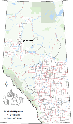
Alberta Provincial Highway No. 986[2] is an east-west highway in northern Alberta, Canada. It spans approximately 158 km (98 mi) from Highway 35 (Mackenzie Highway) to Highway 88 (Bicentennial Highway).[1][3]
Highway 986 comprises the western segment of the partially constructed "Northern Alberta East-West Highway Corridor".[4]
Route description
Highway 986 begins at Highway 35, approximately 21 km (13 mi) north of the Town of Grimshaw and 21 km (13 mi) south of the Hamlet of Dixonville within the County of Northern Lights. After intersecting Highway 743, the highway crosses the Peace River and enters Northern Sunrise County. A short distance later, the highway intersects Highway 688. It then continues east through the hamlets of Cadotte Lake and Little Buffalo before ending at Highway 88, approximately 10 km (6.2 mi) south of the Hamlet of Red Earth Creek.[1][3]
History
Highway 986 was originally numbered Highway 686. The highway was renumbered in the mid-1990s.[5][6]
Major intersections
The following is a list of major intersections along Highway 986 from west to east.[1][3]
| Municipality | km | Description | |||
|---|---|---|---|---|---|
| County of Northern Lights | 0 | | |||
| 20 | | ||||
| 30 | Crosses the Peace River | ||||
| Northern Sunrise County | 37 | | |||
| 158 | Ends at | ||||
| 1.000 mi = 1.609 km; 1.000 km = 0.621 mi | |||||
References
- 1 2 3 4 "2011 Provincial Highways 500 - 986 Progress Chart" (PDF). Alberta Transportation. March 2011. Retrieved 2011-07-15.
- ↑ Provincial Highways Designation Order, Alberta Transportation, p. 38
- 1 2 3 Alberta Official Road Map (Map) (2011 ed.). Alberta Tourism, Parks and Recreation. § F-3 & F-4.
- ↑ "Northern Highways Strategy – Building for Tomorrow Today ... Advancing the Alberta Economy" (PDF). Northern Alberta Development Council. October 2008. Retrieved 2011-07-17.
- ↑ Province of Alberta Canada Official Road Map (Map) (1994 ed.). Alberta Economic Development and Tourism. § F-3 & F-4.
- ↑ Province of Alberta Canada Official Road Map (Map) (1995 ed.). Alberta Economic Development and Tourism. § F-3 & F-4.
External links
- 2011 Provincial Highways 500 - 986 Progress Chart by Alberta Transportation.