Andert-et-Condon
| Andert-et-Condon | |
|---|---|
|
Chateau | |
 Andert-et-Condon | |
|
Location within Auvergne-Rhône-Alpes region  Andert-et-Condon | |
| Coordinates: 45°47′43″N 5°39′21″E / 45.7953°N 5.6558°ECoordinates: 45°47′43″N 5°39′21″E / 45.7953°N 5.6558°E | |
| Country | France |
| Region | Auvergne-Rhône-Alpes |
| Department | Ain |
| Arrondissement | Belley |
| Canton | Belley |
| Intercommunality | Bugey Sud |
| Government | |
| • Mayor (1995–2020) | Yves Delaruelle |
| Area1 | 6.94 km2 (2.68 sq mi) |
| Population (2009)2 | 336 |
| • Density | 48/km2 (130/sq mi) |
| Time zone | CET (UTC+1) |
| • Summer (DST) | CEST (UTC+2) |
| INSEE/Postal code | 01009 / 01300 |
| Elevation |
225–374 m (738–1,227 ft) (avg. 295 m or 968 ft) |
|
1 French Land Register data, which excludes lakes, ponds, glaciers > 1 km² (0.386 sq mi or 247 acres) and river estuaries. 2 Population without double counting: residents of multiple communes (e.g., students and military personnel) only counted once. | |
Andert-et-Condon is a French commune in the department of Ain in the Auvergne-Rhône-Alpes region of eastern France.
Geography
Located 6 km north-west of Belley (a sub-prefecture of Ain) and 40 km south-west of Amberieu-en-Bugey, Andert-et-Condon is a commune of 694 hectares. It is watered by the Furans. In addition to the village, the commune has several hamlets: Gevrin, Andert, and les Barraques et Bognens. The commune can be accessed by the D83 road from Contrevoz in the north-west which passes through the village continuing east to join the D1504 from Chazey-Bons to Belley. The D32 also passes though Contrevoz then passes through the south of the commune to Belley. the D32A comes from the north and through the village linking with the D32 in the south of the commune. The commune is mostly forest with some areas of farmland.[1]
The town lies within the Appellation d'origine contrôlée (AOC) zone for the wines of Bugey.
Neighbouring communes and villages[1]
 |
Contrevoz | Pugieu | Chazey-Bons | |
| |
Marignieu | |||
| ||||
| | ||||
| Saint-Germain-les-Paroisses | Arbignieu | Belley |
History
The area has been inhabited since the Chalcolithic and Roman periods. Excavations have found neolithic pottery. From 1180 to 1829 the Lordship of Andert played an important role in the region (the Dukes of Savoy - King of France). The tomb of François Andert Parra, provost of the constabulary of Bugey, is in the Andert chapel. This chapel dates from the 13th century with a stone dated from the 1st century. Andert and Condon were merged in 1791. Andert castle and Beauregard Manor overlook the road down to Contrevoz on the Furans. In 1838 on Andert bridge there was the mysterious drama of the Sébastien Benoit Peytel case which was defended by Balzac, Lamartine, and Gavarni.
Administration
List of Successive Mayors of Andert-et-Condons[2]
| From | To | Name | Party | Position |
|---|---|---|---|---|
| 1995 | 2020 | Yves Delaruelle |
(Not all data is known)
Demography
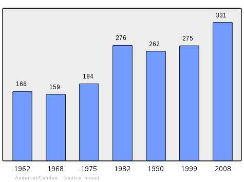
In 2008, Andert-et-Condon had 331 inhabitants (an increase of 4% compared to 1999). The town held the 21,077th place at the national level, while it was at 22,209th in 1999, and 310th out of 419 communes at the departmental level.
In 2009, the commune had 336 inhabitants. The evolution of the number of inhabitants is known through the population censuses conducted in the town since 1793. From the 21st century, a census of municipalities with fewer than 10,000 inhabitants is held every five years, unlike larger towns that have a sample survey every year.[Note 1]
| 1793 | 1800 | 1806 | 1821 | 1831 | 1836 | 1841 | 1846 | 1851 |
|---|---|---|---|---|---|---|---|---|
| 265 | 283 | 268 | 298 | 310 | 302 | 316 | 330 | 304 |
| 1856 | 1861 | 1866 | 1872 | 1876 | 1881 | 1886 | 1891 | 1896 |
|---|---|---|---|---|---|---|---|---|
| 311 | 309 | 330 | 321 | 282 | 278 | 376 | 333 | 331 |
| 1901 | 1906 | 1911 | 1921 | 1926 | 1931 | 1936 | 1946 | 1954 |
|---|---|---|---|---|---|---|---|---|
| 335 | 311 | 301 | 261 | 230 | 215 | 209 | 170 | 170 |
| 1962 | 1968 | 1975 | 1982 | 1990 | 1999 | 2006 | 2008 | 2009 |
|---|---|---|---|---|---|---|---|---|
| 166 | 159 | 184 | 276 | 262 | 275 | 319 | 331 | 336 |
Sources : Ldh/EHESS/Cassini until 1962, INSEE database from 1968 (population without double counting and municipal population from 2006)
Sites and Monuments
The commune has two sites which are registered as historical monuments:
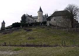
- The Chateau of Andert (15th century)
 [3]
[3] - The Chateau of Andert Park[4]
- At the south-eastern tip of the commune is the Pont de Bognens medieval bridge across the Furans river dating from 1290.[1]
See also
External links
- Andert-et-Condon on Lion1906
- Andert-et-Condon on Google Maps
- Andert-et-Condon on Géoportail, National Geographic Institute (IGN) website (French)
- Condon and Andert on the 1750 Cassini Map
- Andert-et-Condon on the INSEE website (French)
- INSEE (French)
Notes and references
Notes
- ↑ At the beginning of the 21st century, the methods of identification have been modified by law No. 2002-276 of 27 February 2002 , the so-called "law of local democracy" and in particular Title V "census operations" which allow, after a transitional period running from 2004 to 2008, the annual publication of the legal population of the different French administrative districts. For municipalities with a population greater than 10,000 inhabitants, a sample survey is conducted annually, the entire territory of these municipalities is taken into account at the end of the period of five years. The first "legal population" after 1999 under this new law came into force on 1 January 2009 and was based on the census of 2006.
References
- 1 2 3 Google Maps
- ↑ List of Mayors of France, consulted on 23 June 2010. (French)
- ↑ Ministry of Culture, Mérimée PA00116603 Chateau of Andert (French)

- ↑ Ministry of Culture, Mérimée IA01000326 Chateau of Andert Park (French)
| Wikimedia Commons has media related to Andert-et-Condon. |