Izernore
| Izernore | ||
|---|---|---|
|
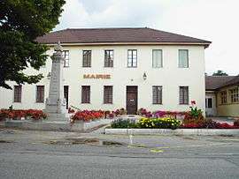
Town hall | ||
| ||
 Izernore | ||
|
Location within Auvergne-Rhône-Alpes region  Izernore | ||
| Coordinates: 46°13′00″N 5°33′00″E / 46.2167°N 5.55°ECoordinates: 46°13′00″N 5°33′00″E / 46.2167°N 5.55°E | ||
| Country | France | |
| Region | Auvergne-Rhône-Alpes | |
| Department | Ain | |
| Arrondissement | Nantua | |
| Canton | Izernore | |
| Intercommunality | Monts Berthiand | |
| Government | ||
| • Mayor (2008–2014) | Michel Colletaz | |
| Area1 | 20.86 km2 (8.05 sq mi) | |
| Population (2008)2 | 2,247 | |
| • Density | 110/km2 (280/sq mi) | |
| Time zone | CET (UTC+1) | |
| • Summer (DST) | CEST (UTC+2) | |
| INSEE/Postal code | 01192 / 01580 | |
| Elevation |
450–650 m (1,480–2,130 ft) (avg. 452 m or 1,483 ft) | |
|
1 French Land Register data, which excludes lakes, ponds, glaciers > 1 km² (0.386 sq mi or 247 acres) and river estuaries. 2 Population without double counting: residents of multiple communes (e.g., students and military personnel) only counted once. | ||
.svg.png)
Izernore is a commune in the Ain department in eastern France. An ancient Roman bronze hoard consisting of a patera and an oval dish was found in Izernore in 1845 and is now in the British Museum's collection.[1]
Izernore
Population
| Historical population | ||
|---|---|---|
| Year | Pop. | ±% |
| 1793 | 941 | — |
| 1800 | 978 | +3.9% |
| 1806 | 1,016 | +3.9% |
| 1821 | 1,057 | +4.0% |
| 1831 | 1,005 | −4.9% |
| 1836 | 985 | −2.0% |
| 1841 | 1,011 | +2.6% |
| 1846 | 1,103 | +9.1% |
| 1851 | 1,103 | +0.0% |
| 1856 | 1,084 | −1.7% |
| 1861 | 1,044 | −3.7% |
| 1866 | 1,011 | −3.2% |
| 1872 | 1,021 | +1.0% |
| 1876 | 1,064 | +4.2% |
| 1881 | 1,079 | +1.4% |
| 1886 | 1,129 | +4.6% |
| 1891 | 1,016 | −10.0% |
| 1896 | 932 | −8.3% |
| 1901 | 879 | −5.7% |
| 1906 | 757 | −13.9% |
| 1911 | 660 | −12.8% |
| 1921 | 633 | −4.1% |
| 1926 | 601 | −5.1% |
| 1931 | 563 | −6.3% |
| 1936 | 593 | +5.3% |
| 1946 | 553 | −6.7% |
| 1954 | 557 | +0.7% |
| 1962 | 548 | −1.6% |
| 1968 | 520 | −5.1% |
| 1975 | 682 | +31.2% |
| 1982 | 975 | +43.0% |
| 1990 | 1,170 | +20.0% |
| 1999 | 1,656 | +41.5% |
| 2008 | 2,247 | +35.7% |
Personalities
It was the birthplace of St. Eugendus (b. ca. 449).
See also
References
| Wikimedia Commons has media related to Izernore. |
This article is issued from Wikipedia - version of the 10/27/2016. The text is available under the Creative Commons Attribution/Share Alike but additional terms may apply for the media files.