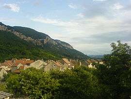
Villebois
| Villebois | |
|---|---|
 | |
 Villebois | |
|
Location within Auvergne-Rhône-Alpes region  Villebois | |
| Coordinates: 45°50′37″N 5°26′09″E / 45.8435°N 05.4358°ECoordinates: 45°50′37″N 5°26′09″E / 45.8435°N 05.4358°E | |
| Country | France |
| Region | Auvergne-Rhône-Alpes |
| Department | Ain |
| Arrondissement | Bourg-en-Bresse |
| Canton | Lagnieu |
| Intercommunality | Plaine de l'Ain |
| Government | |
| • Mayor (2008–2014) | Marc Longatte |
| Area1 | 14.46 km2 (5.58 sq mi) |
| Population (2008)2 | 1,111 |
| • Density | 77/km2 (200/sq mi) |
| Time zone | CET (UTC+1) |
| • Summer (DST) | CEST (UTC+2) |
| INSEE/Postal code | 01444 / 01150 |
| Elevation | 195–960 m (640–3,150 ft) |
|
1 French Land Register data, which excludes lakes, ponds, glaciers > 1 km² (0.386 sq mi or 247 acres) and river estuaries. 2 Population without double counting: residents of multiple communes (e.g., students and military personnel) only counted once. | |
For the locality in Canada, see Villebois, Quebec.
Villebois is a commune in the Ain department in eastern France.
Population
| Historical population | ||
|---|---|---|
| Year | Pop. | ±% |
| 1793 | 1,331 | — |
| 1800 | 926 | −30.4% |
| 1806 | 1,596 | +72.4% |
| 1821 | 1,501 | −6.0% |
| 1831 | 1,713 | +14.1% |
| 1836 | 1,795 | +4.8% |
| 1841 | 1,925 | +7.2% |
| 1846 | 2,163 | +12.4% |
| 1851 | 2,314 | +7.0% |
| 1856 | 2,522 | +9.0% |
| 1861 | 2,468 | −2.1% |
| 1866 | 2,518 | +2.0% |
| 1872 | 1,719 | −31.7% |
| 1876 | 1,705 | −0.8% |
| 1881 | 1,660 | −2.6% |
| 1886 | 1,718 | +3.5% |
| 1891 | 1,626 | −5.4% |
| 1896 | 1,491 | −8.3% |
| 1901 | 1,519 | +1.9% |
| 1906 | 1,474 | −3.0% |
| 1911 | 1,229 | −16.6% |
| 1921 | 1,068 | −13.1% |
| 1926 | 1,087 | +1.8% |
| 1931 | 1,062 | −2.3% |
| 1936 | 897 | −15.5% |
| 1946 | 797 | −11.1% |
| 1954 | 766 | −3.9% |
| 1962 | 775 | +1.2% |
| 1968 | 779 | +0.5% |
| 1975 | 758 | −2.7% |
| 1982 | 851 | +12.3% |
| 1990 | 924 | +8.6% |
| 1999 | 954 | +3.2% |
| 2008 | 1,111 | +16.5% |
See also
References
| Wikimedia Commons has media related to Villebois. |
This article is issued from Wikipedia - version of the 10/27/2016. The text is available under the Creative Commons Attribution/Share Alike but additional terms may apply for the media files.