Lélex
| Lélex | ||
|---|---|---|
|
Town hall | ||
| ||
 Lélex | ||
|
Location within Auvergne-Rhône-Alpes region  Lélex | ||
| Coordinates: 46°18′17″N 5°56′36″E / 46.3047°N 5.9433°ECoordinates: 46°18′17″N 5°56′36″E / 46.3047°N 5.9433°E | ||
| Country | France | |
| Region | Auvergne-Rhône-Alpes | |
| Department | Ain | |
| Arrondissement | Gex | |
| Canton | Gex | |
| Intercommunality | Pays de Gex | |
| Government | ||
| • Mayor (2008–2014) | Danièle Gabriel-Robez | |
| Area1 | 17.7 km2 (6.8 sq mi) | |
| Population (2008)2 | 225 | |
| • Density | 13/km2 (33/sq mi) | |
| Time zone | CET (UTC+1) | |
| • Summer (DST) | CEST (UTC+2) | |
| INSEE/Postal code | 01210 / 01410 | |
| Elevation |
720–1,703 m (2,362–5,587 ft) (avg. 889 m or 2,917 ft) | |
|
1 French Land Register data, which excludes lakes, ponds, glaciers > 1 km² (0.386 sq mi or 247 acres) and river estuaries. 2 Population without double counting: residents of multiple communes (e.g., students and military personnel) only counted once. | ||
_-_Mairie.JPG)

Lélex is a commune in the Ain department in eastern France.
Mountain sports
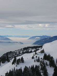
View from the top of the ski lift
Lélex is known as the highest ski resort of the Jura Mountains (1680 m).
Population
| Historical population | ||
|---|---|---|
| Year | Pop. | ±% |
| 1793 | 782 | — |
| 1800 | 794 | +1.5% |
| 1806 | 796 | +0.3% |
| 1821 | 512 | −35.7% |
| 1831 | 578 | +12.9% |
| 1836 | 563 | −2.6% |
| 1841 | 558 | −0.9% |
| 1846 | 529 | −5.2% |
| 1851 | 540 | +2.1% |
| 1856 | 530 | −1.9% |
| 1861 | 521 | −1.7% |
| 1866 | 546 | +4.8% |
| 1872 | 541 | −0.9% |
| 1876 | 520 | −3.9% |
| 1881 | 525 | +1.0% |
| 1886 | 518 | −1.3% |
| 1891 | 492 | −5.0% |
| 1896 | 485 | −1.4% |
| 1901 | 488 | +0.6% |
| 1906 | 484 | −0.8% |
| 1911 | 480 | −0.8% |
| 1921 | 382 | −20.4% |
| 1926 | 346 | −9.4% |
| 1931 | 280 | −19.1% |
| 1936 | 261 | −6.8% |
| 1946 | 189 | −27.6% |
| 1954 | 169 | −10.6% |
| 1962 | 156 | −7.7% |
| 1968 | 184 | +17.9% |
| 1975 | 183 | −0.5% |
| 1982 | 203 | +10.9% |
| 1990 | 232 | +14.3% |
| 1999 | 221 | −4.7% |
| 2008 | 225 | +1.8% |
See also
References
| Wikimedia Commons has media related to Lélex. |
This article is issued from Wikipedia - version of the 3/15/2016. The text is available under the Creative Commons Attribution/Share Alike but additional terms may apply for the media files.