Arbigny
| Arbigny | |
|---|---|
|
The Grand-Étang near Arbigny | |
 Arbigny | |
|
Location within Auvergne-Rhône-Alpes region  Arbigny | |
| Coordinates: 46°28′14″N 4°57′48″E / 46.4706°N 4.9633°ECoordinates: 46°28′14″N 4°57′48″E / 46.4706°N 4.9633°E | |
| Country | France |
| Region | Auvergne-Rhône-Alpes |
| Department | Ain |
| Arrondissement | Bourg-en-Bresse |
| Canton | Pont-de-Vaux |
| Intercommunality | Pont-de-Vaux |
| Government | |
| • Mayor (2014–2020) | Daniel Gras |
| Area1 | 17.47 km2 (6.75 sq mi) |
| Population (2010)2 | 399 |
| • Density | 23/km2 (59/sq mi) |
| Time zone | CET (UTC+1) |
| • Summer (DST) | CEST (UTC+2) |
| INSEE/Postal code | 01016 / 01190 |
| Elevation |
169–214 m (554–702 ft) (avg. 200 m or 660 ft) |
|
1 French Land Register data, which excludes lakes, ponds, glaciers > 1 km² (0.386 sq mi or 247 acres) and river estuaries. 2 Population without double counting: residents of multiple communes (e.g., students and military personnel) only counted once. | |
.jpg)
Arbigny is a French commune in the Ain department in the Auvergne-Rhône-Alpes region of eastern France.
The inhabitants of the commune are known as Arbignerons or Arbigneronnes[1]
Geography
Arbigny is some 20 km north of Mâcon and 40 km south by south-east of Chalon-sur-Saône. The commune can be accessed by the D933 from Sermoyer in the north passing through the centre of the commune and village and continuing south to Pont-de-Vaux. The D126 runs west from the village changing to the D163 at the border of the commune and continuing to Uchizy. There are two other hamlets in the commune - La Croix and La Varenne. About 80% of the commune is farmland with the rest being the forested eastern part.[2]
The western border of the commune is formed by the Saône river. In the north and east there are ponds which are drained by the Biel d'Etang Neuf and the Biel d'Etang Butière which flow west to the Saône.[2]
Neighbouring communes and villages
 |
Uchizy | Sermoyer | Romenay | |
| Montbellet | |
Vescours | ||
| ||||
| | ||||
| Viré | Pont-de-Vaux | Saint-Trivier-de-Courtes |
History
The area has been occupied since prehistoric times. The village was known as Albiniacus in the Middle Ages.
Administration
List of mayors of Arbigny[3]
| From | To | Name | Party | Position |
|---|---|---|---|---|
| 1995 | 2008 | Christian Berardet | ||
| 2008 | 2014 | Michel Vieux | ||
| 2014 | 2020 | Daniel Gras |
(Not all data is known)

Demography
In 2010 the commune had 399 inhabitants. The evolution of the number of inhabitants is known through the population censuses conducted in the town since 1793. From the 21st century, a census of municipalities with fewer than 10,000 inhabitants is held every five years, unlike larger towns that have a sample survey every year.[Note 1]
| 1793 | 1800 | 1806 | 1821 | 1831 | 1836 | 1841 | 1846 | 1851 |
|---|---|---|---|---|---|---|---|---|
| 933 | 720 | 1,055 | 866 | 911 | 897 | 890 | 857 | 922 |
| 1856 | 1861 | 1866 | 1872 | 1876 | 1881 | 1886 | 1891 | 1896 |
|---|---|---|---|---|---|---|---|---|
| 886 | 789 | 792 | 762 | 786 | 770 | 742 | 719 | 717 |
| 1901 | 1906 | 1911 | 1921 | 1926 | 1931 | 1936 | 1946 | 1954 |
|---|---|---|---|---|---|---|---|---|
| 725 | 708 | 702 | 572 | 535 | 522 | 513 | 468 | 451 |
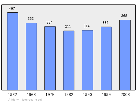
| 1962 | 1968 | 1975 | 1982 | 1990 | 1999 | 2006 | 2007 | 2008 |
|---|---|---|---|---|---|---|---|---|
| 407 | 353 | 334 | 311 | 314 | 332 | 349 | 352 | 368 |
| 2009 | 2010 | - | - | - | - | - | - | - |
|---|---|---|---|---|---|---|---|---|
| 383 | 399 | - | - | - | - | - | - | - |
Sources : Ldh/EHESS/Cassini until 1962, INSEE database from 1968 (population without double counting and municipal population from 2006)
Sites and monuments
.jpg)
- The remains of an old Fortified Chateau
- A Napoleonic milestone dated 1808
- A Stone marker commemorating the landing fields of the Royal Air Force during the Second World War, on the road to Uchizy just before the bridge over the Saône. The code name of the landing field was "JUNOT".
- A Plaque honouring two young resistance fighters (Dupasquier and Clairmidi) murdered by the Nazis in 1944 at a place called "La Varenne".
Protected natural areas
The floodplains of the Saône Valley have been classified as protected areas since 1994.[4]
See also
External links
- Arbigny on the old National Geographic Institute website (French)
- Arbigny on Lion1906
- Arbigny on Google Maps
- Arbigny on Géoportail, National Geographic Institute (IGN) website (French)
- Arbigny on the 1750 Cassini Map
- Arbigny on the INSEE website (French)
- INSEE (French)
Notes and references
Notes
- ↑ At the beginning of the 21st century, the methods of identification have been modified by law No. 2002-276 of 27 February 2002 , the so-called "law of local democracy" and in particular Title V "census operations" which allow, after a transitional period running from 2004 to 2008, the annual publication of the legal population of the different French administrative districts. For municipalities with a population greater than 10,000 inhabitants, a sample survey is conducted annually, the entire territory of these municipalities is taken into account at the end of the period of five years. The first "legal population" after 1999 under this new law came into force on 1 January 2009 and was based on the census of 2006.
References
- ↑ Inhabitants of Ain (French)
- 1 2 Google Maps
- ↑ List of Mayors of France (French)
- ↑ Protection Zone for the wetlands of the Saône Valley, Préfectoral directive of 25 February 1994, Préfecture of Ain (French)
| Wikimedia Commons has media related to Arbigny. |