Busigny
| Busigny | ||
|---|---|---|
 | ||
| ||
 Busigny | ||
|
Location within Hauts-de-France region  Busigny | ||
| Coordinates: 50°02′03″N 3°28′05″E / 50.0342°N 3.4681°ECoordinates: 50°02′03″N 3°28′05″E / 50.0342°N 3.4681°E | ||
| Country | France | |
| Region | Hauts-de-France | |
| Department | Nord | |
| Arrondissement | Cambrai | |
| Canton | Clary | |
| Intercommunality | Caudrésis–Catésis | |
| Government | ||
| • Mayor (2008–2014) | Christian Pecqueux | |
| Area1 | 16.47 km2 (6.36 sq mi) | |
| Population (2009)2 | 2,547 | |
| • Density | 150/km2 (400/sq mi) | |
| Time zone | CET (UTC+1) | |
| • Summer (DST) | CEST (UTC+2) | |
| INSEE/Postal code | 59118 / 59137 | |
| Elevation |
129–180 m (423–591 ft) (avg. 168 m or 551 ft) | |
|
1 French Land Register data, which excludes lakes, ponds, glaciers > 1 km² (0.386 sq mi or 247 acres) and river estuaries. 2 Population without double counting: residents of multiple communes (e.g., students and military personnel) only counted once. | ||
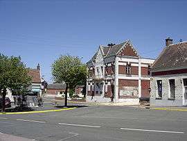
Busigny is a commune in the Nord department in northern France.
Population
| Historical population | ||
|---|---|---|
| Year | Pop. | ±% |
| 1793 | 1,465 | — |
| 1800 | 1,756 | +19.9% |
| 1806 | 1,834 | +4.4% |
| 1821 | 1,936 | +5.6% |
| 1831 | 2,275 | +17.5% |
| 1836 | 2,359 | +3.7% |
| 1841 | 2,425 | +2.8% |
| 1846 | 2,572 | +6.1% |
| 1851 | 2,788 | +8.4% |
| 1856 | 3,044 | +9.2% |
| 1861 | 3,412 | +12.1% |
| 1866 | 3,720 | +9.0% |
| 1872 | 3,540 | −4.8% |
| 1876 | 3,221 | −9.0% |
| 1881 | 3,086 | −4.2% |
| 1886 | 3,155 | +2.2% |
| 1891 | 3,046 | −3.5% |
| 1896 | 3,069 | +0.8% |
| 1901 | 2,753 | −10.3% |
| 1906 | 2,759 | +0.2% |
| 1911 | 2,768 | +0.3% |
| 1921 | 3,447 | +24.5% |
| 1926 | 3,548 | +2.9% |
| 1931 | 3,476 | −2.0% |
| 1936 | 3,240 | −6.8% |
| 1946 | 3,007 | −7.2% |
| 1954 | 2,999 | −0.3% |
| 1962 | 3,139 | +4.7% |
| 1968 | 3,120 | −0.6% |
| 1975 | 3,046 | −2.4% |
| 1982 | 2,636 | −13.5% |
| 1990 | 2,385 | −9.5% |
| 1999 | 2,420 | +1.5% |
| 2006 | 2,512 | +3.8% |
| 2009 | 2,547 | +1.4% |
Heraldry
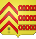 |
The arms of Busigny are blazoned : Or, 3 chevrons gules and in base a 'Croix de guerre 1939-1945' proper impaled with Or, 3 fesses gules billety Or |
See also
References
| Wikimedia Commons has media related to Busigny. |
This article is issued from Wikipedia - version of the 2/7/2014. The text is available under the Creative Commons Attribution/Share Alike but additional terms may apply for the media files.