Wattignies
For the village, also in Nord, which was the site of the Battle of Wattignies, see Wattignies-la-Victoire.
| Wattignies | |
|---|---|
 Wattignies | |
|
Location within Hauts-de-France region  Wattignies | |
| Coordinates: 50°35′08″N 3°02′38″E / 50.5856°N 3.0439°ECoordinates: 50°35′08″N 3°02′38″E / 50.5856°N 3.0439°E | |
| Country | France |
| Region | Hauts-de-France |
| Department | Nord |
| Arrondissement | Lille |
| Canton | Seclin-Nord |
| Intercommunality | Lille Métropole |
| Government | |
| • Mayor (2008–2014) | Alain Pluss |
| Area1 | 6.31 km2 (2.44 sq mi) |
| Population (1999)2 | 14,440 |
| • Density | 2,300/km2 (5,900/sq mi) |
| Time zone | CET (UTC+1) |
| • Summer (DST) | CEST (UTC+2) |
| INSEE/Postal code | 59648 / 59139 |
|
1 French Land Register data, which excludes lakes, ponds, glaciers > 1 km² (0.386 sq mi or 247 acres) and river estuaries. 2 Population without double counting: residents of multiple communes (e.g., students and military personnel) only counted once. | |
Wattignies (Dutch Wattenijs) is a commune in the Nord department of northern France. It lies to the south-west of the Lille conurbation. It covers an area of 6.31 square kilometres (2.44 sq mi), and as at 1999 its population was 14,440.
Neighboring communes
Lille, Faches-Thumesnil, Templemars, Seclin, Noyelles-lès-Seclin, Emmerin and Loos-lez-Lille.
Heraldry
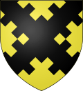 |
The arms of Wattignies are blazoned : Or, a saltire embattled counter-embattled sable. |
Twin towns
Wattignies is twinned with:
-
 Broadstairs, United Kingdom – since 1982
 -
 Rodenkirchen, Germany – since 1973
See also
References
External links
| Wikimedia Commons has media related to Wattignies. |
.svg.png)
This article is issued from Wikipedia - version of the 9/16/2016. The text is available under the Creative Commons Attribution/Share Alike but additional terms may apply for the media files.