Liessies
| Liessies | ||
|---|---|---|
 | ||
| ||
 Liessies | ||
|
Location within Hauts-de-France region  Liessies | ||
| Coordinates: 50°07′07″N 4°04′58″E / 50.1186°N 4.0828°ECoordinates: 50°07′07″N 4°04′58″E / 50.1186°N 4.0828°E | ||
| Country | France | |
| Region | Hauts-de-France | |
| Department | Nord | |
| Arrondissement | Avesnes-sur-Helpe | |
| Canton | Solre-le-Château | |
| Intercommunality | vallées de la Solre, de la Thure et de l'Helpe | |
| Government | ||
| • Mayor (2008–2014) | Alain Richard | |
| Area1 | 17.6 km2 (6.8 sq mi) | |
| Population (1999)2 | 501 | |
| • Density | 28/km2 (74/sq mi) | |
| Time zone | CET (UTC+1) | |
| • Summer (DST) | CEST (UTC+2) | |
| INSEE/Postal code | 59347 / 59740 | |
| Elevation |
157–234 m (515–768 ft) (avg. 182 m or 597 ft) | |
|
1 French Land Register data, which excludes lakes, ponds, glaciers > 1 km² (0.386 sq mi or 247 acres) and river estuaries. 2 Population without double counting: residents of multiple communes (e.g., students and military personnel) only counted once. | ||
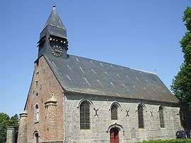
Liessies is a commune in the Nord department in northern France.
It is known for Liessies Abbey, of which the abbey church and the park have been preserved.
Heraldry
.svg.png) |
The arms of Liessies are blazoned : Argent, a boar's head erased sable, armed argent langued gules. (Liessies, Sains-du-Nord and Sémeries use the same arms.) |
See also
References
| Wikimedia Commons has media related to Liessies. |
This article is issued from Wikipedia - version of the 11/25/2016. The text is available under the Creative Commons Attribution/Share Alike but additional terms may apply for the media files.