Bartholomew County, Indiana
| Bartholomew County, Indiana | ||
|---|---|---|
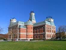 Bartholomew County courthouse in Columbus, Indiana | ||
| ||
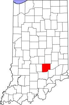 Location in the U.S. state of Indiana | ||
 Indiana's location in the U.S. | ||
| Founded | 12 February 1821 | |
| Named for | Joseph Bartholomew | |
| Seat | Columbus | |
| Largest city | Columbus | |
| Area | ||
| • Total | 409.52 sq mi (1,061 km2) | |
| • Land | 406.91 sq mi (1,054 km2) | |
| • Water | 2.62 sq mi (7 km2), 0.64% | |
| Population | ||
| • (2010) | 76,794 | |
| • Density | 189/sq mi (72.88/km²) | |
| Congressional district | 6th | |
| Time zone | Eastern: UTC-5/-4 | |
| Website |
www | |
| Footnotes: Indiana county number 3 | ||

Bartholomew County is a county located in the U.S. state of Indiana As of 2010, the population was 76,794.[1] The county seat is Columbus.[2] The county was determined by the U.S. Census Bureau to include the mean center of U.S. population in 1900.[3]
Bartholomew County is part of the Columbus, Indiana Metropolitan Statistical Area.
History
Bartholomew County was formed February 12, 1821 and was named for Lt. Col. Joseph Bartholomew, wounded at the Battle of Tippecanoe.[4] The site of the county seat was chosen on February 15, 1821 by a team of commissioners, who suggested the name Tiptona, in honor of John Tipton; on March 20, the name Columbus was adopted.
Courthouse
The current Bartholomew County courthouse was built from 1870 to 1874 by McCormack and Sweeney of Columbus at a cost of $225,000.
It was designed by architect Isaac Hodgson, who was born in Belfast, Ireland in 1826 and immigrated to the United States in 1848; he designed six Indiana courthouses, including the one in Henry County.
The courthouse is built largely of brick and has mansard roofs typical of the Second Empire French style. Its asymmetrical "L" shape allows it to face two major streets in Columbus. The inscription indicating the commissioners, architect and date is high up on the east facade.[5]
Today the Bartholomew County Veterans Memorial designed by American architect Charles Rose sits adjacent to the Courthouse.
Geography
According to the 2010 census, the county has a total area of 409.52 square miles (1,060.7 km2), of which 406.91 square miles (1,053.9 km2) (or 99.36%) is land and 2.62 square miles (6.8 km2) (or 0.64%) is water.[6] Camp Atterbury occupies the northwestern corner of the county.
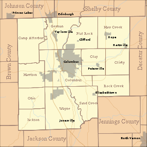
Adjacent counties
- Shelby County (northeast)
- Decatur County (east)
- Jennings County (southeast)
- Jackson County (south)
- Brown County (west)
- Johnson County (northwest)
Cities and towns
Unincorporated towns
Extinct towns
- Kansas
- South Bethany
Townships
Major highways
Airport
- KBAK - Columbus Municipal Airport
Railroads
Climate and weather
| Columbus, Indiana | ||||||||||||||||||||||||||||||||||||||||||||||||||||||||||||
|---|---|---|---|---|---|---|---|---|---|---|---|---|---|---|---|---|---|---|---|---|---|---|---|---|---|---|---|---|---|---|---|---|---|---|---|---|---|---|---|---|---|---|---|---|---|---|---|---|---|---|---|---|---|---|---|---|---|---|---|---|
| Climate chart (explanation) | ||||||||||||||||||||||||||||||||||||||||||||||||||||||||||||
| ||||||||||||||||||||||||||||||||||||||||||||||||||||||||||||
| ||||||||||||||||||||||||||||||||||||||||||||||||||||||||||||
In recent years, average temperatures in Columbus have ranged from a low of 19 °F (−7 °C) in January to a high of 86 °F (30 °C) in July, although a record low of −27 °F (−33 °C) was recorded in January 1912 and a record high of 111 °F (44 °C) was recorded in July 1934. Average monthly precipitation ranged from 2.63 inches (67 mm) in February to 4.63 inches (118 mm) in May.[7]
Government
| Bartholomew County Sheriff's Department | |
|---|---|
| Agency overview | |
| Legal personality | Governmental: Government agency |
| Jurisdictional structure | |
| Operations jurisdiction* | County (US) of Bartholomew in the state of Indiana, United States |
| Legal jurisdiction | As per operations jurisdiction. |
| General nature | |
| Operational structure | |
| Agency executive | Mark Gorbett, Sheriff |
| Footnotes | |
| * Divisional agency: Division of the country, over which the agency has usual operational jurisdiction. | |
The county government is a constitutional body, and is granted specific powers by the Constitution of Indiana, and by the Indiana Code.
County Council: The county council is the legislative branch of the county government and controls all the spending and revenue collection in the county. Representatives are elected from county districts. The council members serve four-year terms. They are responsible for setting salaries, the annual budget, and special spending. The council also has limited authority to impose local taxes, in the form of an income and property tax that is subject to state level approval, excise taxes, and service taxes.[8][9]
Board of Commissioners: The executive body of the county is made of a board of commissioners. The commissioners are elected county-wide, in staggered terms, and each serves a four-year term. One of the commissioners, typically the most senior, serves as president. The commissioners are charged with executing the acts legislated by the council, collecting revenue, and managing the day-to-day functions of the county government.[8][9]
Court: The county maintains a small claims court that can handle some civil cases. The judge on the court is elected to a term of four years and must be a member of the Indiana Bar Association. The judge is assisted by a constable who is also elected to a four-year term. In some cases, court decisions can be appealed to the state level circuit court.[9]
County Officials: The county has several other elected offices, including sheriff, coroner, auditor, treasurer, recorder, surveyor, and circuit court clerk. Each of these elected officers serves a term of four years and oversees a different part of county government. Members elected to county government positions are required to declare a party affiliation and to be residents of the county.[9]
Bartholomew County is part of Indiana's 6th congressional district and Indiana's 9th congressional district; Indiana Senate district 41;[10] and Indiana House of Representatives districts 57, 59 and 65.[11]
Demographics
| Historical population | |||
|---|---|---|---|
| Census | Pop. | %± | |
| 1830 | 5,476 | — | |
| 1840 | 10,042 | 83.4% | |
| 1850 | 12,428 | 23.8% | |
| 1860 | 17,865 | 43.7% | |
| 1870 | 21,133 | 18.3% | |
| 1880 | 22,777 | 7.8% | |
| 1890 | 23,867 | 4.8% | |
| 1900 | 24,594 | 3.0% | |
| 1910 | 24,813 | 0.9% | |
| 1920 | 23,887 | −3.7% | |
| 1930 | 24,864 | 4.1% | |
| 1940 | 28,276 | 13.7% | |
| 1950 | 36,108 | 27.7% | |
| 1960 | 48,198 | 33.5% | |
| 1970 | 57,022 | 18.3% | |
| 1980 | 65,088 | 14.1% | |
| 1990 | 63,657 | −2.2% | |
| 2000 | 71,435 | 12.2% | |
| 2010 | 76,794 | 7.5% | |
| Est. 2015 | 81,162 | [12] | 5.7% |
| U.S. Decennial Census[13] 1790-1960[14] 1900-1990[15] 1990-2000[16] 2010-2013[1] | |||
As of the 2010 United States Census, there were 76,794 people, 29,860 households, and 20,788 families residing in the county.[17] The population density was 188.7 inhabitants per square mile (72.9/km2). There were 33,098 housing units at an average density of 81.3 per square mile (31.4/km2).[6] The racial makeup of the county was 89.6% white, 3.4% Asian, 1.8% black or African American, 0.3% American Indian, 0.1% Pacific islander, 3.2% from other races, and 1.6% from two or more races. Those of Hispanic or Latino origin made up 6.2% of the population.[17] In terms of ancestry, 28.5% were German, 12.4% were English, 12.2% were Irish, and 10.7% were American.[18]
Of the 29,860 households, 34.6% had children under the age of 18 living with them, 54.1% were married couples living together, 10.7% had a female householder with no husband present, 30.4% were non-families, and 25.3% of all households were made up of individuals. The average household size was 2.53 and the average family size was 3.02. The median age was 38.2 years.[17]
The median income for a household in the county was $47,697 and the median income for a family was $64,024. Males had a median income of $50,358 versus $32,334 for females. The per capita income for the county was $26,860. About 7.7% of families and 10.4% of the population were below the poverty line, including 15.8% of those under age 18 and 5.3% of those age 65 or over.[19]
Education
Public schools in Bartholomew County are administered by the Bartholomew Consolidated School Corporation and the Flat Rock-Hawcreek School Corporation. The county's first tuition-free public charter school, the International School of Columbus, a middle school/high school, opened in 2009-10. The ISC was an International Baccalaureate World School offering the Diploma Program. The ISC closed due to financial difficulties in the fall of 2013.
See also
- The Republic, daily newspaper covering Bartholomew County
- National Register of Historic Places listings in Bartholomew County, Indiana
References
- 1 2 "Bartholomew County QuickFacts". United States Census Bureau. Retrieved 2011-09-17.
- ↑ "Find a County". National Association of Counties. Archived from the original on 2012-07-12. Retrieved 2011-06-07.
- ↑ "Mean Center of Population for the United States: 1790 to 2000" (PDF). United States Census Bureau. Retrieved 2011-09-17.
- ↑ Baker, Ronald L.; Carmony, Marvin (1975). Indiana Place Names. Bloomington, Indiana: Indiana University Press. p. 9.
- ↑ Counts, Will; Jon Dilts (1991). The 92 Magnificent Indiana Courthouses. Bloomington, Indiana: Indiana University Press. pp. 12–13. ISBN 978-0-253-33638-5.
- 1 2 "Population, Housing Units, Area, and Density: 2010 - County". United States Census Bureau. Retrieved 2015-07-10.
- 1 2 "Monthly Averages for Columbus, Indiana". The Weather Channel. Retrieved 2011-01-27.
- 1 2 Indiana Code. "Title 36, Article 2, Section 3". IN.gov. Archived from the original on 5 October 2008. Retrieved 2008-09-16.
- 1 2 3 4 Indiana Code. "Title 2, Article 10, Section 2" (PDF). IN.gov. Archived (PDF) from the original on 29 October 2008. Retrieved 2008-09-16.
- ↑ "Indiana Senate Districts". State of Indiana. Archived from the original on 15 January 2011. Retrieved 2011-01-23.
- ↑ "Indiana House Districts". State of Indiana. Archived from the original on 15 January 2011. Retrieved 2011-01-23.
- ↑ "County Totals Dataset: Population, Population Change and Estimated Components of Population Change: April 1, 2010 to July 1, 2015". Retrieved July 2, 2016.
- ↑ "U.S. Decennial Census". United States Census Bureau. Archived from the original on May 11, 2015. Retrieved July 10, 2014.
- ↑ "Historical Census Browser". University of Virginia Library. Retrieved July 10, 2014.
- ↑ "Population of Counties by Decennial Census: 1900 to 1990". United States Census Bureau. Retrieved July 10, 2014.
- ↑ "Census 2000 PHC-T-4. Ranking Tables for Counties: 1990 and 2000" (PDF). United States Census Bureau. Retrieved July 10, 2014.
- 1 2 3 "DP-1 Profile of General Population and Housing Characteristics: 2010 Demographic Profile Data". United States Census Bureau. Retrieved 2015-07-10.
- ↑ "DP02 SELECTED SOCIAL CHARACTERISTICS IN THE UNITED STATES – 2006-2010 American Community Survey 5-Year Estimates". United States Census Bureau. Retrieved 2015-07-10.
- ↑ "DP03 SELECTED ECONOMIC CHARACTERISTICS – 2006-2010 American Community Survey 5-Year Estimates". United States Census Bureau. Retrieved 2015-07-10.
External links
- Bartholomew County official website
- Bartholomew Consolidated School Corporation
- Flat Rock-Hawcreek School Corporation
- International School of Columbus
 |
Johnson County | Shelby County | | |
| Brown County | |
Decatur County | ||
| ||||
| | ||||
| Jackson County | Jennings County |
Municipalities and communities of Bartholomew County, Indiana, United States | ||
|---|---|---|
| City | ||
| Towns | ||
| Townships | ||
| CDP | ||
| Other unincorporated communities |
| |
| Footnotes | ‡This populated place also has portions in an adjacent county or counties | |

Coordinates: 39°13′N 85°54′W / 39.21°N 85.90°W