Coray
| Coray Kore | ||
|---|---|---|
|
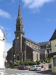
The church in Coray | ||
| ||
 Coray | ||
|
Location within Brittany region  Coray | ||
| Coordinates: 48°03′43″N 3°49′43″W / 48.0619°N 3.8286°WCoordinates: 48°03′43″N 3°49′43″W / 48.0619°N 3.8286°W | ||
| Country | France | |
| Region | Brittany | |
| Department | Finistère | |
| Arrondissement | Châteaulin | |
| Canton | Châteauneuf-du-Faou | |
| Intercommunality | Haute Cornouaille | |
| Government | ||
| • Mayor (2014–2020) | Henriette Le Brigand | |
| Area1 | 31.36 km2 (12.11 sq mi) | |
| Population (2008)2 | 1,805 | |
| • Density | 58/km2 (150/sq mi) | |
| Time zone | CET (UTC+1) | |
| • Summer (DST) | CEST (UTC+2) | |
| INSEE/Postal code | 29041 / 29370 | |
| Elevation | 75–257 m (246–843 ft) | |
|
1 French Land Register data, which excludes lakes, ponds, glaciers > 1 km² (0.386 sq mi or 247 acres) and river estuaries. 2 Population without double counting: residents of multiple communes (e.g., students and military personnel) only counted once. | ||
.svg.png)
Coray (Kore in Breton) is a commune in the Finistère department of Brittany in north-western France.
It lies on the Odet river.
Population
Inhabitants of Coray are called in French Corayens.
| Year | 1800 | 1821 | 1831 | 1836 | 1841 | 1846 | 1851 | 1856 | 1861 | 1866 |
|---|---|---|---|---|---|---|---|---|---|---|
| Population | 1488 | 1443 | 1640 | 1847 | 1834 | 1809 | 1976 | 1855 | 1992 | 2139 |
| Year | 1872 | 1876 | 1881 | 1886 | 1891 | 1896 | 1901 | 1906 | 1911 | 1921 |
|---|---|---|---|---|---|---|---|---|---|---|
| Population | 2076 | 2275 | 2410 | 2532 | 2572 | 2565 | 2760 | 2705 | 2752 | 2445 |
| Year | 1926 | 1931 | 1936 | 1946 | 1954 | 1962 | 1968 | 1975 | 1982 | 1990 |
|---|---|---|---|---|---|---|---|---|---|---|
| Population | 2366 | 2189 | 2127 | 2049 | 2006 | 1841 | 1787 | 1768 | 1737 | 1623 |
| Year | 1999 | 2008 |
|---|---|---|
| Population | 1625 | 1805 |
See also
References
- Mayors of Finistère Association (French);
External links
| Wikimedia Commons has media related to Coray. |
- Official website (French)
- French Ministry of Culture list for Coray (French)
This article is issued from Wikipedia - version of the 2/12/2016. The text is available under the Creative Commons Attribution/Share Alike but additional terms may apply for the media files.