Moëlan-sur-Mer
| Moëlan-sur-Mer Molan | ||
|---|---|---|
|
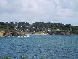
The beach at Kerfany-les-Pins, in Moëlan-sur-Mer | ||
| ||
 Moëlan-sur-Mer | ||
|
Location within Brittany region  Moëlan-sur-Mer | ||
| Coordinates: 47°48′54″N 3°37′37″W / 47.8150°N 3.6269°WCoordinates: 47°48′54″N 3°37′37″W / 47.8150°N 3.6269°W | ||
| Country | France | |
| Region | Brittany | |
| Department | Finistère | |
| Arrondissement | Quimper | |
| Canton | Pont-Aven | |
| Intercommunality | Pays de Quimperlé | |
| Government | ||
| • Mayor (2014–2020) | Marcel Le Pennec | |
| Area1 | 47.30 km2 (18.26 sq mi) | |
| Population (2013)2 | 7,033 | |
| • Density | 150/km2 (390/sq mi) | |
| Time zone | CET (UTC+1) | |
| • Summer (DST) | CEST (UTC+2) | |
| INSEE/Postal code | 29150 / 29350 | |
| Elevation | 0–67 m (0–220 ft) | |
|
1 French Land Register data, which excludes lakes, ponds, glaciers > 1 km² (0.386 sq mi or 247 acres) and river estuaries. 2 Population without double counting: residents of multiple communes (e.g., students and military personnel) only counted once. | ||

Moëlan-sur-Mer (Breton: Molan) is a commune in the Finistère department and administrative region of Brittany in north-western France.
Population
In French the inhabitants of Moëlan-sur-Mer are known as Moëlanais.
| Year | 1793 | 1800 | 1806 | 1821 | 1831 | 1836 | 1841 | 1846 | 1851 | 1856 |
|---|---|---|---|---|---|---|---|---|---|---|
| Population | 3103 | 3258 | 3609 | 3656 | 3839 | 4201 | 4132 | 4325 | 4432 | 4370 |
| Year | 1861 | 1866 | 1872 | 1876 | 1881 | 1886 | 1891 | 1896 | 1901 | 1906 |
|---|---|---|---|---|---|---|---|---|---|---|
| Population | 4360 | 4595 | 4653 | 4963 | 5213 | 5410 | 5481 | 5726 | 5887 | 6315 |
| Year | 1911 | 1921 | 1926 | 1931 | 1936 | 1946 | 1954 | 1962 | 1968 | 1975 |
|---|---|---|---|---|---|---|---|---|---|---|
| Population | 6640 | 6720 | 6659 | 6520 | 6543 | 6810 | 6517 | 6653 | 6276 | 6297 |
| Year | 1982 | 1990 | 1999 | 2008 | 2013 |
|---|---|---|---|---|---|
| Population | 6501 | 6596 | 6592 | 6932 | 7033 |
See also
- Communes of the Finistère department
- Jean Joncourt, sculptor of the local war memorial
References
- INSEE
- Mayors of Finistère Association (French)
External links
| Wikimedia Commons has media related to Moëlan-sur-Mer. |
- Official website (French)
- French Ministry of Culture list for Moëlan-sur-Mer (French)
This article is issued from Wikipedia - version of the 11/3/2016. The text is available under the Creative Commons Attribution/Share Alike but additional terms may apply for the media files.