Le Tréhou
| Le Tréhou An Treoù-Leon | ||
|---|---|---|
|
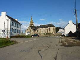
The main road and the parish church of Sainte-Pitère | ||
| ||
 Le Tréhou | ||
|
Location within Brittany region  Le Tréhou | ||
| Coordinates: 48°23′41″N 4°07′47″W / 48.3947°N 4.1297°WCoordinates: 48°23′41″N 4°07′47″W / 48.3947°N 4.1297°W | ||
| Country | France | |
| Region | Brittany | |
| Department | Finistère | |
| Arrondissement | Brest | |
| Canton | Ploudiry | |
| Intercommunality | Pays de Landerneau-Daoulas | |
| Government | ||
| • Mayor (2014–2020) | Joël Cann | |
| Area1 | 22.79 km2 (8.80 sq mi) | |
| Population (2008)2 | 539 | |
| • Density | 24/km2 (61/sq mi) | |
| Time zone | CET (UTC+1) | |
| • Summer (DST) | CEST (UTC+2) | |
| INSEE/Postal code | 29294 / 29450 | |
| Elevation | 35–171 m (115–561 ft) | |
|
1 French Land Register data, which excludes lakes, ponds, glaciers > 1 km² (0.386 sq mi or 247 acres) and river estuaries. 2 Population without double counting: residents of multiple communes (e.g., students and military personnel) only counted once. | ||
.svg.png)
Le Tréhou (Breton: An Treoù-Leon) is a commune in the Finistère department of Brittany in north-western France.
Population
Inhabitants of Le Tréhou are called in French Tréhousiens.
| Year | 1793 | 1800 | 1806 | 1821 | 1831 | 1836 | 1841 | 1846 | 1851 | 1856 |
|---|---|---|---|---|---|---|---|---|---|---|
| Population | 1077 | 1054 | 1068 | 1045 | 1072 | 1106 | 1120 | 1184 | 1169 | 1169 |
| Year | 1861 | 1866 | 1872 | 1876 | 1881 | 1886 | 1891 | 1896 | 1901 | 1906 |
|---|---|---|---|---|---|---|---|---|---|---|
| Population | 1172 | 1213 | 1163 | 1272 | 1198 | 1228 | 1167 | 1134 | 1046 | 1027 |
| Year | 1911 | 1921 | 1926 | 1931 | 1936 | 1946 | 1954 | 1962 | 1968 | 1975 |
|---|---|---|---|---|---|---|---|---|---|---|
| Population | 1084 | 1061 | 1003 | 926 | 856 | 774 | 671 | 619 | 596 | 527 |
| Year | 1982 | 1990 | 1999 | 2008 |
|---|---|---|---|---|
| Population | 453 | 395 | 408 | 539 |
See also
- List of the works of Bastien and Henry Prigent
- Communes of the Finistère department
- Le Tréhou Parish close
References
External links
| Wikimedia Commons has media related to Le Tréhou. |
- Official website (French)
- French Ministry of Culture list for Le Tréhou (French)
This article is issued from Wikipedia - version of the 7/31/2015. The text is available under the Creative Commons Attribution/Share Alike but additional terms may apply for the media files.