Trégunc
| Trégunc Tregon | |
|---|---|
|
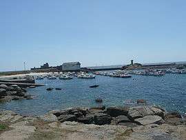
The harbour of Trévignon | |
 Trégunc | |
|
Location within Brittany region  Trégunc | |
| Coordinates: 47°51′23″N 3°51′02″W / 47.8564°N 3.8506°WCoordinates: 47°51′23″N 3°51′02″W / 47.8564°N 3.8506°W | |
| Country | France |
| Region | Brittany |
| Department | Finistère |
| Arrondissement | Quimper |
| Canton | Concarneau |
| Intercommunality | Concarneau-Cornouaille |
| Government | |
| • Mayor (2014–2020) | Olivier Bellec |
| Area1 | 50.61 km2 (19.54 sq mi) |
| Population (2008)2 | 6,799 |
| • Density | 130/km2 (350/sq mi) |
| Time zone | CET (UTC+1) |
| • Summer (DST) | CEST (UTC+2) |
| INSEE/Postal code | 29293 / 29910 |
| Elevation | 0–89 m (0–292 ft) |
|
1 French Land Register data, which excludes lakes, ponds, glaciers > 1 km² (0.386 sq mi or 247 acres) and river estuaries. 2 Population without double counting: residents of multiple communes (e.g., students and military personnel) only counted once. | |
Trégunc (Breton: Tregon) is a commune in the Finistère department of Brittany in western France.
Population
Inhabitants of Trégunc are called in French Trégunois or Tréguncois.
| Historical population | ||
|---|---|---|
| Year | Pop. | ±% |
| 1793 | 2,146 | — |
| 1800 | 2,522 | +17.5% |
| 1806 | 2,531 | +0.4% |
| 1821 | 2,782 | +9.9% |
| 1831 | 3,029 | +8.9% |
| 1836 | 3,086 | +1.9% |
| 1841 | 3,204 | +3.8% |
| 1846 | 3,462 | +8.1% |
| 1851 | 3,481 | +0.5% |
| 1856 | 3,540 | +1.7% |
| 1861 | 3,484 | −1.6% |
| 1866 | 3,528 | +1.3% |
| 1872 | 3,600 | +2.0% |
| 1876 | 3,697 | +2.7% |
| 1881 | 3,809 | +3.0% |
| 1886 | 3,860 | +1.3% |
| 1891 | 4,165 | +7.9% |
| 1896 | 4,470 | +7.3% |
| 1901 | 4,703 | +5.2% |
| 1906 | 4,848 | +3.1% |
| 1911 | 4,991 | +2.9% |
| 1921 | 4,763 | −4.6% |
| 1926 | 4,878 | +2.4% |
| 1931 | 4,675 | −4.2% |
| 1936 | 4,802 | +2.7% |
| 1946 | 4,889 | +1.8% |
| 1954 | 4,795 | −1.9% |
| 1962 | 5,002 | +4.3% |
| 1968 | 4,790 | −4.2% |
| 1975 | 5,155 | +7.6% |
| 1982 | 5,909 | +14.6% |
| 1990 | 6,130 | +3.7% |
| 1999 | 6,357 | +3.7% |
| 2008 | 6,799 | +7.0% |
Cultural heritage
- Saint-Philibert's chapel (Trégunc): 16th-century chapel.
- Chateau de Kerminaouet
Breton language
In 2008, 7.19% of primary-school children attended bilingual schools.[1]
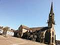
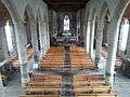
Gallery

.jpg)
.jpg)
See also
References
- ↑ (French) Ofis ar Brezhoneg: Enseignement bilingue
- Mayors of Finistère Association (French)
External links
| Wikimedia Commons has media related to Trégunc. |
- Official website (English)/(French)
- French Ministry of Culture list for Trégunc (French)
This article is issued from Wikipedia - version of the 3/15/2016. The text is available under the Creative Commons Attribution/Share Alike but additional terms may apply for the media files.