Flint Hill, Rappahannock County, Virginia
| Flint Hill, Virginia | |
|---|---|
| Census-designated place (CDP) | |
|
A view of Flint Hill along Zachary Taylor Highway | |
 Location within the Commonwealth of Virginia | |
| Coordinates: 38°46′2.76″N 78°5′1.46″W / 38.7674333°N 78.0837389°WCoordinates: 38°46′2.76″N 78°5′1.46″W / 38.7674333°N 78.0837389°W | |
| Country | United States |
| State | Virginia |
| County | Rappahannock |
| Population (2010 Census) | |
| • Total | 209 |
| Time zone | Eastern (EST) (UTC-5) |
| • Summer (DST) | EDT (UTC-4) |
| ZIP code | 22627 |
| Area code(s) | 540 |
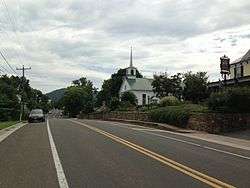
Flint Hill is a census-designated place (CDP) in Rappahannock County, Virginia, United States. The population as of the 2010 Census was 209.[1] It is located on Route 522, approximately 2 miles to the east of the border of the Shenandoah National Park.
Most of the village, including a two-mile stretch of Route 522 between Wilson Branch Creek and Ben Venue Road and portions of several side streets, was listed on the National Register of Historic Places in 2012 as the Flint Hill Historic District. The Caledonia Farm and the Flint Hill Baptist Church are also separately listed on the National Register of Historic Places.[2]
References
- ↑ "American FactFinder". United States Census Bureau. Retrieved 2011-05-14.
- ↑ National Park Service (2010-07-09). "National Register Information System". National Register of Historic Places. National Park Service.
- "Virginia Trend Report 2: State and Complete Places (Sub-state 2010 Census Data). Missouri Census Data Center.". Retrieved 8 June 2011.
- "Flint Hill - Virginia Is For Lovers". Retrieved 17 June 2010.
- "NRHP nomination for Flint Hill Historic District" (PDF). Virginia DHR. Retrieved 12 March 2014.
Municipalities and communities of Rappahannock County, Virginia, United States | ||
|---|---|---|
| Town | 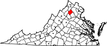 | |
| CDPs | ||
| Unincorporated communities |
| |
| Footnotes | ‡This populated place also has portions in an adjacent county or counties | |


This article is issued from Wikipedia - version of the 9/5/2016. The text is available under the Creative Commons Attribution/Share Alike but additional terms may apply for the media files.