National Register of Historic Places listings in Dinwiddie County, Virginia
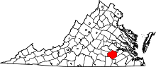
Location of Dinwiddie County in Virginia
This is a list of the National Register of Historic Places listings in Dinwiddie County, Virginia.
This is intended to be a complete list of the properties and districts on the National Register of Historic Places in Dinwiddie County, Virginia, United States. The locations of National Register properties and districts for which the latitude and longitude coordinates are included below, may be seen in a Google map.[1]
There are 19 properties and districts listed on the National Register in the county, including 2 National Historic Landmarks.
- This National Park Service list is complete through NPS recent listings posted December 2, 2016.[2]
Current listings
| [3] |
Name on the Register[4] |
Image |
Date listed[5] |
Location |
City or town |
Description |
|---|
| 1 |
Burlington |
Upload image |
000000001976-04-30-0000April 30, 1976
(#76002102) |
W of Petersburg off VA 600
37°13′19″N 77°28′14″W / 37.221944°N 77.470556°W / 37.221944; -77.470556 (Burlington) |
Petersburg |
|
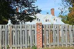
| 2 |
Burnt Quarter |
|
000000001969-11-25-0000November 25, 1969
(#69000235) |
Southwest of the junction of Routes 627, 613, and 645
37°08′19″N 77°37′30″W / 37.138611°N 77.625°W / 37.138611; -77.625 (Burnt Quarter) |
Dinwiddie |
|
| 3 |
Butterwood Methodist Church and Butterwood Cemetery |
Upload image |
000000002003-04-11-0000April 11, 2003
(#03000213) |
VA 40
37°04′21″N 77°51′41″W / 37.0725°N 77.861389°W / 37.0725; -77.861389 (Butterwood Methodist Church and Butterwood Cemetery) |
Blackstone |
|
| 4 |
Central State Hospital Chapel |
|
000000002010-09-24-0000September 24, 2010
(#10000794) |
West Washington Street Extended
37°12′28″N 77°27′10″W / 37.2079122029609°N 77.452734948242°W / 37.2079122029609; -77.452734948242 (Central State Hospital Chapel) |
Petersburg |
|
| 5 |
Conover Archaeological Site |
Upload image |
000000001985-03-28-0000March 28, 1985
(#85000647) |
Address Restricted
|
Carson |
|
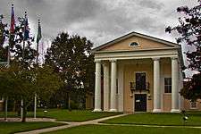
| 6 |
Dinwiddie County Court House |
|
000000001973-03-21-0000March 21, 1973
(#73002008) |
Jct. of U.S. 1 and VA 619
37°04′37″N 77°35′14″W / 37.076944°N 77.587222°W / 37.076944; -77.587222 (Dinwiddie County Court House) |
Dinwiddie |
|
| 7 |
Five Forks Battlefield |
|
000000001966-10-15-0000October 15, 1966
(#66000830) |
12 mi. W of Petersburg on CR 627 at Church Rd.
37°08′29″N 77°36′48″W / 37.141389°N 77.613333°W / 37.141389; -77.613333 (Five Forks Battlefield) |
Petersburg |
|
| 8 |
Mansfield |
|
000000001976-05-28-0000May 28, 1976
(#76002103) |
West of Petersburg on Mark Dr.
37°13′15″N 77°29′18″W / 37.220833°N 77.488333°W / 37.220833; -77.488333 (Mansfield) |
Petersburg |
|
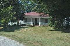
| 9 |
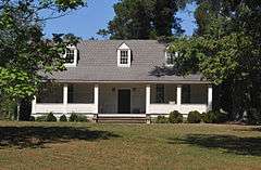
Mayfield Cottage |
|
000000001969-11-12-0000November 12, 1969
(#69000236) |
Central State Hospital Grounds
37°12′50″N 77°26′52″W / 37.213889°N 77.447778°W / 37.213889; -77.447778 (Mayfield Cottage) |
Petersburg |
|
| 10 |
Montrose |
|
000000002004-08-11-0000August 11, 2004
(#04000855) |
19216 Old White Oak Rd.
37°00′28″N 77°46′39″W / 37.007778°N 77.7775°W / 37.007778; -77.7775 (Montrose) |
McKenney |
|
| 11 |
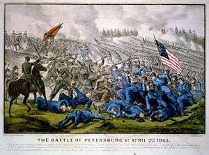
Petersburg Breakthrough Battlefield |
|
000000002006-02-17-0000February 17, 2006
(#06000239) |
Jct. of Duncan and Boydton Plank Rds.
37°11′22″N 77°28′33″W / 37.189511°N 77.475722°W / 37.189511; -77.475722 (Petersburg Breakthrough Battlefield) |
Petersburg |
Site of the Third Battle of Petersburg.
|
| 12 |
Petersburg Breakthrough Battlefield Historic District at Pamplin Historical Park |
|
000000002003-10-22-0000October 22, 2003
(#03001095) |
6125 Boydton Plank Rd., 6619 Duncan Rd.
37°11′00″N 77°28′24″W / 37.183333°N 77.473333°W / 37.183333; -77.473333 (Petersburg Breakthrough Battlefield Historic District at Pamplin Historical Park) |
Petersburg |
A portion of the site of the Third Battle of Petersburg.
|
| 13 |
Petersburg National Battlefield |
|
000000001966-10-15-0000October 15, 1966
(#66000831) |
SE, S, and SW of Petersburg
37°13′49″N 77°21′47″W / 37.230278°N 77.363056°W / 37.230278; -77.363056 (Petersburg National Battlefield) |
Petersburg |
|
| 14 |
Rose Bower |
Upload image |
000000001991-02-05-0000February 5, 1991
(#91000020) |
VA 665 S of jct. with VA 40
36°56′10″N 77°32′28″W / 36.936111°N 77.541111°W / 36.936111; -77.541111 (Rose Bower) |
Stony Creek |
|
| 15 |
Sappony Church |
|
000000001976-04-30-0000April 30, 1976
(#76002101) |
S of Sappony Creek off VA 692
36°58′14″N 77°38′10″W / 36.970556°N 77.636111°W / 36.970556; -77.636111 (Sappony Church) |
McKenney |
|
| 16 |
Stony Creek Plantation |
Upload image |
000000002003-04-11-0000April 11, 2003
(#03000212) |
VA 624
37°05′33″N 77°39′31″W / 37.0925°N 77.658611°W / 37.0925; -77.658611 (Stony Creek Plantation) |
DeWitt |
|
| 17 |
Wales |
|
000000001974-12-23-0000December 23, 1974
(#74002115) |
W of Petersburg off VA 632
37°11′27″N 77°30′31″W / 37.190833°N 77.508611°W / 37.190833; -77.508611 (Wales) |
Petersburg |
|
| 18 |
Williamson Site |
Upload image |
000000001969-12-03-0000December 3, 1969
(#69000237) |
Address Restricted
|
Dinwiddie |
|
| 19 |
Zehmer Farm |
|
000000002009-09-30-0000September 30, 2009
(#09000793) |
9818 Jack Zehmer Rd.
36°59′04″N 77°43′44″W / 36.984378°N 77.728911°W / 36.984378; -77.728911 (Zehmer Farm) |
McKenney |
|
See also
References
- ↑ The latitude and longitude information provided in this table was derived originally from the National Register Information System, which has been found to be fairly accurate for about 99% of listings. For about 1% of NRIS original coordinates, experience has shown that one or both coordinates are typos or otherwise extremely far off; some corrections may have been made. A more subtle problem causes many locations to be off by up to 150 yards, depending on location in the country: most NRIS coordinates were derived from tracing out latitude and longitudes off of USGS topographical quadrant maps created under the North American Datum of 1927, which differs from the current, highly accurate WGS84 GPS system used by most on-line maps. Chicago is about right, but NRIS longitudes in Washington are higher by about 4.5 seconds, and are lower by about 2.0 seconds in Maine. Latitudes differ by about 1.0 second in Florida. Some locations in this table may have been corrected to current GPS standards.
- ↑ "National Register of Historic Places: Weekly List Actions". National Park Service, United States Department of the Interior. Retrieved on December 2, 2016.
- ↑ Numbers represent an ordering by significant words. Various colorings, defined here, differentiate National Historic Landmarks and historic districts from other NRHP buildings, structures, sites or objects.
- ↑ National Park Service (2008-04-24). "National Register Information System". National Register of Historic Places. National Park Service.
- ↑ The eight-digit number below each date is the number assigned to each location in the National Register Information System database, which can be viewed by clicking the number.
|
|---|
|
Lists
by county | | |
|---|
|
Lists
by city | |
|---|
|
| Other lists | |
|---|
|
|
.jpg)


.jpg)