National Register of Historic Places listings in Surry County, Virginia
Location of Surry County in Virginia
This is a list of the National Register of Historic Places listings in Surry County, Virginia.
This is intended to be a complete list of the properties and districts on the National Register of Historic Places in Surry County, Virginia, United States. The locations of National Register properties and districts for which the latitude and longitude coordinates are included below, may be seen in a Google map.[1]
There are 19 properties and districts listed on the National Register in the county, including 1 National Historic Landmark.
- This National Park Service list is complete through NPS recent listings posted December 2, 2016.[2]
Current listings
| [3] |
Name on the Register[4] |
Image |
Date listed[5] |
Location |
City or town |
Description |
|---|
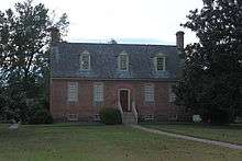
| 1 |
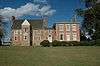
Bacon's Castle |
|
000000001966-10-15-0000October 15, 1966
(#66000849) |
Off VA 10
37°06′39″N 76°43′12″W / 37.110833°N 76.72°W / 37.110833; -76.72 (Bacon's Castle) |
Bacon's Castle |
|
| 2 |
Cedar Ridge |
Upload image |
000000002000-08-02-0000August 2, 2000
(#00000894) |
4861 Laurel Dr.
37°06′40″N 77°06′46″W / 37.111111°N 77.112778°W / 37.111111; -77.112778 (Cedar Ridge) |
Disputanta |
|
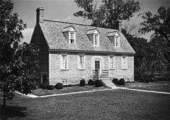
| 3 |
Chippokes Plantation |
|
000000001969-10-01-0000October 1, 1969
(#69000283) |
Chippokes State Park, Virginia 634 and 633
37°08′11″N 76°43′38″W / 37.136389°N 76.727222°W / 37.136389; -76.727222 (Chippokes Plantation) |
Jamestown |
|
| 4 |
Enos House |
Upload image |
000000001977-12-07-0000December 7, 1977
(#77001494) |
Enos Farm Drive
37°07′32″N 76°50′56″W / 37.125509°N 76.848961°W / 37.125509; -76.848961 (Enos House) |
Surry |
|
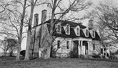
| 5 |
Four Mile Tree |
|
000000001970-12-18-0000December 18, 1970
(#70000826) |
NE of the jct. of VA 618 and VA 610
37°12′02″N 76°51′21″W / 37.200556°N 76.855833°W / 37.200556; -76.855833 (Four Mile Tree) |
Surry |
|
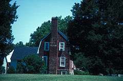
| 6 |
Glebe House of Southwark Parish |
|
000000001976-05-17-0000May 17, 1976
(#76002123) |
E of Spring Grove on VA 10
37°08′27″N 76°54′17″W / 37.140833°N 76.904722°W / 37.140833; -76.904722 (Glebe House of Southwark Parish) |
Spring Grove |
|
| 7 |
Melville |
|
000000001980-05-06-0000May 6, 1980
(#80004228) |
E of Surry
37°08′31″N 76°47′24″W / 37.141944°N 76.79°W / 37.141944; -76.79 (Melville) |
Surry |
|
| 8 |
Montpelier |
Upload image |
000000001980-03-26-0000March 26, 1980
(#80004227) |
1.4 mi. SW of Cabin Point
37°10′19″N 77°03′09″W / 37.171944°N 77.0525°W / 37.171944; -77.0525 (Montpelier) |
Cabin Point |
|
| 9 |
Old Brick Church |
|
000000001986-01-02-0000January 2, 1986
(#86000002) |
VA 10
37°06′30″N 76°44′09″W / 37.108333°N 76.735833°W / 37.108333; -76.735833 (Old Brick Church) |
Bacon's Castle |
|
| 10 |
Pleasant Point |
|
000000001976-07-16-0000July 16, 1976
(#76002122) |
1 mi. S of Scotland on VA 637
37°10′25″N 76°46′32″W / 37.173611°N 76.775556°W / 37.173611; -76.775556 (Pleasant Point) |
Scotland |
|
| 11 |
Rich Neck Farm |
Upload image |
000000001980-05-19-0000May 19, 1980
(#80004229) |
E of Surry
37°07′33″N 76°45′05″W / 37.125833°N 76.751389°W / 37.125833; -76.751389 (Rich Neck Farm) |
Surry |
|
| 12 |
Rogers' Store |
Upload image |
000000002002-05-30-0000May 30, 2002
(#02000595) |
Jct. of VA 615 and VA 612
37°05′44″N 77°00′15″W / 37.095556°N 77.004167°W / 37.095556; -77.004167 (Rogers' Store) |
Surry |
|
| 13 |
Second Southwark Church Archeological Site (44SY65) |
Upload image |
000000001984-02-23-0000February 23, 1984
(#84003610) |
Near the junction of Virginia Routes 10 and 618
37°08′00″N 76°53′10″W / 37.13345°N 76.886°W / 37.13345; -76.886 (Second Southwark Church Archeological Site (44SY65)) |
Surry |
|
| 14 |
Smith's Fort |
|
000000001970-06-15-0000June 15, 1970
(#70000827) |
Smith Fort Lane
37°09′50″N 76°49′12″W / 37.1638°N 76.82°W / 37.1638; -76.82 (Smith's Fort) |
Surry |
|
| 15 |
Snow Hill |
|
000000001979-12-28-0000December 28, 1979
(#79003091) |
VA 40
37°05′19″N 77°02′58″W / 37.088611°N 77.049444°W / 37.088611; -77.049444 (Snow Hill) |
Gwaltney Corner |
|
| 16 |
Surry County Courthouse Complex |
|
000000001986-04-10-0000April 10, 1986
(#86000719) |
VA 10
37°08′14″N 76°50′07″W / 37.137222°N 76.835278°W / 37.137222; -76.835278 (Surry County Courthouse Complex) |
Surry |
|
| 17 |
Swann's Point Plantation Site |
Upload image |
000000001975-04-01-0000April 1, 1975
(#75002040) |
Address Restricted
|
Scotland |
|
| 18 |
Walnut Valley |
Upload image |
000000002013-08-27-0000August 27, 2013
(#13000649) |
Southeastern corner of Highgate and Chippokes Farm Rds.[6]:5
37°07′15″N 76°44′33″W / 37.120833°N 76.742500°W / 37.120833; -76.742500 (Walnut Valley) |
Highgate |
Includes an archaeological site surrounding a rare surviving slave house[6]:18
|
| 19 |
Warren House |
|
000000001973-11-14-0000November 14, 1973
(#73002065) |
NE of Surry off VA 31
37°09′44″N 76°49′22″W / 37.162222°N 76.822778°W / 37.162222; -76.822778 (Warren House) |
Surry |
|
See also
References
- ↑ The latitude and longitude information provided in this table was derived originally from the National Register Information System, which has been found to be fairly accurate for about 99% of listings. For about 1% of NRIS original coordinates, experience has shown that one or both coordinates are typos or otherwise extremely far off; some corrections may have been made. A more subtle problem causes many locations to be off by up to 150 yards, depending on location in the country: most NRIS coordinates were derived from tracing out latitude and longitudes off of USGS topographical quadrant maps created under the North American Datum of 1927, which differs from the current, highly accurate WGS84 GPS system used by most on-line maps. Chicago is about right, but NRIS longitudes in Washington are higher by about 4.5 seconds, and are lower by about 2.0 seconds in Maine. Latitudes differ by about 1.0 second in Florida. Some locations in this table may have been corrected to current GPS standards.
- ↑ "National Register of Historic Places: Weekly List Actions". National Park Service, United States Department of the Interior. Retrieved on December 2, 2016.
- ↑ Numbers represent an ordering by significant words. Various colorings, defined here, differentiate National Historic Landmarks and historic districts from other NRHP buildings, structures, sites or objects.
- ↑ National Park Service (2008-04-24). "National Register Information System". National Register of Historic Places. National Park Service.
- ↑ The eight-digit number below each date is the number assigned to each location in the National Register Information System database, which can be viewed by clicking the number.
- 1 2 Cached version of National Register of Historic Places Inventory/Nomination: Walnut Valley. National Park Service, n.d.
|
|---|
|
Lists
by county | | |
|---|
|
Lists
by city | |
|---|
|
| Other lists | |
|---|
|
|
_(2).jpg)
.JPG)
_2014.JPG)
.jpg)