| [3] |
Name on the Register[4] |
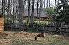
Image |
Date listed[5] |
Location |
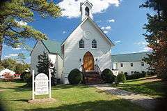
City or town |
Description |
|---|
| 1 |
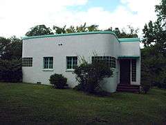
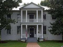
Azurest South |
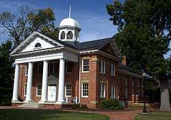
|
000000001993-12-30-0000December 30, 1993
(#93001464) |
2900 Boisseau St.
37°14′24″N 77°25′09″W / 37.24°N 77.419167°W / 37.24; -77.419167 (Azurest South) |
Petersburg |
|
| 2 |
Beach Station |
|
000000002008-02-22-0000February 22, 2008
(#08000067) |
11410 and 11400 Beach Rd.
37°21′20″N 77°35′42″W / 37.355556°N 77.595°W / 37.355556; -77.595 (Beach Station) |
Chesterfield |
Boundaries decreased on 000000002010-03-24-0000March 24, 2010
|
| 3 |
Bellona Arsenal |
|
000000001971-05-06-0000May 6, 1971
(#71000975) |
Off VA 673, northwest of the junction with VA 147
37°33′13″N 77°37′02″W / 37.553611°N 77.617222°W / 37.553611; -77.617222 (Bellona Arsenal) |
Midlothian |
|
| 4 |
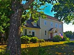
Bellwood |
Upload image |
000000001978-12-12-0000December 12, 1978
(#78003013) |
8000 Jefferson Davis Highway
37°24′55″N 77°26′10″W / 37.415159°N 77.436038°W / 37.415159; -77.436038 (Bellwood) |
Richmond |
Plantation house originally known as Sheffields and later as Auburn Chase.[6] Boundary increase on August 1, 2013.
|
| 5 |
Bethel Baptist Church |
|
000000001999-02-22-0000February 22, 1999
(#99000141) |
1100 Huguenot Springs Rd.
37°30′43″N 77°42′41″W / 37.511944°N 77.711389°W / 37.511944; -77.711389 (Bethel Baptist Church) |
Midlothian |
|
| 6 |
Bon Air Historic District |
|
000000001988-11-15-0000November 15, 1988
(#88002178) |
Roughly bounded by Forest Hill Rd., N. Robert, W. Bon View Dr., and McRae Rd.
37°31′34″N 77°33′26″W / 37.526111°N 77.557222°W / 37.526111; -77.557222 (Bon Air Historic District) |
Richmond |
|
| 7 |
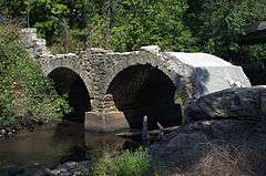
Bridge at Falling Creek |
|
000000001995-10-12-0000October 12, 1995
(#95001171) |
US 1/301 at Falling Cr.
37°26′22″N 77°26′22″W / 37.439444°N 77.439444°W / 37.439444; -77.439444 (Bridge at Falling Creek) |
Richmond |
|
| 8 |
Castlewood |
|
000000001976-11-21-0000November 21, 1976
(#76002099) |
VA 10
37°22′31″N 77°30′11″W / 37.375278°N 77.503056°W / 37.375278; -77.503056 (Castlewood) |
Chesterfield |
|
| 9 |
Chester Presbyterian Church |
|
000000001976-11-21-0000November 21, 1976
(#76002098) |
Junction of Osborne Rd. and VA 10
37°21′33″N 77°25′53″W / 37.359167°N 77.431389°W / 37.359167; -77.431389 (Chester Presbyterian Church) |
Chester |
|
| 10 |
Chesterfield County Courthouse and Courthouse Square |
|
000000001992-08-18-0000August 18, 1992
(#92001008) |
North side VA 10, 350 feet (110 m) east of the junction with VA 655
37°22′35″N 77°30′26″W / 37.376389°N 77.507222°W / 37.376389; -77.507222 (Chesterfield County Courthouse and Courthouse Square) |
Chesterfield |
Chesterfield Historic Courthouse at Courthouse Square
|
| 11 |
Dale's Pale Archeological District |
Upload image |
000000002007-01-19-0000January 19, 2007
(#06001012) |
South shore of James R., Chesterfield County Park
Coordinates missing |
Chester |
|
| 12 |
Dinwiddie County Pullman Car |
Upload image |
000000001991-07-03-0000July 3, 1991
(#91000834) |
Hallsboro Yard, northeast of the junction of VA 606 and VA 671
37°28′59″N 77°44′10″W / 37.483056°N 77.736111°W / 37.483056; -77.736111 (Dinwiddie County Pullman Car) |
Midlothian |
|
| 13 |
Eppington |
Upload image |
000000001969-11-12-0000November 12, 1969
(#69000230) |
South of the junction of VA 621 and 602
37°18′04″N 77°42′27″W / 37.301111°N 77.7075°W / 37.301111; -77.7075 (Eppington) |
Winterpock |
|
| 14 |
Falling Creek Ironworks Archeological Site |
Upload image |
000000001995-03-29-0000March 29, 1995
(#95000242) |
Address Restricted
37°26′19″N 77°26′19″W / 37.438611°N 77.438611°W / 37.438611; -77.438611 (Falling Creek Ironworks Archeological Site) |
Richmond |
|
| 15 |
Falling Creek UDC Jefferson Davis Highway Marker |
|
000000002013-01-23-0000January 23, 2013
(#12001220) |
US 1 at Falling Creek Wayside
37°26′21″N 77°26′21″W / 37.439207°N 77.439103°W / 37.439207; -77.439103 (Falling Creek UDC Jefferson Davis Highway Marker) |
Richmond |
|
| 16 |
Hallsboro Store |
|
000000002005-03-10-0000March 10, 2005
(#05000133) |
920 Hallsboro Rd.
37°29′26″N 77°43′35″W / 37.490556°N 77.726389°W / 37.490556; -77.726389 (Hallsboro Store) |
Midlothian |
|
| 17 |
Hallsborough Tavern |
|
000000001980-03-17-0000March 17, 1980
(#80004181) |
West of Midlothian on US 60
37°30′31″N 77°42′40″W / 37.508611°N 77.711111°W / 37.508611; -77.711111 (Hallsborough Tavern) |
Midlothian |
|
| 18 |
Henrico |
|
000000001972-04-13-0000April 13, 1972
(#72001400) |
251 Henricus Park Road[7]
37°22′31″N 77°21′41″W / 37.3753°N 77.3613°W / 37.3753; -77.3613 (Henrico) |
Dutch Gap |
|
| 19 |
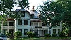
Keswick |
|
000000001974-12-19-0000December 19, 1974
(#74002144) |
Northeast of Powhatan off VA 711
37°33′39″N 77°39′52″W / 37.560833°N 77.664444°W / 37.560833; -77.664444 (Keswick) |
Powhatan |
Also listed in the NRHP NRIS database in Powhatan, Virginia
|
| 20 |
Kingsland |
Upload image |
000000001975-09-18-0000September 18, 1975
(#75002019) |
1608 Willis Rd.
37°24′14″N 77°24′48″W / 37.403889°N 77.413333°W / 37.403889; -77.413333 (Kingsland) |
Chimney Corner |
|
| 21 |
Magnolia Grange |
|
000000001980-03-17-0000March 17, 1980
(#80004179) |
VA 10
37°22′30″N 77°30′27″W / 37.375°N 77.5075°W / 37.375; -77.5075 (Magnolia Grange) |
Chesterfield |
|
| 22 |
Olive Hill |
Upload image |
000000001975-04-03-0000April 3, 1975
(#75002017) |
0.5 miles (0.80 km) west of Matoaca off VA 36
37°13′34″N 77°29′48″W / 37.226111°N 77.496667°W / 37.226111; -77.496667 (Olive Hill) |
Matoaca |
|
| 23 |
Pleasant View |
|
000000001975-06-10-0000June 10, 1975
(#75002018) |
1.5 miles (2.4 km) east of Midlothian on VA 677
37°30′42″N 77°37′18″W / 37.511667°N 77.621667°W / 37.511667; -77.621667 (Pleasant View) |
Midlothian |
|
| 24 |
Pocahontas State Park Historic District |
|
000000002016-02-08-0000February 8, 2016
(#15001054) |
10301 State Park Rd.
37°23′12″N 77°34′49″W / 37.386737°N 77.580175°W / 37.386737; -77.580175 (Pocahontas State Park Historic District) |
Chesterfield |
|
| 25 |
Point of Rocks |
Upload image |
000000002005-03-10-0000March 10, 2005
(#05000134) |
1005 Point of Rocks Rd.
37°19′18″N 77°20′17″W / 37.321667°N 77.338056°W / 37.321667; -77.338056 (Point of Rocks) |
Chester |
|
| 26 |
Proctor Creek, Jefferson Davis Highway Marker |
Upload image |
000000002008-09-12-0000September 12, 2008
(#08000892) |
9300 Block of Jefferson Davis Hwy.
37°23′50″N 77°25′53″W / 37.397303°N 77.431303°W / 37.397303; -77.431303 (Proctor Creek, Jefferson Davis Highway Marker) |
Richmond |
|
| 27 |
Swift Creek Mill |
|
000000001974-01-11-0000January 11, 1974
(#74002113) |
North of Colonial Heights on U.S. 1
37°17′00″N 77°24′42″W / 37.283333°N 77.411667°W / 37.283333; -77.411667 (Swift Creek Mill) |
Colonial Heights |
|
| 28 |
Town of Bermuda Hundred Historic District |
Upload image |
000000002006-11-08-0000November 8, 2006
(#06001011) |
Both sides of Bermuda Hundred and Allied Rds.
37°20′33″N 77°16′22″W / 37.3425°N 77.272778°W / 37.3425; -77.272778 (Town of Bermuda Hundred Historic District) |
Chester |
|
| 29 |
Vawter Hall and Old President's House |
Upload image |
000000001980-05-07-0000May 7, 1980
(#80004180) |
Virginia State University campus
37°14′04″N 77°25′05″W / 37.234444°N 77.418056°W / 37.234444; -77.418056 (Vawter Hall and Old President's House) |
Ettrick |
|
.JPG)
.jpg)


%2C_State_Route_711_vicinity%2C_Huguenot_vicinity_(Powhatan_County%2C_Virginia).jpg)
.jpg)


