| [3] |
Name on the Register[4] |
Image |
Date listed[5] |
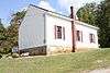
Location |
City or town |
Description |
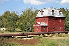
|---|
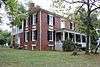
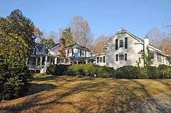
| 1 |
Avenel |
|
000000001992-01-30-0000January 30, 1992
(#92000003) |
413 Avenel Ave.
37°20′16″N 79°31′29″W / 37.337778°N 79.524722°W / 37.337778; -79.524722 (Avenel) |
Bedford |
|
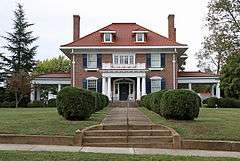
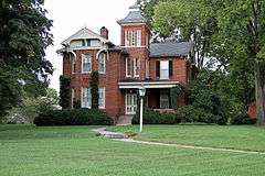
| 2 |
John D. Ballard House |
|
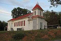
000000001997-12-12-0000December 12, 1997
(#97001505) |
525 Longwood Ave.
37°20′21″N 79°31′13″W / 37.339167°N 79.520278°W / 37.339167; -79.520278 (John D. Ballard House) |
Bedford |
|
| 3 |
Bedford Historic District |
|
000000001984-10-04-0000October 4, 1984
(#84000031) |
Roughly bounded by Longwood, Bedford, and Mountain Aves., Peaks, Oak, Grove, and Washington Sts.
37°20′15″N 79°31′21″W / 37.3375°N 79.5225°W / 37.3375; -79.5225 (Bedford Historic District) |
Bedford |
|
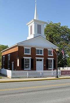
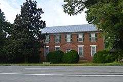
| 4 |
Bedford Historic Meetinghouse |
|
000000001978-01-31-0000January 31, 1978
(#78003182) |
153 W. Main St.
37°20′05″N 79°31′32″W / 37.334722°N 79.525556°W / 37.334722; -79.525556 (Bedford Historic Meetinghouse) |
Bedford |
|
| 5 |
Bellevue |
Upload image |
000000001990-12-19-0000December 19, 1990
(#89001917) |
VA 643, 1 mi. E of Goode
37°21′51″N 79°22′09″W / 37.364167°N 79.369167°W / 37.364167; -79.369167 (Bellevue) |
Goode |
|
| 6 |
Bellevue Rural Historic District |
Upload image |
000000002005-11-30-0000November 30, 2005
(#05001345) |
Bellevue Rd.
37°21′55″N 79°22′19″W / 37.365278°N 79.371944°W / 37.365278; -79.371944 (Bellevue Rural Historic District) |
Forest |
|
| 7 |
Big Otter Mill |
|
000000001998-10-30-0000October 30, 1998
(#98001314) |
VA 122
37°23′27″N 79°30′14″W / 37.390833°N 79.503889°W / 37.390833; -79.503889 (Big Otter Mill) |
Bedford |
|
| 8 |
Brook Hill Farm |
Upload image |
000000001997-06-06-0000June 6, 1997
(#97000489) |
0.75 mi. S of jct. of US 221 and VA 643
37°22′07″N 79°22′17″W / 37.368611°N 79.371389°W / 37.368611; -79.371389 (Brook Hill Farm) |
Forest |
|
| 9 |
Burks-Guy-Hagen House |
|
000000001985-12-19-0000December 19, 1985
(#85003201) |
520 Peaks St.
37°20′18″N 79°31′20″W / 37.338364°N 79.522114°W / 37.338364; -79.522114 (Burks-Guy-Hagen House) |
Bedford |
|
| 10 |
Cifax Rural Historic District |
Upload image |
000000001992-02-20-0000February 20, 1992
(#92000052) |
Jct. of VA 644 and VA 643 and surrounding valley area
37°25′02″N 79°24′32″W / 37.417222°N 79.408889°W / 37.417222; -79.408889 (Cifax Rural Historic District) |
Cifax |
|
| 11 |
Bowling Eldridge House |
Upload image |
000000001993-08-12-0000August 12, 1993
(#93000824) |
1651 Fox Hill Rd.
37°28′22″N 79°12′03″W / 37.472795°N 79.200972°W / 37.472795; -79.200972 (Bowling Eldridge House) |
Lynchburg |
|
| 12 |
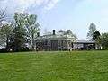
Elk Hill |
Upload image |
000000001973-04-02-0000April 2, 1973
(#73001996) |
NW of Forest on VA 663
37°24′25″N 79°20′57″W / 37.406944°N 79.349167°W / 37.406944; -79.349167 (Elk Hill) |
Forest |
|
| 13 |
Elks National Home |
|
000000002008-05-29-0000May 29, 2008
(#08000479) |
931 Ashland Ave.
37°20′37″N 79°32′15″W / 37.3434782°N 79.5373849°W / 37.3434782; -79.5373849 (Elks National Home) |
Bedford |
|
| 14 |
Fancy Farm |
|
000000001972-01-07-0000January 7, 1972
(#72001384) |
On VA 43, N of jct. with VA 682
37°23′53″N 79°33′24″W / 37.398056°N 79.556667°W / 37.398056; -79.556667 (Fancy Farm) |
Bedford |
|
| 15 |
Hope Dawn |
Upload image |
000000001974-10-09-0000October 9, 1974
(#74002106) |
NW of Lynchburg off VA 761
37°30′00″N 79°13′53″W / 37.5°N 79.231389°W / 37.5; -79.231389 (Hope Dawn) |
Lynchburg |
|
| 16 |
Liberty Hall |
Upload image |
000000002009-08-12-0000August 12, 2009
(#09000613) |
12000 E. Lynchburg Salem Turnpike
37°18′22″N 79°18′49″W / 37.306111°N 79.313611°W / 37.306111; -79.313611 (Liberty Hall) |
Forest |
|
| 17 |
Locust Level |
|
000000001990-12-21-0000December 21, 1990
(#90001841) |
US 460 W of jct. with VA 695
37°23′11″N 79°44′14″W / 37.386389°N 79.737222°W / 37.386389; -79.737222 (Locust Level) |
Montvale |
|
| 18 |
Mount Airy |
Upload image |
000000001990-12-19-0000December 19, 1990
(#90001823) |
Jct. of VA 630 and VA 631
37°06′19″N 79°25′01″W / 37.105278°N 79.416944°W / 37.105278; -79.416944 (Mount Airy) |
Leesville |
|
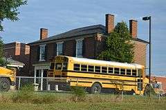
| 19 |
New London Academy |
|
000000001972-04-13-0000April 13, 1972
(#72001385) |
Near jct. of VA 297 and VA 211
37°18′24″N 79°18′19″W / 37.306528°N 79.305278°W / 37.306528; -79.305278 (New London Academy) |
Forest |
|
| 20 |
New Prospect Church |
|
000000002000-03-31-0000March 31, 2000
(#00000312) |
4445 Sheep Creek Rd.
37°25′35″N 79°32′44″W / 37.426389°N 79.545556°W / 37.426389; -79.545556 (New Prospect Church) |
Bedford |
|
| 21 |
Old Rectory |
Upload image |
000000001973-07-24-0000July 24, 1973
(#73001998) |
S of Perrowville on VA 663
37°24′09″N 79°20′15″W / 37.4025°N 79.3375°W / 37.4025; -79.3375 (Old Rectory) |
Perrowville |
|
| 22 |
Olive Branch Missionary Baptist Church |
|
000000002007-05-04-0000May 4, 2007
(#07000392) |
5982 Joppa Mill Rd.
37°14′54″N 79°37′34″W / 37.248333°N 79.626111°W / 37.248333; -79.626111 (Olive Branch Missionary Baptist Church) |
Moneta |
|
| 23 |
Otterburn |
Upload image |
000000002001-02-16-0000February 16, 2001
(#01000146) |
Big Island Rd.
37°22′05″N 79°29′50″W / 37.368056°N 79.497222°W / 37.368056; -79.497222 (Otterburn) |
Bedford |
|
| 24 |
Pleasant View |
Upload image |
000000002006-11-15-0000November 15, 2006
(#06001043) |
5050 Bellevue Rd.
37°20′53″N 79°21′46″W / 37.348056°N 79.362778°W / 37.348056; -79.362778 (Pleasant View) |
Forest |
|
| 25 |
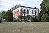
Poplar Forest |
|
000000001969-11-12-0000November 12, 1969
(#69000223) |
S of jct. of Rtes. 661 and 460
37°20′50″N 79°16′15″W / 37.347222°N 79.270833°W / 37.347222; -79.270833 (Poplar Forest) |
Lynchburg |
|
| 26 |
Rothsay |
Upload image |
000000001992-10-30-0000October 30, 1992
(#92001387) |
US 221 N side, 2000 ft. E of jct. with VA 811
37°21′58″N 79°17′11″W / 37.366111°N 79.286389°W / 37.366111; -79.286389 (Rothsay) |
Forest |
|
| 27 |
Saint Stephen's Episcopal Church |
Upload image |
000000001985-11-07-0000November 7, 1985
(#85002766) |
VA 663
37°22′40″N 79°18′30″W / 37.377778°N 79.308333°W / 37.377778; -79.308333 (Saint Stephen's Episcopal Church) |
Forest |
|
| 28 |
Thomas Methodist Episcopal Chapel |
Upload image |
000000002004-08-11-0000August 11, 2004
(#04000844) |
VA 684, Penicks Mill Rd.
37°22′50″N 79°37′38″W / 37.380556°N 79.627222°W / 37.380556; -79.627222 (Thomas Methodist Episcopal Chapel) |
Thaxton |
|
| 29 |
Three Otters |
|
000000001970-09-15-0000September 15, 1970
(#70000785) |
W of jct. of Rte. 838 and VA 43
37°21′22″N 79°32′46″W / 37.356111°N 79.546111°W / 37.356111; -79.546111 (Three Otters) |
Bedford |
|
| 30 |
Twin Oaks Farm |
|
000000002001-07-05-0000July 5, 2001
(#01000704) |
VA 2
37°25′44″N 79°37′54″W / 37.428889°N 79.631667°W / 37.428889; -79.631667 (Twin Oaks Farm) |
Bedford County |
|
| 31 |
Woodbourne |
Upload image |
000000001973-07-02-0000July 2, 1973
(#73001997) |
NE of Forest off VA 609
37°22′15″N 79°16′37″W / 37.370833°N 79.276944°W / 37.370833; -79.276944 (Woodbourne) |
Forest |
|