| [3] |
Name on the Register[4] |
Image |
Date listed[5] |
Location |
City or town |
Description |
|---|
| 1 |
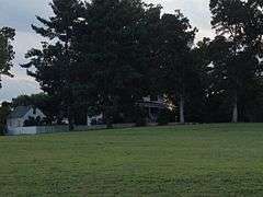
Ashland Historic District |
|
000000001983-02-11-0000February 11, 1983
(#83003284) |
Center, Racecourse, James, Howard, Clay Sts., Hanover and Railroad Aves.
37°45′29″N 77°28′56″W / 37.758056°N 77.482222°W / 37.758056; -77.482222 (Ashland Historic District) |
Ashland |
|
| 2 |
Ashland UDC Jefferson Davis Highway Marker |
|
000000002013-08-27-0000August 27, 2013
(#13000642) |
Junction of Cedar Lane and the Washington Highway
37°41′22″N 77°27′45″W / 37.689356°N 77.46254°W / 37.689356; -77.46254 (Ashland UDC Jefferson Davis Highway Marker) |
Glen Allen |
UDC Commemorative Highway Markers along the Jefferson Davis Highway in Virginia
|
| 3 |
Beaverdam Depot |
|
000000001988-11-08-0000November 8, 1988
(#88002060) |
On C & O RR tracks at jct. of VA 715 and 739
37°56′27″N 77°39′15″W / 37.940833°N 77.654167°W / 37.940833; -77.654167 (Beaverdam Depot) |
Beaverdam |
|
| 4 |
Church Quarter |
|
000000002000-11-22-0000November 22, 2000
(#00001436) |
12432 Old Ridge Rd.
37°50′52″N 77°31′27″W / 37.847778°N 77.524167°W / 37.847778; -77.524167 (Church Quarter) |
Doswell |
|
| 5 |
Clover Lea |
Upload image |
000000001979-02-28-0000February 28, 1979
(#79003045) |
E of Mechanicsville off VA 629
37°38′36″N 77°11′07″W / 37.643333°N 77.185278°W / 37.643333; -77.185278 (Clover Lea) |
Mechanicsville |
|
| 6 |
Cold Harbor National Cemetery |
|
000000001995-08-10-0000August 10, 1995
(#95000922) |
Jct. VA 156 and 619, .5 mi. E
37°38′36″N 77°16′55″W / 37.643333°N 77.281944°W / 37.643333; -77.281944 (Cold Harbor National Cemetery) |
Mechanicsville |
|
| 7 |
Cool Well |
|
000000002007-09-06-0000September 6, 2007
(#07000931) |
8198 Shady Grove Rd,
37°37′36″N 77°22′35″W / 37.626667°N 77.376389°W / 37.626667; -77.376389 (Cool Well) |
Mechanicsville |
|
| 8 |
Dewberry |
|
000000001996-05-23-0000May 23, 1996
(#96000576) |
Approximately 1 mi. NE of jct. of VA 738 and VA 601
37°53′47″N 77°35′24″W / 37.896389°N 77.59°W / 37.896389; -77.59 (Dewberry) |
Beaverdam |
|
| 9 |
Fork Church |
|
000000001970-02-26-0000February 26, 1970
(#70000801) |
At jct. of Rtes. 738 and 685
37°51′13″N 77°31′54″W / 37.853611°N 77.531667°W / 37.853611; -77.531667 (Fork Church) |
Ashland |
|
| 10 |
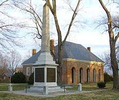
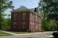
Hanover County Courthouse |
|
000000001969-10-01-0000October 1, 1969
(#69000247) |
Jct. of Rte. 1006 and U.S. 301
37°45′47″N 77°22′03″W / 37.763056°N 77.3675°W / 37.763056; -77.3675 (Hanover County Courthouse) |
Hanover Court House |
|
| 11 |
Hanover County Courthouse Historic District |
|
000000001971-09-22-0000September 22, 1971
(#71000980) |
US 301
37°45′43″N 77°22′01″W / 37.761944°N 77.366944°W / 37.761944; -77.366944 (Hanover County Courthouse Historic District) |
Hanover |
|
| 12 |
Hanover Meeting House |
|
000000001991-09-04-0000September 4, 1991
(#91001089) |
6411 Heatherwood Drive[6]
37°38′43″N 77°19′49″W / 37.645398°N 77.33041°W / 37.645398; -77.33041 (Hanover Meeting House) |
Mechanicsville |
Site of the first non-Anglican church in Virginia
|
| 13 |
Hanover Town |
Upload image |
000000001974-09-17-0000September 17, 1974
(#74002122) |
Address Restricted
|
Mechanicsville |
|
| 14 |
Hanover Wayside |
|
000000002002-11-22-0000November 22, 2002
(#02001365) |
8225 Hanover Wayside Rd.
37°42′01″N 77°23′12″W / 37.700278°N 77.386667°W / 37.700278; -77.386667 (Hanover Wayside) |
Hanover |
|
| 15 |
Hickory Hill |
Upload image |
000000001974-11-21-0000November 21, 1974
(#74002121) |
E of Ashland off VA 646
37°46′28″N 77°24′47″W / 37.774444°N 77.413056°W / 37.774444; -77.413056 (Hickory Hill) |
Ashland |
|
| 16 |
Immanuel Episcopal Church |
Upload image |
000000001996-05-23-0000May 23, 1996
(#96000577) |
SR 606, 1.7 mi. E of jct. with US 360
37°38′35″N 77°12′59″W / 37.643056°N 77.216389°W / 37.643056; -77.216389 (Immanuel Episcopal Church) |
Mechanicsville |
|
| 17 |
Laurel Meadow |
Upload image |
000000001995-07-07-0000July 7, 1995
(#95000827) |
VA 643 E side, 0.2 mi. S of jct. with VA 627
37°38′00″N 77°20′14″W / 37.633333°N 77.337222°W / 37.633333; -77.337222 (Laurel Meadow) |
Mechanicsville |
|
| 18 |
Montpelier Historic District |
Upload image |
000000002002-05-16-0000May 16, 2002
(#02000517) |
Roughly along Mountain Rd.
37°49′09″N 77°41′04″W / 37.819167°N 77.684444°W / 37.819167; -77.684444 (Montpelier Historic District) |
Montpelier |
|
| 19 |
Oak Forest |
|
000000001999-08-23-0000August 23, 1999
(#99000964) |
7400 Rural Point Road
37°40′28″N 77°20′53″W / 37.674458°N 77.348078°W / 37.674458; -77.348078 (Oak Forest) |
Mechanicsville |
|
| 20 |
Oakland |
Upload image |
000000001974-07-30-0000July 30, 1974
(#74002123) |
N of Montpelier
37°52′30″N 77°39′49″W / 37.875°N 77.663611°W / 37.875; -77.663611 (Oakland) |
Montpelier |
|
| 21 |
Oakley Hill |
|
000000001994-05-19-0000May 19, 1994
(#94000459) |
VA 156 S side, 2500 ft. W of jct. with VA 643
37°35′43″N 77°20′24″W / 37.595278°N 77.34°W / 37.595278; -77.34 (Oakley Hill) |
Mechanicsville |
|
| 22 |
Patrick Henry's Birthplace Archeological Site |
Upload image |
000000001982-08-02-0000August 2, 1982
(#82001819) |
9620 Studley Farm Drive[7]
37°40′09″N 77°17′28″W / 37.669113°N 77.290977°W / 37.669113; -77.290977 (Patrick Henry's Birthplace Archeological Site) |
Studley |
|
| 23 |
Pine Slash |
Upload image |
000000001987-11-19-0000November 19, 1987
(#87001946) |
VA 643
37°39′19″N 77°19′35″W / 37.655278°N 77.326389°W / 37.655278; -77.326389 (Pine Slash) |
Studley |
|
| 24 |
Randolph-Macon College Buildings |
|
000000001979-06-19-0000June 19, 1979
(#79003044) |
Randolph-Macon College campus
37°45′38″N 77°28′47″W / 37.760556°N 77.479722°W / 37.760556; -77.479722 (Randolph-Macon College Buildings) |
Ashland |
|
| 25 |
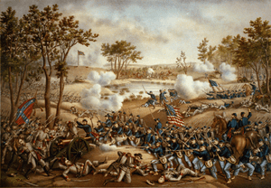
Richmond National Battlefield Park |
|
000000001966-10-15-0000October 15, 1966
(#66000836) |
E of Richmond
37°25′45″N 77°22′25″W / 37.429167°N 77.373611°W / 37.429167; -77.373611 (Richmond National Battlefield Park) |
Richmond |
|
| 26 |
Edmund Ruffin Plantation |
Upload image |
000000001966-10-15-0000October 15, 1966
(#66000837) |
11 mi. NE of Richmond on U.S. 360
37°39′50″N 77°13′08″W / 37.663889°N 77.218889°W / 37.663889; -77.218889 (Edmund Ruffin Plantation) |
Richmond |
Also known as Marlbourne
|
| 27 |
Rural Plains |
|
000000001975-06-05-0000June 5, 1975
(#75002021) |
6 mi. N of Mechanicsville off VA 606
37°39′26″N 77°20′52″W / 37.657222°N 77.347778°W / 37.657222; -77.347778 (Rural Plains) |
Mechanicsville |
|
| 28 |
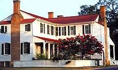
Scotchtown |
|
000000001966-10-15-0000October 15, 1966
(#66000835) |
10 mi. NW of Ashland on VA 685
37°50′36″N 77°35′08″W / 37.843333°N 77.585556°W / 37.843333; -77.585556 (Scotchtown) |
Ashland |
Also known as Patrick Henry House
|
| 29 |
Selwyn |
|
000000002003-05-22-0000May 22, 2003
(#03000445) |
6279 Powhite Farm Dr.
37°34′55″N 77°19′14″W / 37.581944°N 77.320556°W / 37.581944; -77.320556 (Selwyn) |
Mechanicsville |
|
| 30 |
Sharp's Oakland |
Upload image |
000000002002-01-24-0000January 24, 2002
(#01001514) |
12308 Verdon Rd.
37°53′56″N 77°30′49″W / 37.898889°N 77.513611°W / 37.898889; -77.513611 (Sharp's Oakland) |
Doswell |
|
| 31 |
Slash Church |
|
000000001972-09-22-0000September 22, 1972
(#72001399) |
VA 656, N of jct. with VA 657
37°43′07″N 77°24′54″W / 37.718611°N 77.415°W / 37.718611; -77.415 (Slash Church) |
Ashland |
|
| 32 |
Spring Green |
Upload image |
000000002002-12-31-0000December 31, 2002
(#02000316) |
2160 Old Church Rd.
37°37′49″N 77°10′21″W / 37.630278°N 77.1725°W / 37.630278; -77.1725 (Spring Green) |
Mechanicsville |
|
| 33 |
Springfield |
Upload image |
000000001994-08-16-0000August 16, 1994
(#94000990) |
VA 631 S side, 0.4 mi. SW of jct. with VA 671
37°51′57″N 77°36′48″W / 37.865833°N 77.613333°W / 37.865833; -77.613333 (Springfield) |
Coatesville |
|
| 34 |
St. Paul's Episcopal Church |
|
000000001994-05-19-0000May 19, 1994
(#94000460) |
Jct. of US 301 and VA 54, SW corner
37°46′04″N 77°22′15″W / 37.767662°N 77.370872°W / 37.767662; -77.370872 (St. Paul's Episcopal Church) |
Hanover |
|
| 35 |
Sycamore Tavern |
|
000000001974-07-24-0000July 24, 1974
(#74002124) |
W of U.S. 33
37°49′21″N 77°41′15″W / 37.8225°N 77.6875°W / 37.8225; -77.6875 (Sycamore Tavern) |
Montpelier |
|
| 36 |
The Tavern at Old Church |
Upload image |
000000002016-05-16-0000May 16, 2016
(#16000260) |
3350-3360 Old Church Rd.
37°38′40″N 77°13′17″W / 37.644550°N 77.221383°W / 37.644550; -77.221383 (The Tavern at Old Church) |
Mechanicsville |
|
| 37 |
Totomoi |
Upload image |
000000001976-12-12-0000December 12, 1976
(#76002108) |
W of Studley on VA 643
37°40′14″N 77°22′01″W / 37.670556°N 77.366944°W / 37.670556; -77.366944 (Totomoi) |
Studley |
|
| 38 |
Trinity Church |
Upload image |
000000001990-12-27-0000December 27, 1990
(#90001923) |
Jct. of VA 738 and VA 658
37°54′03″N 77°38′37″W / 37.900833°N 77.643611°W / 37.900833; -77.643611 (Trinity Church) |
Beaverdam |
|
| 39 |
Virginia Industrial Home School for Colored Girls |
Upload image |
000000002016-10-07-0000October 7, 2016
(#15000926) |
11391 Barrett Center Rd.
37°42′39″N 77°21′42″W / 37.710947°N 77.361564°W / 37.710947; -77.361564 (Virginia Industrial Home School for Colored Girls) |
Mechanicsville |
|
| 40 |
Williamsville |
Upload image |
000000001985-11-18-0000November 18, 1985
(#85002915) |
Off VA 615
37°41′47″N 77°18′27″W / 37.696389°N 77.3075°W / 37.696389; -77.3075 (Williamsville) |
Studley |
|
_Station-Visitor's_Center.JPG)
.jpg)
.jpg)

.jpg)

%2C_Richmond_National_Battlefield_Park_(Hanover_County%2C_Virginia).jpg)
.jpg)
_-_front.JPG)


