National Register of Historic Places listings in Cumberland County, Virginia

Location of Cumberland County in Virginia
This is a list of the National Register of Historic Places listings in Cumberland County, Virginia.
This is intended to be a complete list of the properties and districts on the National Register of Historic Places in Cumberland County, Virginia, United States. The locations of National Register properties and districts for which the latitude and longitude coordinates are included below, may be seen in a Google map.[1]
There are 16 properties and districts listed on the National Register in the county.
- This National Park Service list is complete through NPS recent listings posted December 2, 2016.[2]
Current listings
| [3] |
Name on the Register[4] |
Image |
Date listed[5] |
Location |
City or town |
Description |
|---|
| 1 |
Ampthill |
Upload image |
000000001972-04-13-0000April 13, 1972
(#72001389) |
West side of VA 602, 3 miles (4.8 km) north of the junction with VA 45
37°41′34″N 78°06′13″W / 37.692778°N 78.103611°W / 37.692778; -78.103611 (Ampthill) |
Cartersville |
|
| 2 |
Bear Creek Lake State Park |
|
000000002012-10-31-0000October 31, 2012
(#12000904) |
22 Bear Creek Lake Rd.
37°31′45″N 78°16′19″W / 37.529128°N 78.271818°W / 37.529128; -78.271818 (Bear Creek Lake State Park) |
Cumberland |
|
| 3 |
Cartersville Bridge |
Upload image |
000000001972-09-14-0000September 14, 1972
(#72001390) |
VA 45 over James River
37°40′12″N 78°05′14″W / 37.67°N 78.087222°W / 37.67; -78.087222 (Cartersville Bridge) |
Cartersville |
|
| 4 |
Cartersville Historic District |
Upload image |
000000001993-06-10-0000June 10, 1993
(#93000505) |
Roughly bounded by VA 45, Virginia 649 and VA 656
37°40′01″N 78°05′24″W / 37.666944°N 78.09°W / 37.666944; -78.09 (Cartersville Historic District) |
Cartersville |
|
| 5 |
Clifton |
Upload image |
000000001973-06-19-0000June 19, 1973
(#73002007) |
North of Hamilton off VA 690
37°40′24″N 78°07′51″W / 37.673333°N 78.130833°W / 37.673333; -78.130833 (Clifton) |
Hamilton |
|
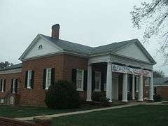
| 6 |
Cumberland County Courthouse |
|
000000001994-09-30-0000September 30, 1994
(#94001178) |
US 60, north side, at the junction with SR 600
37°29′55″N 78°14′41″W / 37.498611°N 78.244722°W / 37.498611; -78.244722 (Cumberland County Courthouse) |
Cumberland |
|
| 7 |
Cumberland Court House Historic District |
|
000000002007-08-16-0000August 16, 2007
(#07000829) |
VA 60, junction of VA 600
37°29′55″N 78°14′41″W / 37.498611°N 78.244722°W / 37.498611; -78.244722 (Cumberland Court House Historic District) |
Cumberland |
|
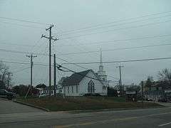
| 8 |
Grace Church |
|
000000001980-10-30-0000October 30, 1980
(#80004185) |
West of Cumberland on VA 632
37°29′00″N 78°19′44″W / 37.483333°N 78.328889°W / 37.483333; -78.328889 (Grace Church) |
Ca Ira |
|
| 9 |
Hamilton High School |
Upload image |
000000002007-10-31-0000October 31, 2007
(#07001136) |
1925 Cartersville Rd.
37°39′30″N 78°07′39″W / 37.658333°N 78.1275°W / 37.658333; -78.1275 (Hamilton High School) |
Cartersville |
|
| 10 |
High Bridge |
|
000000002008-09-12-0000September 12, 2008
(#08000875) |
Appomattox River
37°18′40″N 78°19′06″W / 37.310978°N 78.318261°W / 37.310978; -78.318261 (High Bridge) |
Farmville |
Extends into Prince Edward County
|
| 11 |
Morven |
Upload image |
000000001990-12-28-0000December 28, 1990
(#90002014) |
VA 45, 0.5 miles (0.80 km) south of Cartersville
37°39′33″N 78°05′57″W / 37.659167°N 78.099167°W / 37.659167; -78.099167 (Morven) |
Cartersville |
|
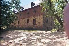
| 12 |
Muddy Creek Mill |
|
000000001974-10-09-0000October 9, 1974
(#74002114) |
South of Cartersville off VA 684
37°38′54″N 78°04′59″W / 37.648333°N 78.083056°W / 37.648333; -78.083056 (Muddy Creek Mill) |
Tamworth |
|
| 13 |
Needham |
|
000000001988-11-10-0000November 10, 1988
(#88002059) |
State Route 45, 1.4 miles (2.3 km) north of the junction with U.S. Route 460
37°19′20″N 78°23′07″W / 37.322222°N 78.385278°W / 37.322222; -78.385278 (Needham) |
Farmville |
|
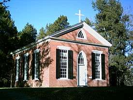
| 14 |
Oak Hill |
Upload image |
000000002005-07-27-0000July 27, 2005
(#05000764) |
181 Oak Hill Rd.
37°29′37″N 78°18′48″W / 37.493611°N 78.313333°W / 37.493611; -78.313333 (Oak Hill) |
Cumberland |
|
| 15 |
Charles Irving Thornton Tombstone |
Upload image |
000000001980-11-25-0000November 25, 1980
(#80004186) |
West of Cumberland on Oak Hill Rd.
37°29′33″N 78°18′49″W / 37.4925°N 78.313611°W / 37.4925; -78.313611 (Charles Irving Thornton Tombstone) |
Cumberland |
|
| 16 |
Trenton |
Upload image |
000000002005-07-27-0000July 27, 2005
(#05000765) |
751 Oak Hill Rd.
37°31′45″N 78°17′07″W / 37.529167°N 78.285278°W / 37.529167; -78.285278 (Trenton) |
Cumberland |
|
See also
References
- ↑ The latitude and longitude information provided in this table was derived originally from the National Register Information System, which has been found to be fairly accurate for about 99% of listings. For about 1% of NRIS original coordinates, experience has shown that one or both coordinates are typos or otherwise extremely far off; some corrections may have been made. A more subtle problem causes many locations to be off by up to 150 yards, depending on location in the country: most NRIS coordinates were derived from tracing out latitude and longitudes off of USGS topographical quadrant maps created under the North American Datum of 1927, which differs from the current, highly accurate WGS84 GPS system used by most on-line maps. Chicago is about right, but NRIS longitudes in Washington are higher by about 4.5 seconds, and are lower by about 2.0 seconds in Maine. Latitudes differ by about 1.0 second in Florida. Some locations in this table may have been corrected to current GPS standards.
- ↑ "National Register of Historic Places: Weekly List Actions". National Park Service, United States Department of the Interior. Retrieved on December 2, 2016.
- ↑ Numbers represent an ordering by significant words. Various colorings, defined here, differentiate National Historic Landmarks and historic districts from other NRHP buildings, structures, sites or objects.
- ↑ National Park Service (2008-04-24). "National Register Information System". National Register of Historic Places. National Park Service.
- ↑ The eight-digit number below each date is the number assigned to each location in the National Register Information System database, which can be viewed by clicking the number.
|
|---|
|
Lists
by county | | |
|---|
|
Lists
by city | |
|---|
|
| Other lists | |
|---|
|
|
.jpg)