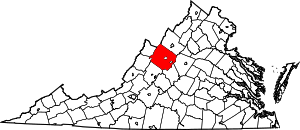
| [3] |
Name on the Register[4] |
Image |
Date listed[5] |
Location |
City or town |
Description |
|---|
| 1 |
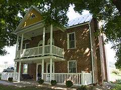
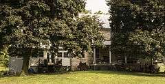
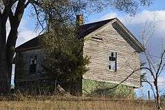
James Alexander House |
|
000000001982-09-16-0000September 16, 1982
(#82004543) |
North of Spottswood on VA 671
37°57′52″N 79°12′12″W / 37.964444°N 79.203333°W / 37.964444; -79.203333 (James Alexander House) |
Spottswood |
|
| 2 |
Archeological Site No. AU-154 |
Upload image |
000000001985-12-13-0000December 13, 1985
(#85003171) |
Address Restricted
|
Luray |
|
| 3 |
Augusta County Training School |
Upload image |
000000001986-06-19-0000June 19, 1986
(#86001400) |
VA 693
38°08′49″N 79°07′55″W / 38.146944°N 79.131944°W / 38.146944; -79.131944 (Augusta County Training School) |
Cedar Green |
|
| 4 |
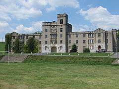
Augusta Military Academy |
|
000000001983-02-10-0000February 10, 1983
(#83003258) |
North of Staunton on U.S. 11
38°14′12″N 78°58′39″W / 38.236667°N 78.9775°W / 38.236667; -78.9775 (Augusta Military Academy) |
Fort Defiance |
|
| 5 |
Augusta Stone Church |
|
000000001973-05-09-0000May 9, 1973
(#73001994) |
U.S. 11
38°14′18″N 78°58′26″W / 38.238333°N 78.973889°W / 38.238333; -78.973889 (Augusta Stone Church) |
Fort Defiance |
|
| 6 |
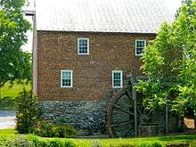
Bare House and Mill |
|
000000002002-11-21-0000November 21, 2002
(#02001364) |
157 Wilda Rd.
38°01′36″N 79°05′40″W / 38.026617°N 79.094511°W / 38.026617; -79.094511 (Bare House and Mill) |
Stuarts Draft |
|
| 7 |
Bethel Green |
|
000000001982-08-26-0000August 26, 1982
(#82004539) |
Rte. 701
38°02′31″N 79°10′34″W / 38.041944°N 79.176111°W / 38.041944; -79.176111 (Bethel Green) |
Greenville |
|
| 8 |
Blackrock Springs Site |
Upload image |
000000001985-12-13-0000December 13, 1985
(#85003169) |
Address Restricted
|
Luray |
|
| 9 |
Chapel Hill |
Upload image |
000000001978-11-16-0000November 16, 1978
(#78003006) |
East of Mint Spring on VA 654
38°04′01″N 79°04′23″W / 38.066944°N 79.073056°W / 38.066944; -79.073056 (Chapel Hill) |
Mint Spring |
|
| 10 |
Clover Mount |
|
000000001982-09-16-0000September 16, 1982
(#82004540) |
West of Greenville on VA 674
37°59′58″N 79°12′26″W / 37.999444°N 79.207222°W / 37.999444; -79.207222 (Clover Mount) |
Greenville |
|
| 11 |
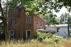
Coiner House |
|
000000001978-03-30-0000March 30, 1978
(#78003005) |
Northwest of Crimora off VA 865
38°10′02″N 78°51′48″W / 38.167222°N 78.863333°W / 38.167222; -78.863333 (Coiner House) |
Crimora |
|
| 12 |
Craigsville School |
Upload image |
000000001985-02-27-0000February 27, 1985
(#85000383) |
Railroad Ave.
38°04′46″N 79°22′48″W / 38.079444°N 79.38°W / 38.079444; -79.38 (Craigsville School) |
Craigsville |
|
| 13 |
Crimora School |
|
000000001985-02-27-0000February 27, 1985
(#85000384) |
VA 612
38°09′17″N 78°51′10″W / 38.154722°N 78.852778°W / 38.154722; -78.852778 (Crimora School) |
Crimora |
|
| 14 |
Deerfield School |
Upload image |
000000001986-06-19-0000June 19, 1986
(#86001402) |
VA 600
38°11′40″N 79°24′22″W / 38.194444°N 79.406111°W / 38.194444; -79.406111 (Deerfield School) |
Deerfield |
|
| 15 |
Estaline Schoolhouse |
Upload image |
000000001985-02-27-0000February 27, 1985
(#85000385) |
VA 601
38°03′45″N 79°21′27″W / 38.0625°N 79.3575°W / 38.0625; -79.3575 (Estaline Schoolhouse) |
Estaline Valley |
|
| 16 |
Folly |
|
000000001973-10-25-0000October 25, 1973
(#73001995) |
South of Staunton on U.S. 11
38°05′21″N 79°06′05″W / 38.089167°N 79.101389°W / 38.089167; -79.101389 (Folly) |
Staunton |
|
| 17 |
Glebe Burying Ground |
Upload image |
000000001985-10-01-0000October 1, 1985
(#85002722) |
South of Swoope on VA 876
38°06′33″N 79°13′20″W / 38.109167°N 79.222222°W / 38.109167; -79.222222 (Glebe Burying Ground) |
Swoope |
|
| 18 |
Glebe Schoolhouse |
Upload image |
000000001985-02-27-0000February 27, 1985
(#85000386) |
VA 876
38°06′36″N 79°13′17″W / 38.11°N 79.221389°W / 38.11; -79.221389 (Glebe Schoolhouse) |
Summerdean |
|
| 19 |
Hanger Mill |
Upload image |
000000001991-11-08-0000November 8, 1991
(#91001596) |
Junction of VA 801 and US 250
38°13′10″N 79°08′09″W / 38.219444°N 79.135833°W / 38.219444; -79.135833 (Hanger Mill) |
Churchville |
|
| 20 |
Harnsberger Octagonal Barn |
|
000000001982-07-08-0000July 8, 1982
(#82004541) |
VA 256 and VA 865
38°15′44″N 78°51′53″W / 38.262222°N 78.864722°W / 38.262222; -78.864722 (Harnsberger Octagonal Barn) |
Grottoes |
|
| 21 |
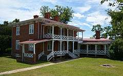
Harper House |
|
000000002006-02-01-0000February 1, 2006
(#05001623) |
3029 Stuarts Draft Hwy.
38°02′24″N 79°01′10″W / 38.04°N 79.019444°W / 38.04; -79.019444 (Harper House) |
Stuarts Draft |
|
| 22 |
Intervale |
Upload image |
000000001985-02-14-0000February 14, 1985
(#85000296) |
VA 720
38°11′51″N 79°11′21″W / 38.1975°N 79.189167°W / 38.1975; -79.189167 (Intervale) |
Swoope |
|
| 23 |
Long Glade Farm |
Upload image |
000000001996-01-22-0000January 22, 1996
(#95001560) |
VA 607, south of the junction with VA 741
38°16′58″N 79°04′14″W / 38.282778°N 79.070556°W / 38.282778; -79.070556 (Long Glade Farm) |
Mount Solon |
|
| 24 |
Maple Front Farm |
Upload image |
000000002010-08-16-0000August 16, 2010
(#10000562) |
439 Cale Spring Rd.
38°03′33″N 79°14′26″W / 38.059167°N 79.240556°W / 38.059167; -79.240556 (Maple Front Farm) |
Middlebrook |
|
| 25 |
Middlebrook High School |
Upload image |
000000001985-02-27-0000February 27, 1985
(#85000387) |
VA 670
38°03′00″N 79°12′48″W / 38.05°N 79.213333°W / 38.05; -79.213333 (Middlebrook High School) |
Middlebrook |
|
| 26 |
Middlebrook Historic District |
Upload image |
000000001983-02-10-0000February 10, 1983
(#83003259) |
Junction of VA 252 and 876
38°03′07″N 79°12′53″W / 38.051944°N 79.214722°W / 38.051944; -79.214722 (Middlebrook Historic District) |
Middlebrook |
|
| 27 |
Middlebrook School |
Upload image |
000000001985-02-27-0000February 27, 1985
(#85000388) |
VA 670
38°03′00″N 79°12′48″W / 38.05°N 79.213333°W / 38.05; -79.213333 (Middlebrook School) |
Middlebrook |
|
| 28 |
A. J. Miller House |
Upload image |
000000001982-07-08-0000July 8, 1982
(#82004542) |
VA 639
38°01′25″N 79°13′57″W / 38.023611°N 79.2325°W / 38.023611; -79.2325 (A. J. Miller House) |
Middlebrook |
|
| 29 |
Hannah Miller House |
Upload image |
000000001979-05-24-0000May 24, 1979
(#79003028) |
North of Mossy Creek off VA 747
38°21′33″N 79°01′48″W / 38.359167°N 79.03°W / 38.359167; -79.03 (Hannah Miller House) |
Mossy Creek |
|
| 30 |
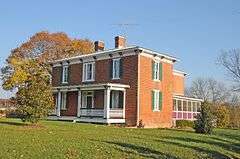
Henry Miller House |
Upload image |
000000001979-05-23-0000May 23, 1979
(#79003029) |
East of Mossy Creek on VA 42
38°21′26″N 79°01′41″W / 38.357222°N 79.028056°W / 38.357222; -79.028056 (Henry Miller House) |
Mossy Creek |
|
| 31 |
Henry Mish Barn |
Upload image |
000000001983-02-10-0000February 10, 1983
(#83003260) |
North of Middlebrook on VA 876
38°03′53″N 79°13′25″W / 38.064722°N 79.223611°W / 38.064722; -79.223611 (Henry Mish Barn) |
Middlebrook |
|
| 32 |
Moffett's Creek Schoolhouse |
Upload image |
000000001985-02-27-0000February 27, 1985
(#85000389) |
VA 681
38°00′08″N 79°18′28″W / 38.002222°N 79.307778°W / 38.002222; -79.307778 (Moffett's Creek Schoolhouse) |
Newport |
|
| 33 |
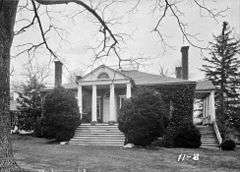
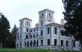
Mt. Airy |
Upload image |
000000002012-08-22-0000August 22, 2012
(#12000538) |
Access road off of Technology Dr., southeast of Augusta County Government Center
38°11′29″N 79°00′26″W / 38.191345°N 79.007217°W / 38.191345; -79.007217 (Mt. Airy) |
Verona |
home of American folk artist Grandma Moses
|
| 34 |
Mount Pleasant |
Upload image |
000000001989-10-30-0000October 30, 1989
(#89001792) |
879 Middle River Rd.
38°14′39″N 79°05′24″W / 38.244167°N 79.09°W / 38.244167; -79.09 (Mount Pleasant) |
Staunton |
|
| 35 |
Mt. Meridian Schoolhouse |
|
000000001985-02-27-0000February 27, 1985
(#85000390) |
VA 865
38°15′35″N 78°51′38″W / 38.259722°N 78.860694°W / 38.259722; -78.860694 (Mt. Meridian Schoolhouse) |
Mt. Meridian |
|
| 36 |
Mt. Sidney Historic District |
Upload image |
000000001998-10-30-0000October 30, 1998
(#98001313) |
Lee Highway, Mt. Sidney School Ln., and Pottery Shop Ln.
38°15′22″N 78°57′36″W / 38.256111°N 78.96°W / 38.256111; -78.96 (Mt. Sidney Historic District) |
Mt. Sidney |
|
| 37 |
Mt. Sidney School |
Upload image |
000000001985-02-27-0000February 27, 1985
(#85000391) |
U.S. Route 11
38°15′22″N 78°57′43″W / 38.256111°N 78.961944°W / 38.256111; -78.961944 (Mt. Sidney School) |
Mt. Sidney |
|
| 38 |
Mt. Torry Furnace |
|
000000001974-02-25-0000February 25, 1974
(#74002231) |
Southwest of Waynesboro on VA 664 in the George Washington National Forest
37°56′43″N 78°57′53″W / 37.945278°N 78.964722°W / 37.945278; -78.964722 (Mt. Torry Furnace) |
Sherando |
|
| 39 |
Mt. Zion Schoolhouse |
Upload image |
000000001985-02-27-0000February 27, 1985
(#85000392) |
VA 747
38°20′12″N 79°07′37″W / 38.336667°N 79.126944°W / 38.336667; -79.126944 (Mt. Zion Schoolhouse) |
Mount Solon |
|
| 40 |
New Hope High School |
Upload image |
000000001985-02-27-0000February 27, 1985
(#85000393) |
VA 608
38°12′04″N 78°54′14″W / 38.201111°N 78.903889°W / 38.201111; -78.903889 (New Hope High School) |
New Hope |
|
| 41 |
North River High School |
Upload image |
000000001985-02-27-0000February 27, 1985
(#85000394) |
VA 42
38°18′54″N 79°04′46″W / 38.315°N 79.079444°W / 38.315; -79.079444 (North River High School) |
Moscow |
|
| 42 |
Old Providence Stone Church |
|
000000001972-12-05-0000December 5, 1972
(#72001383) |
Junction of VA 613 and VA 620
37°57′40″N 79°13′36″W / 37.961111°N 79.226667°W / 37.961111; -79.226667 (Old Providence Stone Church) |
Spottswood |
|
| 43 |
Paine Run Rockshelter |
Upload image |
000000001985-12-13-0000December 13, 1985
(#85003170) |
Address Restricted
|
Luray |
|
| 44 |
Lewis Shuey House |
Upload image |
000000001983-02-10-0000February 10, 1983
(#83003261) |
South of Swoope on VA 713
38°07′05″N 79°13′38″W / 38.118056°N 79.227222°W / 38.118056; -79.227222 (Lewis Shuey House) |
Swoope |
|
| 45 |
Skyline Drive Historic District |
|
000000001997-04-28-0000April 28, 1997
(#97000375) |
Shenandoah National Park, from the N entrance station at Front Royal to the S entrance station at Rockfish Gap
38°32′54″N 78°27′38″W / 38.548333°N 78.460556°W / 38.548333; -78.460556 (Skyline Drive Historic District) |
Luray |
part of the Historic Park Landscapes in National and State Parks Multiple Property Submission (MPS)
|
| 46 |
Sugar Loaf Farm |
|
000000001991-07-09-0000July 9, 1991
(#91000884) |
West of junction of VA 695 and VA 710
38°06′10″N 79°10′40″W / 38.102778°N 79.177778°W / 38.102778; -79.177778 (Sugar Loaf Farm) |
Staunton |
|
| 47 |
Swannanoa |
|
000000001969-10-01-0000October 1, 1969
(#69000221) |
South of junction of VA 610 and U.S. 250
38°01′41″N 78°52′08″W / 38.028056°N 78.868889°W / 38.028056; -78.868889 (Swannanoa) |
Waynesboro |
|
| 48 |
Tinkling Spring Presbyterian Church |
|
000000001973-04-11-0000April 11, 1973
(#73001993) |
VA 608, 1 mile (1.6 km) south of the junction with VA 636 and VA 631
38°05′06″N 78°58′59″W / 38.085°N 78.983056°W / 38.085; -78.983056 (Tinkling Spring Presbyterian Church) |
Fishersville |
|
| 49 |
Valley Railroad Stone Bridge |
|
000000001974-11-19-0000November 19, 1974
(#74002105) |
South of Jolivue off VA 654
38°05′21″N 79°04′40″W / 38.089167°N 79.077778°W / 38.089167; -79.077778 (Valley Railroad Stone Bridge) |
Jolivue |
|
| 50 |
Verona School |
Upload image |
000000001985-02-27-0000February 27, 1985
(#85000395) |
U.S. Route 11
38°12′13″N 79°00′27″W / 38.203611°N 79.0075°W / 38.203611; -79.0075 (Verona School) |
Verona |
|
| 51 |
Walker's Creek Schoolhouse |
Upload image |
000000001985-02-27-0000February 27, 1985
(#85000396) |
VA 602
38°00′57″N 79°19′54″W / 38.015833°N 79.331667°W / 38.015833; -79.331667 (Walker's Creek Schoolhouse) |
Newport |
|
| 52 |
West View Schoolhouse |
Upload image |
000000001985-02-27-0000February 27, 1985
(#85000397) |
VA 774 and 773
38°16′02″N 78°54′42″W / 38.267222°N 78.911667°W / 38.267222; -78.911667 (West View Schoolhouse) |
Weyers Cave |
|
| 53 |
Weyers Cave School |
Upload image |
000000001985-02-27-0000February 27, 1985
(#85000398) |
VA 276
38°17′17″N 78°54′33″W / 38.288056°N 78.909167°W / 38.288056; -78.909167 (Weyers Cave School) |
Weyers Cave |
part of the Public Schools in Augusta County Virginia 1870-1940 TR |


.jpg)

