National Register of Historic Places listings in Winchester, Virginia
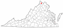
Location of Winchester in Virginia
This is a list of the National Register of Historic Places listings in Winchester, Virginia.
This is intended to be a complete list of the properties and districts on the National Register of Historic Places in the independent city of Winchester, Virginia, United States. The locations of National Register properties and districts for which the latitude and longitude coordinates are included below, may be seen in a Google map.[1]
There are 21 properties and districts listed on the National Register in the city, including 1 National Historic Landmark.
- This National Park Service list is complete through NPS recent listings posted December 2, 2016.[2]
Current listings
| [3] | Name on the Register[4] | Image | Date listed[5] | Location | Description |
|---|---|---|---|---|---|
| 1 | Abram's Delight | 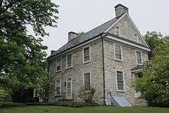 |
(#73002230) |
Parkview St. and Rouss Spring Rd. 39°10′09″N 78°09′39″W / 39.169167°N 78.160833°W |
Oldest house in Winchester, built by Simon Taylor in 1754, for Isaac Hollingsworth, the son of Abraham Hollingsworth, who arrived in 1728.[6] |
| 2 | Patsy Cline House | 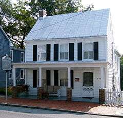 |
(#05001230) |
608 S. Kent St. 39°10′47″N 78°09′51″W / 39.179722°N 78.164167°W |
|
| 3 | Douglas School | 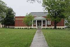 |
(#00000558) |
598 N. Kent St. 39°11′39″N 78°09′25″W / 39.194167°N 78.156944°W |
Built in 1927 as a "separate but equal" school for African American students but converted to a community center in 1966 after desegregation; may have been named for Frederick Douglass, despite the spelling difference.[7] |
| 4 | Fair Mount | 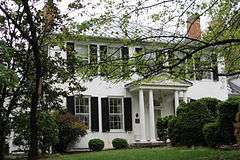 |
(#03001431) |
311 Fairmont Ave. 39°11′19″N 78°10′06″W / 39.188611°N 78.168333°W |
Built in 1809 by Lewis Barnett for local merchant Joseph Tidball; remodeled in 1929 in Colonial Revival Style.[8] |
| 5 | Fort Loudoun Site | 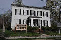 |
(#13000650) |
419 North Loudoun St.[9] 39°11′21″N 78°09′50″W / 39.189167°N 78.163927°W |
Archaeological site of fort erected under George Washington's supervision. |
| 6 | Frederick County Courthouse |  |
(#01000690) |
20 N. Loudoun St. 39°11′02″N 78°09′52″W / 39.183889°N 78.164444°W |
|
| 7 | Glen Burnie | 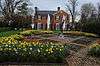 |
(#79003305) |
801 Amherst St. 39°11′13″N 78°10′43″W / 39.186944°N 78.178611°W |
Built in 1794 by Robert Wood, son of James and Mary Wood, who founded Frederick Town (later Winchester) in 1744.[10] |
| 8 | Handley Library |  |
(#69000364) |
Northwest corner of Braddock and Piccadilly Sts. 39°11′14″N 78°09′59″W / 39.18712°N 78.16647°W |
Funded by Scranton, Pennsylvania, coal baron, Judge John Handley, and built by New York architects J. Stewart Barney and Henry Otis Chapman, it is "perhaps Virginia's purest expression of the regal and florid Beaux Arts classicism."[11] It opened in August 1913.[12] |
| 9 | John Handley High School |  |
(#98001070) |
425 Handley Boulevard 39°10′38″N 78°10′29″W / 39.177222°N 78.174722°W |
|
| 10 | Hawthorne and Old Town Spring | 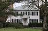 |
(#13000364) |
610 and 730 Amherst St. 39°11′18″N 78°10′34″W / 39.188253°N 78.176016°W |
Late Georgian- to Federal-style stone house built in 1811, a spring house built in 1816, and a spring. |
| 11 | Hexagon House | 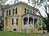 |
(#87001550) |
530 Amherst St. 39°11′16″N 78°10′30″W / 39.18771°N 78.17504°W |
Completed in 1874 by architect Brice Leatherman for James W. Burgess in a style designed to open up interior space and let in more natural light. Even rarer than octagon houses built on similar principles.[13] |
| 12 | Thomas J. Jackson Headquarters | 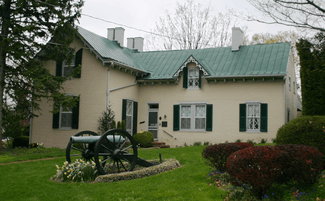 |
(#67000027) |
415 N. Braddock St. 39°11′23″N 78°09′58″W / 39.189722°N 78.166111°W |
|
| 13 | Adam Kurtz House |  |
(#76002233) |
Northeast corner of Braddock and Cork Sts. 39°10′56″N 78°10′05″W / 39.182222°N 78.168056°W |
The house served as George Washington's headquarters while he was supervising the construction of Fort Loudoun in 1755-56.[14] |
| 14 | Daniel Morgan House | 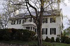 |
(#12001274) |
226 Amherst St. 39°11′11″N 78°10′09″W / 39.186315°N 78.169186°W |
|
| 15 | Mount Hebron Cemetery and Gatehouse |  |
(#09000163) |
305 E. Boscawen St. 39°10′57″N 78°09′35″W / 39.1825°N 78.159722°W |
Established in 1844 on two older churchyards. Expanded in 1866 to include Stonewall Cemetery for 2,576 Confederate war dead. Iron fence added in 1891 and limestone gatehouse for superintendent added in 1902.[15] |
| 16 | Old Stone Church | 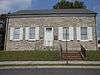 |
(#77001538) |
304 E. Piccadilly St. 39°11′06″N 78°09′38″W / 39.185°N 78.160556°W |
|
| 17 | Triangle Diner | 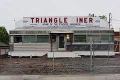 |
(#10000148) |
27 W. Gerrard St. 39°10′36″N 78°10′07″W / 39.176717°N 78.168689°W |
|
| 18 | The George Washington Hotel | 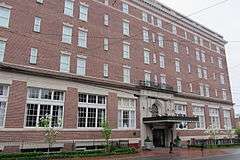 |
(#10000383) |
103 E Piccadilly St. 39°11′08″N 78°09′47″W / 39.185556°N 78.163056°W |
|
| 19 | Winchester Coca-Cola Bottling Works |  |
(#08000895) |
1720 Valley Ave. 39°10′14″N 78°10′38″W / 39.170561°N 78.177317°W |
|
| 20 | Winchester Historic District | |
(#80004318) |
U.S. Routes 11, 17/50, and 522; also 120 and 126 N. Kent St.; also the 300-400 blocks of N. Cameron St., 12 Clark St., 110 E. Fairfax La. and 145 N. Baker St.; also Amherst, Boscawen, Gerrard, Pall Mall, and Stewart Sts. 39°11′02″N 78°10′00″W / 39.183889°N 78.166667°W |
Second, third, and fourth sets of boundaries represent boundary increases of February 20, 2003, September 12, 2008, and January 5, 2016 |
| 21 | Winchester National Cemetery |  |
(#96000032) |
401 National Ave. 39°11′03″N 78°09′25″W / 39.184167°N 78.156944°W |
See also
| Wikimedia Commons has media related to National Register of Historic Places in Winchester, Virginia. |
- List of National Historic Landmarks in Virginia
- National Register of Historic Places listings in Virginia
- National Register of Historic Places listings in Frederick County, Virginia
References
- ↑ The latitude and longitude information provided in this table was derived originally from the National Register Information System, which has been found to be fairly accurate for about 99% of listings. For about 1% of NRIS original coordinates, experience has shown that one or both coordinates are typos or otherwise extremely far off; some corrections may have been made. A more subtle problem causes many locations to be off by up to 150 yards, depending on location in the country: most NRIS coordinates were derived from tracing out latitude and longitudes off of USGS topographical quadrant maps created under the North American Datum of 1927, which differs from the current, highly accurate WGS84 GPS system used by most on-line maps. Chicago is about right, but NRIS longitudes in Washington are higher by about 4.5 seconds, and are lower by about 2.0 seconds in Maine. Latitudes differ by about 1.0 second in Florida. Some locations in this table may have been corrected to current GPS standards.
- ↑ "National Register of Historic Places: Weekly List Actions". National Park Service, United States Department of the Interior. Retrieved on December 2, 2016.
- ↑ Numbers represent an ordering by significant words. Various colorings, defined here, differentiate National Historic Landmarks and historic districts from other NRHP buildings, structures, sites or objects.
- ↑ National Park Service (2008-04-24). "National Register Information System". National Register of Historic Places. National Park Service.
- ↑ The eight-digit number below each date is the number assigned to each location in the National Register Information System database, which can be viewed by clicking the number.
- ↑ "Winchester-Frederick County Historical Society". Abram's Delight. Winchester-Frederick County Historical Society. Retrieved 20 May 2012.
- ↑ Sieff, Kevin (12 December 2010). "Alumni, NAACP in Winchester, Va., fighting over spelling of Douglas School's name". Washington Post. Retrieved 20 May 2012.
- ↑ "Fair Mount - Winchester, Virginia". waymarking.com. Retrieved 20 May 2012.
- ↑ "Fort Loudoun History". French and Indian War Foundation. Retrieved 2014-07-07.
- ↑ "Glen Burnie Historic House and Gardens". Museum of the Shenandoah Valley. Retrieved 20 May 2012.
- ↑ "Virginia Main Street Communities: Handley Library". National Park Service. Retrieved 20 May 2012.
- ↑ "Handley Regional Library: The First One Hundred Years". Handley Regional Library. Retrieved 20 May 2012.
- ↑ "The Hexagon House: 530 Amherst Street". Preservation of Historic Winchester, Inc. Retrieved 20 May 2012.
- ↑ "Winchester-Frederick County Historical Society". George Washington's Office. Winchester-Frederick County Historical Society. Retrieved 20 May 2012.
- ↑ "Mount Hebron Cemetery: History". Mount Hebron Cemetery. Retrieved 20 May 2012.


This article is issued from Wikipedia - version of the 11/10/2016. The text is available under the Creative Commons Attribution/Share Alike but additional terms may apply for the media files.